John O’Connor – Remote Sensing and Ancient Polynesian Landscapes
Currently working with revision @ 2012-07-07 18:27:26 by admin. Current version
Remote Sensing and Ancient Polynesian Landscapes
John Thornton O’Connor
University of Hawaii-Manoa
Thesis
Remote sensing data collection enables the visual identification of cultural features and the generation of spatial structure information about aggregate artifacts.
Hawaiian archaeological features are constructed from individual basalt rocks. Artifact structures are aggregates of discrete objects organized into spatially coherent sets. What remote sensing methods are most effective for the identification of aggregate archaeological features across prehistoric Hawaiian landscapes?
Solution and Data Requirements
The goal is to identify features at the scale of the object set. Solutions must be automated, low cost, and capable of large area coverage with good spatial precision. Data acquisition sensor must capture imagery of large structures, reveal obscured features, and produce images of sufficient precision for structural attribute analysis.
Remote Sensing Platforms
Ground-secured: Pole Aerial Photography (PAP), Kite Aerial Photography (KAP)
Unmanned Aerial Vehicles and Systems (UAV/UAS): suborbital remote-controlled fixed-wing aircraft, Gatewing X100 low altitude surveillance craft, NASA Pathfinder atmospheric satellite
Light Detection and Ranging (LIDAR) aircraft-supported imaging
Orbital satellite imaging: Quickbird (4-band) and WorldView-2 (8-band) earth observation satellites
Methods
True-color, near-infrared, LIDAR, and multispectral imagery were acquired from remote sensing platforms. Multi-image orthophotos and point clouds created in Agisoft Photoscan and Microsoft Photosynth. True-color and near-infrared orthophotos were then georeferenced in ERDAS IMAGINE and ESRI ArcGIS. Digital elevation models (DEM) were created with ESRI ArcGIS from LIDAR data and point clouds of specific archaeological structures. Orthophotos and LIDAR-derived DEMs were layered on top of satellite-acquired multispectral imagery for spatially defined artifact analysis.
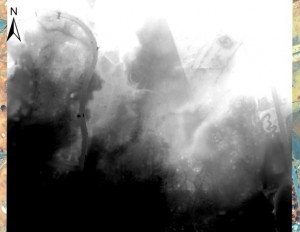
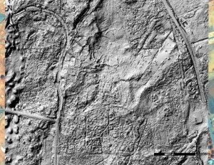
Light Detection and Ranging (LIDAR)
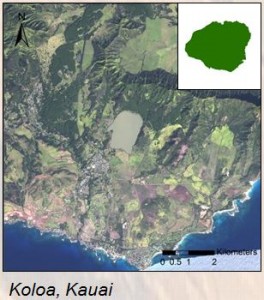
LIDAR is a remote sensing approach whereby light pulsing is used to generate high resolution spatial data. LIDAR-derived imagery depicts prehistoric field systems at Koloa ahupuaa, Kona district, Kauai.
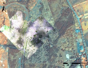
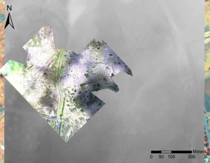
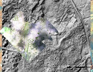
Image manipulation refines observation of Hawaiian cultural features and agricultural fields. The following images were created as 1) true-color orthophoto with WorldView-2 8-band image, 2) true-color orthophoto with LIDAR-derived imagery, 3) LIDAR-derived image modified for improved feature resolution, 4) LIDAR-derived hillshade at 1.0 exaggeration, 5) LIDAR-derived hillshade at 10.0 exaggeration, and 6) true-color orthophoto with LIDAR-derived hillshade.
Multispectral Imaging
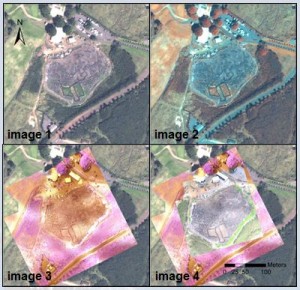
Diverse photographic approaches and spectral bandwidth combinations reveal distinct spatial information about basalt archaeological structures. The following figure shows images captured by the WorldView-2 satellite with 1) true-color, 2) altered color for improved basalt visualization, 3) a high resolution near-IR overlay obtained by remote control UAV, and 4) a high resolution true-color layer acquired with KAP. Images display Preserve 1, Koloa ahupuaa, Kona district, Kauai.
Conclusions
LIDAR-derived digital elevation models are most effective for the identification of aggregate archaeological structures and anthropogenic terrain modification. Partially obscured cultural features become apparent through DEM manipulation revealing habitation platforms, agricultural field boundaries, and religious structures. Orthophotos created from KAP and low altitude UAV-acquired photographs complement satellite imagery with improved resolution of identified ancient landscapes.
Acknowledgements
Special thanks: Dr. Carl Lipo, Dr. Suzanne Wechsler, and Dr. Christopher Lee of California State University-Long Beach; Dr. Terry Hunt of the University of Hawaii-Manoa; Dr. David Burney and Lida Pigott Burney of the National Tropical Botanical Garden; Paul Nesbit, Briton Voorhees, Mike Ferris, Jacob Kovalchik, Matt Lucas, Ted Ralston, Chuck Devaney, Dave Hummer, Lawrence Fujiwara, Samantha Hauser, and Avery Sandborn.
Research funding has been provided by the National Science Foundation, REU-Geospatial Research and Mapping (GRAM) Grant No. 1005258.
Mahalo nui au i kuu ohana no ko lakou kokua mau loa. Aloha au ia oukou.