|
Lecture Notes for the Midterm
-
Introduction
-
Nature of Geography
-
Human-environment tradition focussing on topics showing the human impact on
the natural environment or the natural environment's impact on human society
-
Regional geography tradition dedicated to the synthesis of natural and social
information about a region and differentiating one region from another
-
Spatial tradition focussing on the production and testing of specialized
knowledge about the distribution of particular phenomena and the processes
behind their distributions
-
Physical geography tradition holds to the analysis of physical and biological
processes on Planet Earth and was a little dismayed when some geographers
started venturing into social science questions over a century ago
-
Geography and Mars
-
How the four traditions apply to the study of Mars: the latter three clearly
fit, while the human-environment tradition awaits sustained human presence on
Mars (though there are several human geographers taking up martian topics!)
-
The contribution of geography's regional tradition to exploration of a
different planet: "Areography": the orders of relief scheme I'll use to
organize martian landscapes
-
The hundred or so geographers I've identified doing research on Mars are
dominated by geomorphologists (æolian, fluvial, and glacial
geomorphologists) with a substantial minority of GIScientists (GIS, remote
sensing, and spatial statisticians), though I have also found a few human
geographers doing work on the history of Mars research and on space policy:
I've written an article about their activities, which I hope The
Professional Geographer will publish after review.
- END 01/21/15
-
History of Mars exploration
-
History of Mars observation from Earth
- The "eyeball method":
- Early astronomer/astrologers from Mesopotamia (Iraq), India, China,
Egypt, and Greece noted and described the regularities in star motions across
the sky: They also noticed that five "stars" were not well-behaved, that they
moved faster or slower than the "others," and even went backwards or
retrograde. These five wanderers ("astra planeta") were Mercury, Venus, Mars,
Jupiter, and Saturn.
- The ancient Indians mentioned a retrogation of Mars in 3,010 BCE, in the
Mahabharata (the saga was put together from ~1,750 BCE to ~400 CE)
- The Chaldean astronomer/astrologers of ancient Mesopotamia compiled a
database of astronomical observations that they tried to correlate with
different social, economic, and environmental events -- Mars is often
mentioned in these tablets, the Enuma Anu Enlil, which date back to 652
BCE and continued until 60 BCE. Here is a sample: "That month, the equivalent
for 1 shekel of silver was: barley [lacuna] kur; mustard, 3 kur ... At that
time, Jupiter was in Scorpio; Venus was in Leo, at the end of the month in
Virgo; Saturn was in Pisces; Mercury and Mars, which had set, were not
visible."
- Chinese dynastic historians noted conjunctions of planets including Mars
back to the fourth century BCE
- The Mayans from 1800 BCE to the time of Columbus developed elaborate and
accurate calendars, especially during their Classic phase from 250 - 900 CE.
The Spanish destroyed most of their written records, but four priestly
handbooks, or codices, survive. The Dresden Codex includes a "Mars Beast
Table" that predicts Mars' motions and retrogations.
- The ancient Greeks were really bugged by Mars' and other planets'
occasional retrograde episodes and came up with various schemes.
- Aristotle (lived ~384-322 BCE) observed an occulation of Mars by the Moon
around 356 or 357 BCE: the Moon passing in front of Mars. He figured out that
Mars had to be farther out than the Moon.
- Aristarchus (~310-230 BCE) had come up with the idea that the sun was the
center of the solar system and the planets revolved around it: He didn't get
too far with this seemingly nutty notion.
- Hipparchus (~190-120 BCE) described the five planets' orbits as
"deferents" around the earth
- Ptolemy (~90-168 CE) added little circular sub-orbits, or "epicycles"
along the deferents to account for the retrograde episodes.
- The collapse of Graeco-Roman civilization put an end to work on Mars or
any other science for a long time.
- The rise of Islam rejuvenated Arab culture and supported mathematical and
scientific work, including mastery of the Greek classics and developments on
them. Algebra and the Arabic numeral system were developed, and Ptolemy's
system was edited by Ibn al-Haytham around the 10th century and Nasir ad-Din
at-Tusi in the late 13th century to make it better able to predict planetary
motion. These achievements were brought to Europe at least partly because of
the Crusades.
- Europeans in the throes of the Renaissance and their re-introduction to
Classical era and Arab science, got into the swing of things, too:
- Mikołaj Kopernik or Nicholas Copernicus argued in 1543 that the
planets' motion made more sense if Earth was itself a planet and rotated about
a north-south axis while revolving with the other planets around the Sun. His
observations squared better with Aristarchus He assumed that all six planets'
orbits were perfect circles, which meant that there were still little
discrepancies. He was forced to account for those by keeping Ptolemy's
epicycles. This was an absolutely revolutionary idea to Christendom: That
Earth wasn't the center of creation.
- Tyge Brahe, Latinized as Tycho Brahe, was a dedicated and obsessive
observational astronomer in Denmark, Sweden, Germany, and Bohemia, who lived
from 1546 to 1601. Brahe wasn't much into theory, but he was a really
original engineer who built new observational instruments for measuring the
positions of objects in the sky. He instituted a program of nightly
observation and trained others in the art. He had kept meticulous records of
the precise locations of various stars and the planets in a huge database. He
often focussed on Mars because of its seeming anomalies of motion, but he
never theorized from his observations. He was aware of Copernicus' work, but
found it implausible because it required the abandonment of Aristotelian
physics.
- Johannes Kepler came to work with him toward the very end of his life, in
1600, and studied 20 years of his records, trying to make sense of them. He
found himself in agreement with Copernicus, which annoyed Brahe no end. So
Brahe decided not to share all his data with Kepler but set him working only
on the data concerning Mars, his toughest problem. Kepler found that the best
way to make sense of Mars' orbit was to apply Copernicus' heliocentric theory
but relax the assumption about a perfectly circular orbit. In 1609, years
after Brahe had died (some even speculate that he offed Brahe to get hold of
his data), Kepler posited an elliptical orbit for Mars and three laws of
motion and got rid of the epicycles.
- The orbits of the planets are ellipses, with the Sun at one of the two
foci of the ellipse.
- The line connecting the planet to the Sun sweeps out equal areas in equal
times, so it slows down at aphelion and speeds up at perihelion
- If you compare two planets' orbits, the ratio of the squares of their
revolutionary periods is the same as the cubes of their semimajor axes: The
period a planet requires to go around the Sun increases rapidly with the
radius of its orbit. The farther out they are, the drastically longer their
years are.
- Telescope-aided observation
- In 1609, the same year Kepler published his Laws of Motion, Galileo built
and operated the first astronomical telescope. He trained it on Mars and
began recording his observations. He was looking for evidence of Mars showing
phases like the Moon, which Copernicus and Kepler reasoned the planets would
show. His telescope was too primitive and Galileo honestly reported that he
couldn't see the changing phases but he did say Mars did not look perfectly
round to him. For his defense of Copernicus' heliocentric theory against
specific orders of the Church, Galileo got into trouble with the Inquisition
and was ordered into prison, a sentence later commuted to lifelong house
arrest.
- In 1636, another Italian astronomer, Francisco Fontana, used a telescope
to observe Mars and made the first drawing of the planet. His drawing showed
Mars in gibbous phase, showing that the planet shows lunar-like phases, as
Copernicus and Kepler expected. He also said its surface wasn't of an even
shade. His drawings show a dark spot in the middle, now thought to be a
defect in his telescope.
- In 1659, Dutch astronomer Christiaan Huygens was able to get such a good
bead on Mars that he could establish that Mars rotates around a north-south
axis and its daylength is slightly longer than Earth's. He drew maps of what
he was seeing and recorded a dark triangular patch near Mars' equator, which
we now call Syrtis Major.
- In the 1660s, Jean Dominique Cassini observed the polar caps of Mars as
bright spots. He also refined Huygens' estimate of Mars' day length to about
24 hours and 40 minutes. In 1672, he figured out the distance between Mars
and the earth by coördinating with a friend in French Guiana in South
America to take measurements at the same time. He could use this parallax to
figure out how far Mars was. From Kepler's Third Law, Cassini knew that Mars'
orbital period was roughly 1.5 times that of Earth, so, if he could figure out
how far apart Earth and Mars were at opposition, he knew that the Earth-Sun
distance would be approximately twice the Earth-Mars distance. Using this,
Cassini figured the Astronomical Unit (or Earth-Sun distance) at 140 million
km is awfully close to the actual distance known today of roughly 150 million
km.
- In 1719, Cassini's nephew, Giacomo Maraldi, noticed that his uncle's
white spots grew and shrank, and that the dark areas on Mars changed in shape.
From this, he figured Mars had seasons.
- In 1786, William Herschel also observed these changes. He was able to
surmise the angular tilt of Mars as roughly 25°, which, again, confirmed
that Mars had to have seasons. He thought the dark areas might be seas and
some of the light areas that moved around might be clouds and vapors. He also
figured that the bright polar spots were thin sheets of snow and ice. He
noticed that faint stars that passed near Mars were not dimmed, and he
inferred that meant Mars had a very thin atmosphere.
- In 1809, Honoré Flaugergues spots variations he calls "yellow
clouds" on the surface of Mars. These were probably dust storms.
- The Geographic Period: Telescopy plus mapping
- As telescopes improved, sketches of Mars did, too. In 1800, Johann
Hieronymus Schroeter makes drawings of Mars.
- People really began to look forward to martian oppositions (when Mars is
on the opposite side of Earth from the Sun, thus lined up at their closest).
Some oppositions are closer than others, depending on where in the two
planets' orbits the opposition occurs. The 1830 one was a good one, and folks
were out there with their telescopes.
- William Beer and Johann H. von Mädler assembled the first real map
of Mars in 1840. They came up with the latitude and longitude grid used
pretty much today. They also refined Cassini's refinement of Huygens' estimate
of the martian day: 24 hours 37 minutes 22.6 seconds.
- William Whewell started speculating about life on Mars in 1854, saying
that the dark areas might be greenish seas contrasting with red land.
- Jesuit monk Angelo Secchi draws a map in 1863 and refers to "canali" or
channels for the dark areas. He also calls the dark triangle of Syrtis Major
the "Atlantic Canal."
- In 1860, the dark areas are suggested to be vegetation, changing with the
seasons, by Emmanuel Liais.
- In 1867, Richard Anthony Proctor creates a map of Mars and his
pinpointing of the prime meridian is the one used today.
- Pierre Jules Janssen and Sir William Huggins pioneer the application of
spectroscopy to Mars in 1867. They try to detect oxygen and water vapor. They
are not successful.
- In 1873, Camille Flammarion agrees with Liais that there might be
vegetation there and wonders if it's vegetation that creates the reddish color
of Mars.
- The 1877 opposition was a doozy, which coïncides with the advent of
powerful telescopes.
- Asaph Hall was out there looking for moons, figuring Earth has one,
Jupiter has four, so Mars should have two. He was about to give up but his
wife kept after him and on the 11th and 16th of August, he spotted first one
and then the other: Phobos and Deimos.
- Giovanni Schiaparelli, head of the Brera Observatory in Milan, mapped the
dark and light features of Mars, some 65 of them, and gave them names, most of
which we still use today. His map showed a bunch of intersecting lines, which
he called "canali," just like Father Secchi did. Brownie points to anyone who
finds the big, big error in the Boyce textbook concerning Schiparelli's map.
Schiparelli's canali become a huge growth industry, the Face on Mars of his
time, taking on a life of their own in others' hands.
- William Pickering of Harvard was seeing these channels, too, but in 1892,
he saw one running across "Mare Eruthraeum," a dark area that Schiaparelli
thought might be an ocean. Realizing that a "canal" can't cut across an
"ocean," he realized something was amiss and that the dark areas were probably
not water bodies after all. Maybe vegetation he thought.
- In 1892, Edward Emerson Barnard spotted craters on Mars. No-one else
paid much attention, but it's an interesting early counterpoint to the canals
craze. He also said he tried and tried to see all these canals and couldn't
for the life of him.
- In 1893, someone gives one Percival Lowell a book about Mars for
Christmas (Camille Flammarion's la planèe Mars). It bowls him
over and he begins to obsess on it. Most of us
obsess on whatever craze gets our attention, but Percival Lowell was the son
of a rich Boston family with enormous resources to throw at his interests. He
decides to build an observatory in Arizona (to reduce atmospheric twinkling
due to moisture). He became a professional astronomer and in 1902 is
appointed to MIT as non-resident astronomer.
- In 1895, 1906, and 1908, he published a series of books called Mars,
Mars and Its Canals, and Mars, the Abode of Life, in which he laid
out his elaborate theories built on wild extrapolation from the data. These
linearities so many people were seeing on Mars were, in fact, canals. Such
extensive canalization he saw as signs of intelligent life, life desperate to
cope with a drying planet and engaging in planet-scale engineering to survive.
The book became a best-seller and really began to affect Western culture.
- Scientists, however, were, as usual, skeptical creatures, and a few began
to question this canals business.
- Alfred Russell Wallace, who came up with the theory of evolution a little
later than Darwin but almost beat him to the punch in publishing it, went
after Lowell. He wrote a book describing his own experiments in measuring the
light spectra from Mars and concluded that the place was really, really cold,
about -35° F, so Lowell's claim of water canals had to be "all wet." He
figured that the polar ice caps had to be mostly frozen carbon dioxide, not
water ice. He said, near as he could tell, Mars was completely hostile to
life.
- In 1912, Svante Arrhenius argued that Mars might be covered with salts.
In winter, the water on Mars freezes and the salts take on a light, playa
color. When the warmer temperatures of summer melt the polar caps in summer,
the salts wet and darken. No life necessary.
- Other scientists reported having trouble seeing canals, let alone
anything more elaborate based on canals.
- Lowell responded to scientific criticism by turning to the public for
support, giving public lectures and writing articles for popular magazines.
In other words, he began to shun the peer review process that is the
foundation of science.
- When he did this, many other scientists began to shy away from Mars,
figuring it had become the bailiwick of crackpots.
- A few, however, got caught up in it all.
-
Nikola Tesla, inventor of
Alternating Current among other things, claimed to detect radio signals from
Mars in 1899 and worked on a "Teslascope" to communicate with Mars
- Guglielmo Marconi, of radio fame, also claimed to have heard from an
alien radio transmitter a few years after Tesla's reports. Critics thought he
was just picking up another radio station's interference.
- By the time of Lowell's death, most astronomers thought that the planet
was not only uninhabited by canal-building intelligent aliens but
uninhabitable.
- Really powerful telescopes began to be aimed at Mars in the early
twentieth century: The Hale 60" telescope at Mt. Wilson in 1909 turned up
nary a single narrow, straight canal or any other geometric pattern.
- In 1913, astronomer Edward Maunder did a psychological experiment showing
how the human eye tends to see patterns linking random lines and circles and
the farther the observer was from the random pattern, the more likely they
were to report linearities linking things in the pattern.
- A few hardy souls held out for canals right up until the Mariner flybys
put the matter solidly to rest.
- New toys, new Mars: Spectral analysis
- Basic idea of spectroscopy
- Radiant energy is refracted into a spectrum, as when a prism or a
diffraction grating is placed in front of a light beam
- Electromagnetic energy can be displayed by wavelengths, and a spectrum
can be represented as intensity readings by wavelength
- A spectrum can be continuous across wavelengths or show variations where
the spectrum is less or more intense at one wavelength than at an adjacent
wavelength
- Spectroscopy is the study of radiation as it is emitted by radiant
objects and then absorbed, reflected, or scattered by substances between it
and a sensor
- Hot, dense objects emit smoothly across a continuous spectrum
- Cooler, less dense objects emit uneven spectra with discontinuous higher
energy wavelengths
- A hot, dense radiator with a cooler, more diffuse substance between it
and the sensor will show a continuous spectrum with discrete absorption lines
at particular wavelengths characteristic of the intervening substances
- Wavelengths emitted or absorbed are diagnostic of particular elements,
compounds, or minerals, depending on such factors as resonances with chemical
bonds in a molecule, the size of atomic nuclei, movement of electrons out of
their orbitals, and photons released by electrons moving to lower orbitals in
an atom, and the wavelengths and energy level of the radiation involved
(X-rays, ultraviolet, visible, infrared, microwave, radio).
- Spectral libraries have been built up over many years to allow
classification of spectra.
- Attempts to measure martian air pressure through spectral analysis
- In 1862, William Huggins tried to apply the general idea to use Mars
spectra to measure its atmospheric pressure
- Mars reflected sunlight, which wasn't too "illuminating"
- He and Pierre Jules Janssen in 1867 try to apply spectral analysis to
Mars to look for water and oxygen, which they thought they'd found. Much
later Huggins backed away from the claim.
- Lowell tried to apply spectral analysis to Higgins' problem in 1908
- He estimated it as 87% of Earth's, which we know is way off
- His method of measuring gas scattering in the atmosphere could have
gotten the right answer, but he wasn't correcting for other important
scatterers, such as the very abundant dust
- Even so and despite his increasing reputation as a bit eccentric, this
approach was a pioneering contribution to the science of Mars
- Other attempts to get at martian atmospheric pressure failed for 50 years
mainly because the composition of the martian atmosphere wasn't known
- Ironically, the first successful estimate of the martian atmospheric
pressure (around 5.16 mb or hPa) was done by Louise Young after spacecraft had
visited Mars and gotten the pressure directly: Her work showed that
Earth-based spectroscopy could do the job.
- Spectral analysis of martian temperatures
- This was more successful
- Any object that absorbs energy re-radiates it as thermal energy
- Measuring thermal emissions allows inference of temperature through
Wien's Displacement Law
- Lowell Observatory measurements back to the 1920s showed Mars was one
cold place, averaging -40° C (-40° F), whereas Earth averages 15°
C (59° F). The poles were about -70° C (-94° F), while the
"warmest" place along the equator was about 10° C (or 50° F). The
highest equatorial highs were pushed higher in 1954, around 25° C (77°
F).
- Life on Mars and spectral analysis
- There is a distinct wave of darkening of the planet that extends outward
from the polar caps in spring and eventually involves much of the planet
- Many folks thought that was vegetation activity
- In 1938, Peter Millman said that the spectra from this darkening wave is
not the same as any vegetation, at least on Earth, dealing that line of
speculation a serious blow
- In 1954, W.M. Sinton said he had collected spectra in the infrared that
resembled those of various organic compounds, perhaps the result of vegetation
after all
- He later withdrew his paper, saying that he and a colleague had collected
spectra for which he had not considered the contamination of heavy water in
the earth's atmosphere that had distorted the signals he was looking at.
- Audoin Dofus and Thomas McCord said that the darkening was not green:
That was an optical illusion. The dark areas were simply less bright areas
- Imagery from near-Earth: Hubble Telescope
- Designed in 1973 after the Space Shuttle was approved as a feasible way
of getting it into space, the Hubble Telescope was funded by Congress in 1977
and launched in 1990
- It is a reflecting mirror type of telescope
- It was found to have a tiny flaw in the 2.4 m main mirror (too flat
around the edge by about 1/50th of a human hair) that gave it astigmatism.
- It was provided with corrective optics in 1993
- Its angular resolution or sharpness of focus is 0.05 arcsecond. "If you
could see as well as Hubble, you could stand in New York City and distinguish
two fireflies, 1 m (3.3 feet) apart, in San Francisco." <http://hubblesite.org>
- Focussed on Mars, its best resolution has been about 19 km
- It has monitored martian weather, catching a springtime dust storm in
1996, keeping an eye on Mars weather patterns as Mars Global Surveyor began
aerobraking into martian orbit in 1997, catching cloudiness there in 1997, a
polar water-based cyclone (complete with an eye) in 1999, and identifying
water-bearing minerals on Mars
- Hubble has done both visible light and infrared imaging of Mars
- Hubble took best images of Mars possible from the Earth system in August
2003, the best opposition in 59,619 years
-
History of the robotic missions to Mars
- The majority of missions have actually been failures: launch failures,
orbit insertion failures, crashes
- Only about 43% have been successful
- Mars is a very dangerous target: NASA people joke about the "Great
Galactic Ghoul" that eats up spacecraft there, saying that Mars is the
"Bermuda Triangle" of the solar system, or talking bleakly about the "Mars
Curse"
-
Spacecraft types
- Flyby spacecraft trajectories (Earth analogue: gravitational-assist
manœuvres by Galileo in 1990 and 1992, Cassini-Huygens in 1999, during
which calibration imagery was taken)
- Orbiters (Earth analogues: Landsat, IKONOS, SPOT, GOES, POES, DMSP)
- Probes (Galileo atmospheric entry probe at Jupiter, Cassini's Huygens
probe at Titan)
- Balloon probes (USSR Vega 1 on Venus; ESA planned multiple balloon probes
of Venus)
- Landers (well, Huygens did function for a short while after a soft
crash-landing on Titan; the Surveyor series soft-landed on the Moon to assess
the surface, take images, and do soil analyses; the USSR Venera series
included successful landers on Venus)
- Rovers (Earth analogue, sort of: portable ground-based reflectance
spectrometers)
- Penetrators (Mars 96 carried two)
- Sample return landers (taking samples and then returning them to Earth as
Genesis was to do with solar wind particles collected from the L1 point in
2004 and as Stardust did with cometary material from Comet Wild 2 in 2006)
- Missions to Mars (successful missions highlighted)
-
Mars 1960A, aka Korabl 4 or Marsnik 1 (failed after liftoff 10 October 1960)
-
USSR Mars 1960B, aka Korabl 5 or Marsnik 2 (failed after liftoff 14 October
1960)
-
USSR Sputnik 22, aka Mars 1962A or Korable 11 (blew up on launch 24 October
1962)
-
USSR Mars 1, aka Sputnik 23 (launched on 1 November 1962, flyby on 19 June
1963. but communications failed earlier so it never sent data, entered
independent orbit around sun)
-
USSR Sputnik 24, aka Mars 1962B or Korabl 13 (blew up on launch 4 November
1962)
-
USSR Zond 2 flyby (launched 30 November 1964, flyby on 6 August 1965, but
communications failed earlier so it never sent data)
-
USSR Zond 3 orbiter (missed launch window, launched anyway on 18 July 1965,
sent to Moon where it imaged dark side of the Moon, and then went on towards
Mars as a test flight)
-
NASA Mariner 3 flyby (shroud failed to open after launch, 1964)
-
NASA Mariner 4 flyby (1965)
-
NASA Mariner 6 flyby (1969)
-
NASA Mariner 7 flyby (1969)
-
USSR unnamed Mars craft (failed on launch 27 March 1967)
-
USSR Mars 1969A orbiter (failed after liftoff on 27 March 1969)
-
USSR Mars 1969B orbiter (failed after liftoff on 14 April 1969)
-
USSR Cosmos 419 orbiter/lander (failed after liftoff on 10 May 1971)
-
USSR Mars 2 orbiter/lander combination (launched May 1971, orbiter achieved
orbit in November 1971 but had telemetry problems)
-
USSR Mars 2 lander crashed in November 1971
-
USSR Mars 3 orbiter/lander combination (launched May 1971, orbiter
achieved orbit in December 1971 and operated until August 1972, sending back
60 images;
-
Mars 3 lander soft-landed in December 1971 but only transmitted part of
one uninterpretable image before failing. This was the first lander to make
it to the surface of another planet, even if it only lasted about 15-20
seconds.
-
NASA Mariner 8 orbiter (failed on launch 8 May 1971)
-
NASA Mariner 9 orbiter (13 November 1971 - 27 October 1972)
-
USSR Mars 4 (launched in July 1973, failure during orbit insertion February
1974, but a few images were returned)
-
USSR Mars 5 orbiter (launched in July 1973, failure during orbit insertion
February 1974), but Mars 5 sent back a few images
-
USSR Mars 6 lander (launched in August 1973, but crashed in March 1974)
-
USSR 7 lander (launched in August 1973, but missed the planet in March 1974)
-
NASA Viking 1 orbiter (1976: Orbiter 1 lasted until 1980;
-
NASA Viking 1 Lander (lasted until 1982)
-
NASA Viking 2 Orbiter (1976: lasted until 1978)
-
NASA Viking Lander 2 (lasted until 1980)
-
USSR Phobos 1 (launched on 5 July 1988, lost on 2 September 1988)
- USSR Phobos 2 (launched on 12 July 1988, lost on 29 January
1989, but a few images were returned)
-
NASA Mars Observer (launched 25 September 1992, contact lost on arrival 22
August 1993)
-
Russian Space Agency Mars 96 orbiter/4 landers/2 penetrators (launched on 16
November 1996, failed to clear Earth orbit and lost soon after liftoff)
-
NASA Mars Pathfinder lander/NASA Sojourner rover (1997), designed for a one
month mission, lasted nearly three months
-
NASA Mars Climate Orbiter (launched 11 December 1998, crashed on arrival 23
September 1999)
-
NASA Mars Polar Lander/Deep Space 2 (launched 3 January 1999, crashed on
arrival 3 December 1999)
-
NASA Mars Global Surveyor orbiter (1997-2006)
-
Japan Institute of Space and Aeronautical Science, University of Tokyo,
Nozomi, aka Planet-B or 25383 (launched 4 July 1998, unable to make planned
orbit insertion on 11 October 1999, reconfigured for a new trajectory and
orbit insertion on 14 December 2003 but last navigation correction failed and
it made a flyby instead and entered an independent orbit around the sun
-
NASA Mars Odyssey orbiter (2001-)
-
ESA Mars Express orbiter/Beagle lander (orbiter operating December
2003-; lander lost)
-
NASA Mars Exploration Rovers Spirit and Opportunity (January 2004-)
(Opportunity is still operational as of January 2012; Spirit, mired in Troy
Crater, went incommunicato on 22 March 2010 and efforts to revive it ended on
25 May 2011)
-
NASA Mars Reconnaissance Orbiter (2006-) has returned more data to date than
all other Mars missions combined!
- NASA Phoenix polar lander (August 2007, landed 25 May 2008,
designed to collect data for three months, not expected to survive the martian
winter in the polar regions, survived for five months until, apparently, ice
destroyed its solar panels)
-
Russian Federal Space Agency's Phobos-Grunt (2011-2012) launched on 9 November
2011 but never made it out of Earth orbit. The orbit decayed until the
spacecraft crashed into the Pacific on 15 January 2012.
-
NASA Mars Science Laboratory, aka the Curiosity rover, launched successfully
on the 26th of November 2011, with landing planned for August 2012
- NASA Mars Atmosphere and Volatile Evolution (MAVEN), launched
successfully on 18 November 2013, successfully entered orbit around Mars on 21
September 2014, and has been operating properly since then.
- ISRO Mangalyaan or Mars Orbiter Mission (MOM),launched
successfully on 12 January 2013, was successful in orbit insertion on 24
September 2014, and has been operating well since then.
-
Remote sensing basics: Resolution
- Spatial
- Varying, as in a descending probe (e.g., Huygens' imagery of
Titan's
landscapes on the way down)
- fine resolution: 0.5-5 m (e.g., IKONOS, OrbView-3, Mars
Reconnaisance Orbiter HiRISE)
- coarse resolution: 1 km (e.g., MODIS) - 8 km (e.g., GEOS)
- Vertical
- Vertical resolution is generally worse than horizontal
- This z coördinate is the basis of digital elevation models (and, if
you've taken any of Dr. Wechsler's classes, you're aware of the uncertainty
issue)
- Bases for elevation extraction include laser altimeters, interferometric
synthetic aperture radar, and stereo pairing of images (MOLA has ~30 cm
vertical resolution)
- Spectral
- Electromagnetic spectrum, bands, bandwidth
- Panchromatic (all bands within a large range, often fine resolution,
e.g., Landsat ETM+ processed in software)
- Multispectral (3-100 or so bands, at discrete intervals along the
spectrum). Examples include the 3 band SPOT HRV sensor, the 4 band IKONOS
imager, and the 7 band Landsat TM. Sometimes, the ones that have many bands
(30-100), each of which is fairly narrow, are called "superspectral"
(e.g., MODIS
- Hyperspectral (16-220 narrow bands contiguous to one another over a
spectral range). An example is AVIRIS.
- Radiometric
- Range of intensity values a sensor can detect
- Basically a function of the number of bits per byte per pixel, as well as
the noise in the signal.
- a 6-bit byte would distinguish 26 levels or 64 different
levels on its radiometric scale (e.g., the Multispectral Scanner on
Landsat 1, 2, and 3)
- an 8-bit byte would distinguish 28 levels or 256 (e.g.,
Landsat 4 and 5, both the MSS and the Thematic Mapper, and SPOT's High
Resolution Visible instrument)
- the EOS-MODIS (MODerate rqdesolution Imaging Spectroradiometer) has a 12
bit byte! This is 212 or 4,096 levels!
- Directional
- Surfaces can produce different radiometric values in a bandwidth
depending on the angle of incident illumination and the angle of viewing by
the sensor (think of dark blue-grey-green ocean water at noon and blindingly
white reflection off ocean water at sunrise or sunset)
- Some sensors are designed to look, not at the nadir directly below, but
at oblique angles, looking forward or backward, for example, which not only
accentuates geometric distortion effects but also bi-directional differences
in radiometric readings by bandwidth
- Temporal
- One time (e.g., flyby)
- Intermittant (e.g., AVIRIS)
- Repetitive (stationary orbits, e.g., GEOS, or regular overflights,
e.g.,
Landsat)
- END 01/28/15
-
Sources of data on Mars available today
-
NASA Mariner
4 flyby (1965)
-
NASA
Mariner
6 flyby (1969)
-
NASA Mariner
7 flyby (1969)
-
USSR Mars 3
orbiter/lander combination (launched May 1971, orbiter achieved orbit in
December 1971; operated until August 1972, sending back 60 images (but only a
handful have been released).
- Zulfar phototelevision camera that recorded images on film reels and then
scanned and transmitted them. It could scan and transmit at 225 x 220 pixels
(thumbnails) and retransmit select ones at 1,880 x 1,760 pixels at 6,144
bits/second (as opposed to your 10 mb home Internet connection!). The Zufar
camera had a 350 mm objective lens.
- Vega phototelevision camera, similar to the Zulfar camera, but with a 52
mm objective.
-
NASA Mariner
9 orbiter (13 November 1971 - 27 October 1972)
-
USSR Mars 4
(launched in July 1973, failure during orbit insertion February 1974, but a
few images were returned)
-
USSR Mars 5
orbiter (launched in July 1973, failure during orbit insertion February 1974),
but Mars 5 sent back a few images
-
NASA Viking 1 orbiter (1976: Orbiter 1 lasted until
1980;
- Visual Imaging System
(VIS):
twin high-resolution, slow-scan television framing cameras, with
six bands in
the visible light spectrum (including one panchromatic band), yielding an
image of ~40 x 44 km, of 7
bits (128 values), and 1056 x 1182 pixels.
- Infrared Thermal Mapper
(IRTM):
A multichannel radiometer, with four small telescopes, each having seven IR
detectors. Measured temperatures in the atmosphere and
areas on the surface. Could read temperature differences within 1° C
throughout the range from -130° C to +57° C.
- Orbiter
Radio Science: Two-way S-band and
X-band radio links between the earth and the orbiter generated orbiter
navigation data, martian gravitational data, interplanetary
plasmas, and information on the solar corona through Doppler shifts,
time-of-flight measurements, and occulation studies. The UHF
bands used for orbiter-lander communication also generated surface and horizon
information.
- Mars Atmospheric Water Detector (MAWD):
Infrared grating spectrometer, measuring reflected IR from the surface through
the atmosphere. Spectral intervals were those around
water-vapor absorption lines at 1.4 microns. Provided data on the amount of
water in the line of sight.
-
NASA Viking 1 Lander
(landed in western Chryse Planitia, at ~23° N and ~48° W and ~2.69 km
elevation and lasted
until 1982)
- Two 360-degree cylindrical scan cameras
- Sampler arm, with a collector head, temperature sensor, and magnet
- Meteorology boom, holding temperature, wind direction, and wind velocity
- Seismometer, magnet and camera test targets, and magnifying mirror
- Biology experiment package was held in a temperature-controlled
compartment on the inside of
the lander body
- Gas chromatograph mass spectrometer
- X-ray flourescence spectrometer
- A pressure sensor was under the lander body
-
NASA Viking 2 orbiter (1976: lasted until 1978)
- Visual Imaging System
(VIS):
twin high-resolution, slow-scan television framing cameras, with six bands in
the visible light spectrum (including one panchromatic band), yielding an
image of ~40 x 44 km, of 7
bits (128 values), and 1056 x 1182 pixels.
- Infrared Thermal Mapper
(IRTM):
A multichannel radiometer, with four small telescopes, each having seven IR
detectors. Measured temperatures in the atmosphere and
areas on the surface. Could read temperature differences within 1° C
throughout the range from -130° C to +57° C.
- Orbiter
Radio Science: Two-way S-band and
X-band radio links between the earth and the orbiter generated orbiter
navigation data, martian gravitational data, interplanetary
plasmas, and information on the solar corona through Doppler shifts,
time-of-flight measurements, and occulation studies. The UHF
bands used for orbiter-lander communication also generated surface and horizon
information.
- Mars Atmospheric Water Detector
(MAWD):
Infrared grating spectrometer, measuring reflected IR from the surface through
the atmosphere. Spectral intervals were those around
water-vapor absorption lines at 1.4 microns. Provided data on the amount of
water in the line of sight.
-
NASA Viking Lander 2
(landed in Utopia Planitia, ~200 km west of Crater Mie, ~48°N and
~226°W, 4.23 km in
elevation and lasted until 1980)
- Two 360-degree cylindrical scan cameras
- Sampler arm, with a collector head, temperature sensor, and magnet
- Meteorology boom, holding temperature, wind direction, and wind velocity
- Seismometer, magnet and camera test targets, and magnifying mirror
- Biology experiment package was held in a temperature-controlled
compartment on the inside of
the lander body
- Gas chromatograph mass spectrometer
- X-ray flourescence spectrometer
- A pressure sensor was under the lander body
- USSR Phobos 2
(launched on 12 July 1988, lost on 29 January 1989, but
a few images were returned)
- NASA Mars Pathfinder
lander/NASA Sojourner rover (1997)
- Atmospheric Structure Instrument/Meterology Package (ASI/MET):
A set
of temperature (one thin wire thermocouple for measuring temperature during
descent and three for continuous post-landing measurement at 25, 50, and 100
cm above the surface), pressure (Tavis magnetic reluctance diaphragm sensor),
and wind sensors (six hot wire elements around the top of the lander mast and
three aluminum cone wind socks)
- Alpha Proton X-Ray Spectrometer (APXS:
Derived
from Russian Vega and Phobos missions and identical to the APXS on the doomed
Mars 96 mission. APXS is mounted on the Sojourner Rover body, with its sensor
head on a deployment mechanism carried by the rover. The emission of alpha
particles at a target creates a scatter of alpha particles from the atomic
nuclei of chemicals on and in that target. Similarly, protons are also sent
off by alpha particle interactions with the nuclei of certain elements with
atomic numbers from 9-14 can be collected and characterized. Also, alpha
particles excite atoms and they then emit X-rays, which can be characterized
by signature emission patterns associated with each element.
- Imager For Mars Pathfinder IMP: A
stereo
imaging system with selectable filters allowing multipspectral color
detection.
-
NASA Mars Global Surveyor
orbiter (1997-2006)
- Mars Orbiter Camera (MOC) created daily
wide-angle weather-focussed images of Mars, as well as narrow angle images. It
could pick out surface features as small as 1.4 m.
- Mars Orbiter Laser Altimeter (MOLA): Transmitted
infrared laser impulses toward the martian surface at 10 Hz and received the
reflected light. It measured the time-of-flight and inferred the distance
between the MGS and the surface. With millions of these impulses recorded and
processed, MOLA generated a digital elevation model of martian topography.
This is often shown in hypsometric tinting, cartographically strongly
suggestive of a previous oceanic era on Mars. "Persuasive cartography"?
- Thermal Emission Spectrometer (TES):
Measures the thermal infrared radiation emitted by the martian surface,
revealing geological and atmospheric information. Has collected over
200,000,000 infrared spectra so far, and served as the basis for maps of
atmospheric dust loading and temperature distributions.
- Electron Reflectometer (MAGNETOMETER):
Measures magnetism on Mars. The martian magnetic field collapsed long ago but
there are remnant signs of magnetism on the surface. The MAGNETOMETER has
mapped these local sources and allowed modelling of the martian interaction
with the solar wind
- Gravity Field Experiment (RADIO
SCIENCE): Maps anomalies in the planet's gravitational field by measuring
minute tugging effects registered by the spacecraft's high-gain antenna, its
telecommunication system, and the onboard ultra-stable oscillator.
-
NASA Mars Odyssey
orbiter (2001)
- THEMIS
Thermal Emission Imaging System: Two independent multispectral scanning
systems, with five visible light bands (with 19 m pixels) and ten infrared
bands (with 100 m pixels). THEMIS focusses on identifying water and ice.
- GRS
Gamma Ray Spectrometer: The sensor package is mounted at the end of a 6 m
boom. It detects gamma rays emitted by the martian surface due to its
exposure to the highly energetic cosmic ray radiation from stars (including
the sun). These emissions, collected by the Gamma Sensor on GRS form
signature energy distributions that identify the chemistry of the emitting
surface. Neutrons are also produced by this exposure (indeed, it is their
release that excites surface chemicals into emitting gamma rays), and these
are collected by the HEND and Neutron Spectrometers on the GRS. GRS has been
used to create maps of hydrogen abundance in the upper meter of the martian
surface, and hydrogen abundance indicates water (H2O).
- MARIE
Martian Radiation Environment Experiment: An energetic particle spectrometer
that focusses on the radiation environment during the cruise to Mars and in
the near-Mars space environment. This instrument is intended to characterize
the space radiation hazard for astronauts en route to or on the surface of
Mars.
-
NASA Mars Reconnaissance Orbiter (MRO) (2006-)
- HiRISE (High
Resolution Imaging Science Experiment): telescopic visible light camera with
~1 m resolution and near-infrared at ~30-60 cm pixels allowing resolution of
objects ~1.2 - 2.4 m
- CTX (Context
Imager): coarser resolution camera of a larger area to provide a regional
context for HiRISE close-ups (~30 km swaths at 6 m per pixel)
- MARCI (Mars Color
Imager): 5 visible light bands and 2 ultraviolet bands to observe martian
climate and generate daily weather reports of dust storms and changes in
ozone, dust, carbon dioxide, and the polar caps
- CRISM (Compact Reconnaissance
Imaging Spectrometers for Mars): visible and infrared spectrometers creating
maps resolved at ~18 m, meant to identify spectral signatures associated with
minerals that precipitate out of water
- SHARAD
(Shallow Subsurface Radar):
15-25 MHz frequency radar designed to penetrate the martian surface down to a
depth as great as 1 km. It looks for changes in the electrical reflection
characteristics of the radar return that might indicate water or ice. The
horizontal resolution of this instrument is about 0.3 - 3 km and the vertical
resolution is about 15 m in free space and 10 m underground.
- MCS (Mars Climate Sounder): observes temperature, humidity, and dust by
measuring changes in atmospheric temperature or composition with height in 9
different channels, 1 spanning the visible light and nearby wavelengths (0.3-3
microns) and 8 in the thermal infrared (12-50 microns). MCS looks at the
martian horizon from orbit, creating a vertical layering of readings
-
NASA Mars Exploration Rovers (MER) Spirit and
Opportunity (January 2004-)
- Rovers
- Spirit in Gusev Crater
- Opportunity in Meridiani
- Instruments
- Panoramic Camera (Pancam:
A stereoscopic pair of CCD cameras with 4,000 x 24,000 pixel resolution and a
filter wheel that allows for 8 different wavelength bands per camera (11 in
total for the pair) to be imaged separately, giving Pancam multispectral
imaging capacity. The stereoscopic pairing affords parallax and depth
perception. Pancam is used to scan the horizon to identify landforms of
possible relevance to the search for evidence of water, to map the rovers'
whereabouts, and to pick interesting soils and rocks for further
investigation. It is also part of the navigation system, using filters to
point at the sun to get an absolute bearing. The Pancam
team has put a lot of its imagery online.
- Microscopic Imager (MI):
Mounted on
the robotic arm of the rovers, the MI ombines a microscope with a CCD camera
of 1024 x 1024 pixel resolution and broad-band spectral
resolution in black and white.
- Engineering Navigation Cameras (Navcam):
A stereo pair of black and white
visible light cameras that generate a 3D panoramic view of the areas around
the rovers.
- Four Engineering Hazard Avoidance Cameras (Hazcam):
Mounted front and
back along the lower portion of the rovers, the Hazcams are b/w visible light
cameras mounted rigidly on the rovers to help spot obstacles or changes in
elevation that could disrupt the rovers.
- Miniature Thermal Emission Spectrometer (Mini-TES):
An infrared spectrometer that helps identify minerals (such as the
water-diagnostic carbonates) by their thermal emissivity spectral signatures.
Through a clever mirroring system, the Mini-TES can view the same objects and
features at the same time as the Pancam.
- Mössbauer Spectrometer (MB):
Dedicated to the spectroscopy of iron-bearing minerals. Its sensor head is
mounted at the end of the robot arm, while its electronics are housed in the
Warm Electronics Box on the body of the rover.
- Alpha Particle X-Ray Spectrometer (APXS):
This instrument has a small supply of radioactive alpha-particle emitters. An
alpha-particle stream is directed at a target, which excites the molecules in
the target. The alpha particles are reflected back into the instrument, along
with X-rays that may have been emitted due to the excitation. The energy
distribution signature of the returning alpha particles and the emitted X-rays
allow characterization of the chemicals in the target object.
- Rock Abrasion Tool (RAT):
Allows martian rocks to be manipulated for further analysis. Over a two hour
timeframe, it grinds holes about 45 mm in diameter and about 2 mm deep,
exposing unaltered subsurface minerals for analysis. If these are different
from the surface materials, the difference allows inference of the processes
operating to alter the surface. The RAT was developed by Honeybee Robotics,
which maintains a web
site for the RAT's work.
- Magnet
Arrays: Three sets of magnets are housed on the RAT, the front of the
rover (but reachable by the APXS and MB instruments), and the top of the rover
deck within sight of the Pancam. They collect magnetized dust generated by
the RAT, magnetized dust that just settles on the rovers, and even magnetized
dust in motion carried by winds passing over the rovers.
- END 02/05/15
-
ESA Mars
Express orbiter (orbiter operating December 2003-)
- ASPERA-3
Analyser of Space Plasmas and Energetic Atoms: Focusses on the solar wind's
interactions with the martian
atmosphere. The goal is to see how water vapor and
other gasses escaped the martian system.
- HRSC
High/Super Resolution Stereo Colour Imager: A stereoscopic multispectral
camera that can reach a 2
m resolution of surface features. The goal is a
geological map showing the location of different minerals and rock types.
- MaRS
Radio Science Experiment:
Uses the radio communication signals between the earth and the orbiter to do
some "free" imaging of Mars' ionosphere, atmosphere, surface, and interior
(through gravity effects).
- MARSIS
Subsurface Sounding Radar/Altimeter: A ground-penetrating radar instrument
(1.3-5.5 MHz) that can
reach as far as 5 km below the surface of Mars to
look for radio echoes from subterranean water layers and also analyze the
ionosphere of Mars.
- OMEGA
IR
Mineralogical Mapping
Spectrometer: Has two channels, 0.5-1.0 microns (visible light) and 1.0-5.2
(infrared), each of which is imaged by a telescope, a
spectrometer, and an optical device. A major goal is identifying carbonates,
which should be present if water is or was present on
Mars.
- PFS
Planetary Fourier Spectrometer: Like OMEGA, PFS will collect spectra, but
over a wider band of
infrared wavelengths (1.2-45 microns) in order to
focus on minerals in dust in the martian atmosphere. It will also infer
temperature and pressure measurements for carbon dioxide by
concentrating on the 15 micron carbon dioxide absorption band.
- SPICAM
UV and IR
Atmospheric Spectrometer: Contains two sensors, one for UV light (118-320
nanometers),
and the other for IR light (1-1.7 microns). The UV
sensor will be used to collect stellar occultation readings of the atmosphere
by being pointed at the horizon, limb readings by
pointing at the horizon without a star in sight to get at Mars' atmospheric UV
glow, and at the nadir to measure atmospheric
absorbtion of UV and IR directly between the orbiter and the surface below.
The IR sensor will be used only in nadir mode.
-
ESA Rosetta Mission to Comet 67 P/Churyumov-Gerasimenko
- Rosetta did a successful gravitational-assist
swing-by Mars
- Carries OSIRIS package of
Wide Angle Camera and Narrow Angle
Camera (Optical, Spectroscopic, and Infrared Remote Imaging System)
- Images in the ultraviolet through visible light to near-infrared (0.25 to
1.00 microns)
- NASA Phoenix
Lander is the first representative of a new class of NASA mission, the
Scout class. These are to be small and cheap missions. Phoenix recycles the
lander that was supposed to be sent as a component of the Mars Global Surveyor
mission, but which had been cancelled from that mission for cost savings.
Additionally, Phoenix carried new and improved copies of many of the
instruments that were on the Mars Polar Lander/Deep Space 2 probes that
crashed on arrival in 1999. Phoenix was launched on 4 August 2007 and landed
in Vastitas Borealis around +68° and 234° E (north of Alba Mons) on 25
May 2008. It operated about two months longer than its three month design
life, ultimately succumbing to the waning of sunlight below the levels needed
to power operations on the 2nd of November. It was not designed to withstand
winter conditions near the North Pole and was soon covered by dust from a
storm and then in thick dry ice, which destroyed its solar panels. The
instruments:
- Mars
Descent Imager (MARDI) was supposed to be a wide-angle color context
imager and microphone that would record the final three minutes of descent.
Unfortunately, there was the chance that the camera's data recording could
have been too much for an interface card that might have been overwhelmed and
dumped critical engineering data, so the decision was made to shut MARDI off
to allow the other system uninterrupted access to the interface card.
- Surface
Stereo Imager (SSI) sat on a mast and provided high-resolution stereo
panoramas of the area around the lander that could generate 3-d views. It was
a multispectral scanner, using filters to record 12 bands in the optical and
infrared areas. Spectra could then be used for geological and meteorological
identifications.
- Robotic
Arm Camera (RAC) was attached to the Robotic Arm and its scoop. This
allowed color imaging of the area around the lander, inspection of candidate
soil and ice samples in trenches dug by the Robotic Arm, imaging of the walls
and floors of trenches, and verification that scooped samples actually were in
the scoop for analysis by other instruments.
- Microscopy,
Electrochemistry, and Conductivity Analyzer (MECA) dissolved soil samples
and tested for pH, magnesium,, sodium, chloride, bromide, sulfate, and
dissolved oxygen and carbon dioxide. Soil grains were examined with the
microscope to determine soil texture and composition. Needles pressed into
soil gave feedback on ice content and how readily warmth and water vapor could
penetrate it.
- Thermal
and Evolved Gas Analyzer (TEGA) combined eight tiny high temperature
furnaces and a mass spectrometer. The soil and ice samples would be heated to
1000° C, which would cause them to vaporize (evolved gasses). Streams of
these derived gasses would then go into the mass spectrometer for measurement
of their mass and the concentrations within them of specific kinds of
molecules and atoms. Its goal was to detect different isotopes of hydrogen
(hydrogen and deuterium), oxygen, carbon, and nitrogen to figure out their
sources.
- Meteorological
Station (MET) recorded daily temperatures and air pressures and dust and
ice particle sizes, densities, and distributions.
- Robotic Arm (RA) was a backhoe-like device with a jointed 2.35 m
long arm that could dig down half a meter through the extremely hard soils of
near-polar Mars to expose and collect ice and soil-ice mixes and deliver
scoops of them to the MECA and TEGA
- NASA Mars Science
Laboratory/Curiosity Rover is luxuriously instrumented, the most capable
and comprehensive rover or lander ever designed. It is also far and away the
biggest and heaviest one, too, so massive that the grape-cluster airbag
approach would not work. NASA came up with an innovative, almost crazy
landing process that entailed parachutes, separation of the heatshield and
backshield, and firing four steerable engines on the descent stage carrying
the rover to slow it down even more and stabilize it against any winds. Then,
the descent stage or sky crane hovered and lowered the rover on cords to a
soft landing, the lines were detached, and the sky crane then moved off to
crash land nearby. Seven minutes of Rube Goldberg-esque terror!
-
MastCam,
color imaging and videos, with one high-resolution camera system and a
moderate resolution camera system similar to the Pancam on the MERs.
Panchromatic color and has multiple filters to take monochrome images in
particular bands. Can take high definition videos at 10 frames per second.
-
MAHLI
or Mars Hand Lens Imager comparable to the hand lens used by geologists and
physical geographers out in the field. Resolution as fine as 12.5 microns.
Carries a white light source so it can image both night and day and an
ultraviolet light source to induce fluorescence to aid in detection of
carbonates and evaporites.
-
MARDI
or Mars Descent Imager. Took 5 frame per second high resolution videos
during descent to help in picking exploration paths after landing and give
insight on the regional context of the landing site.
-
APXS
or Alpha-ray Particle X-ray Spectrometer. The emission of alpha
particles at a target creates a scatter of alpha particles from the atomic
nuclei of chemicals on and in that target. Similarly, protons are also sent
off by alpha particle interactions with the nuclei of certain elements with
atomic numbers from 9-14 can be collected and characterized. Also, alpha
particles excite atoms and they then emit X-rays, which can be characterized
by signature emission patterns associated with each element.
-
ChemCam
or laser-induced remote sensing of chemicals. This is the "death ray" you saw
in the Curiosity animation: Its laser vaporizes materials in a very precise,
1 mm, area and analyzes the spectral return from the resulting plasma. It has
a very high resolution camera (5-10 times as powerful as those on the MERs)
for close-up work, but it can also work at a distance.
-
CheMin
or Chemistry and Mineralogy instrument is a spectrometer that can identify
minerals, such as olivine, pyroxene, hæmatite, gœthite, and
magnetite, iron-rich minerals from the reactive branch of the Bowen Reaction
Series and their alteration byproducts. This instrument can drill into rocks,
withdraw a sample of powdered material, deposit it into a sample holder in the
interior of the rover, and perform X-ray diffraction on it. This was shown in
the Curiosity animation, too.
-
SAM
or Sample Analysis at Mars is the large science laboratory payload on the Mars
Science Laboratory. It consists of a mass spectrometer, gas chromatograph,
and a tunable laser spectrometer. It is capable of analyzing distinct
isotopes of carbon, hydrogen, and oxygen in such gasses as methane, water
vapor, and carbon dioxide, which are essential to life (at least on Earth).
This experimental package, then, will be used to assess whether Mars once
supported some form of life (or still does).
-
RAD
or Radiation Assessment Detector. It will be directed skyward to measure
galactic cosmic rays and solar particles passing through the martian
atmosphere, part of an assessment of the radiation environment that will face
human visitors and colonists on Mars.
-
Dan
or Dynamic Albedo of Neutrons is designed to detect neutrons coming up from
the martian regolith or permafrost, which have been knocked out of atoms in
the subsurface by cosmic rays. It is a means of detecting the amount of
subsurface water and ice. This instrument is a project of the Russian Federal
Space Agency, which NASA agreed to host on Curiosity.
-
REMS
or Rover Environmental Monitoring Station is a weather station reporting on
daily barometric pressure, humidity, ultraviolet radiation, wind speed and
direction, air temperature, and the temperature of the ground around the
rover. This instrument was contributed by Spain's Centro de Astrobiologia.
-
MEDLI
or Mars Science Laboratory Entry Descent and Landing Instrument is designed to
collect engineering-related data during the complex and often extremely hot
descent to provide spacecraft engineers with data to improve future
spacecraft.
- NASA Mars Atmosphere and
Volatile Evolution or MAVEN is designed to investigate Mars' upper
atmosphere with an eye to figuring out how and when Mars lost its atmosphere
and once-abundant surface waters (oceans, lakes, valley networks of streams,
groundwater-fed stream systems). It will monitor current rates of gas losses
from the top of the martian atmosphere from a highly elliptical orbit. It will
also collect data on Mars' ionosphere and its interactions with solar
radiation and the solar wind, which will help constrain the radiation risk
environment for future human-crewed missions to Mars. MAVEN launched on 18
November 2013 and is scheduled for orbit insertion on 21 September 2014. Its
orbit will be highly elliptical, ranging from 150 km at periapsis to 6,000 km
at apoapsis, so it will systematically travel through several distinct zones
of interest in the upper atmosphere. Its instument payload is dominated by
particles and fields sensors, and only includes one classic remote sensing
package (IUVS below):
- Imaging Ultraviolet Spectrograph or IUVS uses ultraviolet
bands to make global characterizations of the upper atmosphere and ionosphere,
estimate the altitude of the ionosphere and the exosphere, and build vertical
profiles of the martian atmosphere's properties.
- Neutral Gas and Ion Mass Spectrometer uses spectrometry to
measure the upper atmosphere's major neutral molecules (helium, nitrogen
[elemental and molecular], nitric oxide, oxygen [elemental and molecular],
argon, carbon monoxide, and carbon dioxide) and ions (atoms and molecules with
missing [cation] or surplus [anion] electrons, giving them a positive or
negative charge). These measurements will help refine the composition of the
martian atmosphere near the top of the homosphere (part of the atmosphere that
is mixed to a fairly even composition by turbulence and winds) and the bottom
of the heterosphere (where conditions produce less mixing and allow
gravitational separation of molecules and ions by weight, kind of like in a
salad dressing left alone in its bottle). The homosphere contains the
ionosphere and the thermosphere and the upper thermosphere is the exosphere,
where individual atoms and ions can escape into space without inteference by
bouncing off another atom or ion.
- Magnetometer or MAG is a very sensitive detector of magnetic
fields and will measure the distribution and strength of Mars' few magnetic
anomalies to help understand what happened to the planetary magnetic field
about 4 billion years ago.
- Suprathermal and Thermal Ion Composition or STATIC will
measure source populations of ions in the lower ionosphere, thermal ions as
these are heated in the intermediate thermosphere and some achieve escape
velocity, and their acceleration as they encounter the solar wind and leave
the gravitational influence of Mars entirely. It will especially focus on the
ions of the water-forming gasses (hydrogen, elemental oxygen, molecular
oxygen) and carbon dioxide (the predominant gas in Mars' atmosphere).
- Solar Wind Electron Analyzer will analyze electrons in the
solar wind and in Mars' ionosphere to see the effect they have in ionizing
atmospheric gas molecules, boosting many of them into interplanetary space.
This will help esstimate the rate of atmospheric loss through time.
- Solar Wind Ion Analyzer or SWIA will measure the solar wind
(a plasma of dissociated protons and electrons flowing from the upper
atmosphere of the sun and moving with such tremendous energy that they can
escape the sun's gravitational field). The idea behind SWIA is to estimate
the energy the solar wind deposits in Mars' atmosphere to figure out the rates
of atmospheric loss.
- Solar Energetic Particle or SEP is a related instrument
that focusses on the impact of solar wind particles with Mars' outer
atmosphere.
- Langmuir Probe and Waves or LPW will measure the density and
temperature of electrons from the heart of the ionosphere up to its top. It
will also evaluate the effects of aurora deposition and of plasma waves or
variations in the density and motion of the solar wind on the rate of ion
escape. It will try to identify where the top of the ionosphere is located
(ionopause) and if there are any detached clouds of martian ions escaping in
groups or pulses above the normal ionopause.
- Extreme Ultraviolet Monitor or EUV is actually part of the
LPW, but it has a distinctive task, measuring variations in the solar EUV
irradiance in three different bandwidths that are especially relevant to
atmospheric ionization, dissociation, and thermospheric heating. It is meant
to measure solar irradiance in these wavelengths just after the solar maximum
in the sunspot cycle.
- Indian Space Research Organization (ISRO)'s Mars Orbiter Mission
(MOM), aka Mangalyaan, launched 1 December 2013 and is scheduled for orbit
insertion on 24 September 2014, three days after MAVEN's arrival. Like MAVEN,
MOM will have a very elliptical 76 hour 43 minute orbit, its periapsis at 377
km and apoapsis at 80,000 km. Its primary mission is designed to last 6-10
months. The mission has both technological goals (seeing if India can get a
spacecraft to another planet and make contributions to its study with
instruments designed and manufactured in India) and scientific. The
scientific objectives are divided into atmospheric studies, particle
environment studies (like those dominating MAVEN), and surface imaging
studies. If successful, India will be only the fourth country to have
explored Mars (USA, USSR, and England). The orbiter carries five instruments:
- Methane Sensor for Mars (MSM) is designed to collect evidence of methane
on Mars at the parts per billion level. Methane (NH3) is a
critical question. Earth-based spectroscopy found
definitive evidence of methane plumes in the Northern Lowlands east of
Arabia Terra, the Nili Fossæ area, and southeast Syrtis Major. These
were particularly common in the spring and summer, as one might expect with
microbial activity near permafrost. Methane can also emanate from volcanic
processes (and Syrtis Major contains volcanoes). Curiosity, however, has so
far not found
a single trace of methane. So, the highly sensitive MSM will be crucial to
resolving this contradiction and is, thus, likely to be the most important
contribution of MOM.
- Lyman-Alpha Photometer (LAP), which will measure the balance between
ordinary hydrogen and its heavier isotope, deuterium. Exospheric loss of
hydrogen is greater than that of the heavier deuterium, which is held more
strongly by gravity to Mars. An imbalance from the expected ratio represents
the loss of water (H2O).
- Mars Exospheric Neutral Composition Analyzer (MENCA) is designed to study
the composition of the martian exosphere, from which molecules and ions escape
into space.
- Thermal Infrared Imaging Spectrometer (TIS) will be used to map
variations in the temperature of martian surfaces
- Mars Colour Camera (MCC) will take images of Mars' surface and those of
its two moons and will be used as a context imager for the other instruments.
-
Mars in space
-
Orbital characteristics
-
Orbital Eccentricity
- Orbits are slightly elliptical
- The major focus of Mars' or Earth's orbit is inside the Sun
- The plane of that orbit is called the plane of ecliptic or just the
ecliptic
- Mars' plane of ecliptic nearly parallels that of the earth (and most of
the planets except Pluto, whooops, not a planet, so its 17° orbital
inclination doesn't really count any more <G>)
- This alignment of orbits along a common group ecliptic makes sense, since
they all formed as gravitational accretions in the same solar disk of gasses
and dust
- This disk formed when the primordial proto-solar nebula, by rotating,
generated centrifugal force that gradually flattened it
- The diameter of the planet's orbit along its long axis is the major
axis;
half that distance (from the center of the orbit to
the orbit itself where it crosses the major axis) is called the
semi-major
axis ("half axis")
- The diameter of the planet's orbit along its short axis, 90° along
the plane of ecliptic from the major axis, is called the minor axis
- Half that is, of course, the semi-minor axis
-
Calculating eccentricity:
- There are a few different ways of calculating eccentricty:
- c and a -- If we measured the distance between the very center of
the planet's orbit
to the focus, or Sun (c on the slide), and then divided that distance
by the semi-major axis (a on the slide), and then subtracted the answer
from 1, we would have the eccentricity of the planet's orbit
e = 1 - c/a
- a and b or semi-major and semi-minor axes, respectively --
You can square both the semi-major and the semi-minor axes. Then, subtract
the semi-minor axis square from the semi-major axis square. Now, divide the
answer by the square of the semi-major axis. The last step is taking the
square root of that answer. This has the advantage of keeping you from trying
to figure the distance from the center of the orbit to the focus: The
semi-major and semi-minor axes may be readily available.
e = sqrt ( (a2 - b2) / a2 )
- Aphelion and Perihelion -- This is probably the easiest way to go:
few steps and readily available information. Take the perihelion distance
between the planet in question and the sun and subtract it from the aphelion
distance. Next, add the two distances together. Then, divide the former by
the latter:
e = (Da - Dp) / (Da + Dp)
- For Mars, that eccentricity is 0.0934, one of the largest in the
solar
system at this time: Only Mercury and Pluto are more eccentric (for Earth,
it's only 0.0167)
- Here's a cool animation of Earth's and Mar's revolutions through their
orbits and how
that would affect how you would see Mars in a telescope http://www.windows.ucar.edu/tour/link=/mars/mars_orbit.html
-
Changes in eccentricity
- Planet's orbits change in shape through time, oscillating from
nearly
circular to more eccentric
- Earth's varies from ~0.01 to ~0.05 over a period of roughly 100,000 years
- Mars' varies from ~0.00 to ~0.14 over approximately 96,000 (Earth) years,
and there is apparently another cycle under that, which runs about 2.2 million
Earth years.
- Mars' eccentricity is more unstable than Earth's because it is more
readily influenced by the closer gravitation of Jupiter and the other outer
solar system planets and it is a smaller body.
- Changes in Mars' eccentricity would be a strong, quasi-rhythmic driver of
climate change by altering insolation receipt and the behavior of wind, dust,
temperature contrasts, frost and glaciation, atmospheric pressure, and the
ability of liquid water to persist on the surface. Sediments of all kinds on
Mars can be expected to document these effects, and the stack of sediments in
the center of Gale Crater was a major reason for putting Curiosity there.
- As if that weren't enough, the major axis itself precesses, which affects
the alignment of perihelion/aphelion with solstices and equinoces. On Earth,
the apsides are fairly close to the solstices (perihelion on January 3rd is
just over a week after the northern winter solstice and aphelion on the 4th of
July is not much later than the summer solstice, and that puts the most
intense insolation in the watery hemisphere, which helps even things out). As
the major axis of the orbit shifts, perihelion will shift into the Northern
Hemisphere summer and seasonal differences will be exaggerated.
-
Eccentricity and distance from the sun at different times of year.
- The semi-major axis is a representation of a planet's characteristic
distance from the sun: For Mars, it's 227,936,640 km (compared with
Earth's 149,597,890 km)
- Perihelion distance: 206,700,000 km (Earth: 147,100,000 km).
Perihelion
distance is the distance between the planet and the focus at the point the
planet crosses its orbit's semi-major axis at the closest approach to the Sun
- Aphelion distance: 249,200,000 km (Earth: 152,100,000 km).
Aphelion
distance is the distance between the planet and the focus
at the point the planet crosses its orbit's semi-major axis at the farthest
approach to the Sun
- Martian perihelion distance is only 82.9% of aphelion (for Earth,
perihelion distance is 96.7% of aphelion)
- Where the difference in energy receipt on Earth between perihelion and
aphelion is trivial (at least as long as perihelion takes place during the
more oceanic hemisphere's summer, around 3 January), it is a significant
seasonal driver on Mars
- Insolation at the top of the atmosphere is a function of the sun's
irradiance (62,900,000 joules/m2/s), its diameter (696,000
km), and the distance between it and a planet:
S = I * (R/D)2
- So, SEarth = 1,361 j/m2/s, while
SMars = 587 j/m2/s, or only 43% of Earth's: This
alone would make Mars pretty chilly, all else equal!
- SEarth at aphelion = 1,317 j/m2/s, while at
perihelion, SEarth = 1,408 j/m2/s. So, Earth's
insolation at aphelion is fully 94% of the perihelion value. That shows you
how Earth's orbital eccentricity is a trivial driver of seasonal differences
between the two hemispheres.
- SMars at aphelion = 491 j/m2/s, while at
perihelion, SMars = 713 j/m2/s. So, Mars'
insolation at aphelion is only 69% of the perihelion value! This is a
major difference in insolation, and it means that the Southern Hemisphere
has a more extreme seasonality than the Northern Hemisphere, because
perihelion occurs during the Southern Hemisphere's summer and aphelion during
its winter, exaggerating the seasonal contrasts.
-
Rotational characteristics
-
Obliquity or axial tilt:
-
Mars' axis of rotation is 25° 11' 24" (25.19°) from the
vertical of the plane of ecliptic
-
Earth's is 23° 26' 24" or 23.44° from the vertical of the plane
of
ecliptic
-
So, Mars has a somewhat greater seasonal contrast than Earth does, simply
because of its slightly greater axial tilt.
- Where Earth's North Pole currently points to Polaris, Mars' North Pole
points towards Deneb, one of the Summer Triangle stars (Deneb, Vega, Altair),
which occupy Earth's Northern Hemisphere skies from east to overhead to west,
depending on the time of summer.
-
Precession or change in the axial tilt
-
Mars takes 93,000 martian years or ~125,000 Earth years to precess 360°
-
Earth takes ~25,765 years to precess a full 360° or about 1 ° per 71.6
years
- Precession of the axis causes the north and south poles of a planet to
point to different "pole stars" through time. Earth's will gradually point
away from Polaris (aka Alpha Urs&ae; Minoris) to Alrai or Gamma Cephei in
about a thousand years!
-
Axial tilt and eccentricity combine to affect seasonal length
- Since Earth's seasons are driven overwhelmingly by axial tilt and the
effect of eccentricity is muted now that Earth has a more nearly circular
orbit, we tend to think of our four seasons as equal in length, but they're
not: In the Northern Hemisphere currently, winter is about 89 days long and
summer is about 94 days long (95%), while fall is just under 90 days long and
spring is not quite 93 days long, or 97% (just the opposite in the Southern
Hemisphere). This reflects the acceleration and deceleration associated with
Kepler's second law, as well as faint tugs by other planets' gravity.
- For Mars, the seasons are much more asymmetrical in length, due
to its greater eccentricity and the associated changes in velocity: The
Northern Hemisphere spring (and Southern Hemisphere fall) is 194 sols (Mars
days), while fall is only 142 sols (73%). Northern summer is 178 sols and
northern winter is 154 sols (87%).
-
Size:
-
Equatorial radius: 3,396 km (Earth: 6,378 km)
- North polar radius: 3,376 km vs. south polar radius: 3,382 km
(Earth's average polar radius is 6,378 km)
-
Equatorial circumference: 21,344 km (Earth: 40,075 km)
-
Volume: 163,140,000,000 km3 (Earth:
1,083,200,000,000 km3
-
Mass: 641.85 x 10¹⁸ metric tons (Earth: 5,973.70 x 1018
metric tons)
-
Equatorial surface gravity: 3.693 m/s2 (Earth: 9.766
m/s2)
-
Shape
- Markedly egg-shaped
- Northern Lowlands drastically lower than the Southern Highlands (you saw
that in Lab
2, where you used IDL Gridview to create longitudinal profiles across the
dichotomy at various longitudes on Mars)
- Center of figure is offset from center of mass, leading to cartographic
headaches
- Possibly a huge impact knocked much of Mars' crust into space
- Using the a and b version of the orbital calculation above and the
equatorial and polar radii, we can calculate the ellipticity of the planet's
shape:
- For Earth, it's 0.08 (an oblate ellipsoid, or sphere flattened at the
poles by the earth's rotation: Centrifugal force creates a slight bulge along
the equator)
- For Mars, it's 0.11, quite a bit more elliptical: Mars' ellipticity is
greater and is quite asymmetric between the hemispheres (egg-shaped), with the
north polar radius 6 km shorter than the south polar radius. Mars lost a lot
of its northern end early on (likely due to a huge impact).
- The distortion in shape and mass distribution means that Mars' center
of mass is offset about 2.5 km - 3.0 km from its center of figure
- This displacement is a cartographic headache, because geographic grids
(parallels and meridians) are noticeably different for "planetographic"
maps (based on the center of figure) and for "planetocentric" maps
(based on the center of mass).
- Here is a map showing both grids:
http://planetarynames.wr.usgs.gov/images/mola_regional_boundaries.pdf
- The red grid is planetographic, using "westings" from the Prime
Meridian
- The black grid is planetocentric, using "eastings"
-
Composition
- As a terrestrial planet (inner solar system planet) like Earth,
Mars is predominantly comprised of silicates and metals.
- It is differentiated, like Earth, with an iron- and nickel-rich
core and the lighter silicates pushed toward the surface
- Differentiation is not as advanced as on Earth, so the core has
more sulfur in it and the mantle has about twice the abundance of iron
as found in Earth's mantle. There's also more potassium and phosphorous in
the martian mantle than on Earth, where these are more abundant in the
lithosphere/crust.
- Mars is about 80% the density of Earth, being more like our Moon in that
regard. This affects gravity on Mars, which is only 38% of Earth's, due both
to the smaller size of the planet and its lower average bulk density.
- END 02/11/15
- Basic Internal Structure
- Mars core is estimated to be 1,300 to 1,700 km in radius (Earth's
is 3,845 km -- larger than the entire planet Mars!)
- At present, it is not known whether the core is internally
differentiated, like Earth's, into a solid inner core and a liquid outer core
- If it's entirely solid now, that could help explain the loss of the
planetary magnetic field
- If there is an outer liquid core, the focus would then be on why it is
not convecting and, thus, generating a magnetic field
- The core is believed to be, like Earth's, largely iron with some nickel,
which was drawn down to the center of the planet's gravity well by its early
melting.
- Mars' core is believed to have quite a bit of sulfur, perhaps as much as
14%. Earth's core is iron with 4% nickel and about 10% of other, lighter
elements, including some sulfur. So, Mars may have noticeably more sulfur in
its core than Earth.
- Mars' mantle is somewhere between 1,590 km to 2,040 km thick,
depending on estimates of the core radius and the crust.
- Mars' mantle is enriched in iron, compared to Earth's, roughly twice as
much.
- It also has more potassium and phosphorus, which on Earth are depleted in
the mantle and enriched in the crust.
- It is in the mantle that silicate rock materials appear, segregated
outwards during the differentiation of the planet. As on Earth, there's quite
a variety of silicate minerals, depending on temperature and pressure
conditions at a given depth.
- Spinels are believed to dominate in the lower mantle with olivine,
pyroxenes, and garnets higher up.
- Mars' crust, while dominated by silicate rocks like Earth's is,
differs from Earth's in being enriched in iron and mangesium (mafic, like
Earth's ocean floor crust, and ultramafic).
-
It has not differentiated to the
point of having silica and silicic/felsic minerals concentrated in the upper
crust. Earth has, due partly to conservation of lighter, less dense materials
at the surface by plate tectonics and their fractionation out in magma
chambers.
- The crust is thicker than Earth's. It ranges from about 100 km thick
under Tharsis to about 10 km thick under Hellas Planitia. Generally, the
Southern Highlands have a crustal thickness typically around 60-70 km, while
the Northern Lowlands typically are around 35-45 km thick (though this isn't a
perfect 1:1 correspondence). On Earth, crust is typically under 10 km thick
under the ocean floor and 30-45 km thick under the continents, with the Andes
and the Himalayas getting above 60 and 70 km, respectively.
- Magnetism
- Mars once had a planetary magnetic field, but it no longer exists.
- It is believed to have collapsed around 4 billion years ago, perhaps
sputtering back to life for a short while afterwards and then fizzing out for
good.
- Remanent magnetism is found on Mars, however.
- This is the preservation of an ancient magnetic field's orientation in
iron-rich rocks, the same way that Earth's record of magnetic field reversals
is found in the basalts of the ocean floors.
- When iron-bearing mineral matter melts and becomes magma or lava, as it
solidifies or re-solidifies, the iron in the magma aligns with the
then-current magnetic field as the minerals freeze out in the cooling mass.
- These remanent magnetic fields were spotted by Mars Global Surveyor's
MAGNETOMETER instrument as the spacecraft was ærobraking into Mars orbit
in 1997.
- Mars Express SPICAM instrument detected small auroræ in the areas
that the MAGNETOMETER had found the magnetic anomalies: "auroralets" of a
type never seen before!
- Remanent magnetism is found associated with some really ancient craters
on Mars and in areas that seem to be dikes, where magma was pushing its way to
the surface along cracks and joints in the crustal rock but solidified in the
cracks before reaching the surface.
- Remanent magnetism is not found in the greatest craters, such as Hellas
Planitia. These tremendous impacts would have melted rock into magma and most
of the martian surface is covered with mafic rock, that is, containing iron.
Yet, this iron-bearing magma did not show magnetic alignment! So, the
planetary field must have collapsed by the time these bombs hit, which was
during the Late Heavy Bombardment around 4 billion to 3.8 billion years ago.
- So, Mars once had a relatively short-lived planetary magnetic field,
evidenced by magnetic anomalies and auroræ today, but it had collapsed
by the Late Heavy Bombardment.
- Loss of the planetary magnetic field is linked with the subsequent
erosion of the martian atmosphere, as the planet lost its protection from the
solar wind and cosmic radiation and as hydrogen, especially, began to sputter
away (taking any ocean or surface water with it).
-
The moons of Mars: Phobos and Deimos
- Cool video from Curiosity, showing Phobos eclipsing Deimos in August
2013: https://upload.wikimedia.org/wikipedia/commons/2/2f/PIA17352-
MarsMoons-PhobosPassesDeimos-RealTime.gif
-
Possible origins: captured Main Belt (between Mars and Jupiter) asteroids
-
Phobos:
- About 22 km in diameter
- Orbits Mars at 9,377 km, every 7.66 hours, in a nearly circular orbit
above Mars' equator
- Rises in west, sets in east, faster than Mars itself rotates, which
exerts a tidal drag on it
- Orbit is decaying: It will eventually break up and crash into Mars
- Tidally locked
-
Deimos:
- About 13 km in diameter
- Orbits Mars at 23,460 km every 30.35 hours
- Rises in the east and sets in the west, and it moves so slowly that Mars'
continuing rotation under it makes for an even longer local time of moonrise
and moonset.
- It is getting a gravitational boost from Mars, gradually pushing it away
from Mars (kind of like our own Moon is)
-
A physiographic regionalization of Mars and the processes behind it
-
Introduction: a foray into a whole new vocabulary for landforms
-
Some martian feature types and conventions used for naming them (modified from
USGS Astrogeology
Research Program Gazetteer of Planetary Nomenclature
"Categories for Naming Features on Planets and Satellites"):
| Mars Features
| Conventions for Naming Features
| | Albedo Features
| Names from classical mythology originally assigned by Schiaparelli and
Antoniadi
| | Large craters (craters > ~60 km)
| Dead scientists who contributed to the study of Mars; writers and
others who added to the lore of Mars
| | Small craters (craters < ~60 km)
| Villages and towns on Earth having populations < 100,000
| | Large valles
| Name for "Mars" or "star" in various languages
| | Small valles
| Classical or modern names of rivers
| | Other features
| From a nearby named albedo feature on Schiaparelli or Antoniadi maps
| | Deimos
| Authors who wrote about martian satellites
| | Phobos
| Scientists involved with the study of the martian satellites, and
characters and
places from Jonathan Swift's Gulliver's Travels
|
-
Why familar geographical terms are too misleading to use: They inadvertently
imply processes that operate on Earth but may not be relevant on another
planetary body:
- "Valley" imputes fluvial processes to a feature that may or may not have
been shaped by fluid flows
- "Mountain" invites glib transfers of unwarranted tectonic processes to
these very large prominences
- "Graben" implies long depressions in the ground as a result of normal
faulting, which might not be going on in the area.
-
So, we have a whole medley of new words:
|
Feature
|
Approximate Definition/Analogy with Earth
|
|
Albedo feature
|
a geographic area distinguished by amount of reflected light
|
|
Facula, faculæ
|
a bright spot
|
|
Macula, maculæ
|
a dark spot or irregularity
|
|
Regio, regiones
|
a broad geographic region with color or reflectivity distinctiveness
|
|
Vastitas,
vastitates
|
an extensive, vast plain
|
|
Terra,
terræ
|
an extensive land mass
|
|
Planum,
plana
|
a plateau or high plain
|
|
Planitia, planitiæ
|
a lowland or low-lying plain
|
|
Chaos
|
an area of broken or blocky terrain
|
|
Cavus, cavi
|
a hollow or irregular, steep sided depression, usually in clusters
|
|
Chasma,
chasmata
|
a deep, elongated, and steep-sided depression
|
|
Vallis, valles
|
a valley or canyon
|
|
Fossa,
fossæ
|
a long, narrow depression
|
|
Linea, lineæ
|
a straight or curved elongated marking of contrasting color
|
|
Virga, virgæ
|
a streak or stripe in a contrasting color
|
|
Arcus
|
an arc-shaped feature
|
|
Labes
|
a landslide
|
|
Fluctus
|
a flow terrain feature
|
|
Labyrinthus,
labyrinthi
|
a complex of intersecting valleys or ridges
|
|
Sulcus, sulci
|
Parallel or sub-parallel furrows and ridges
|
|
Dorsum, dorsa
|
a ridge
|
|
Sinus
|
a small plain that looks like a bay on a shore
|
|
Crater
|
a circular depression or impact feature
|
|
Catena, catenæ
|
a chain of craters
|
|
Mensa,
mensæ
|
a flat-topped prominence with steep sides like a mesa or table
|
|
Lingula,
lingulæ
|
an extension of plateau having rounded lobate boundaries
|
|
Rupes
|
a scarp
|
|
Scopulus,
scopuli
|
a lobate or irregular scarp
|
|
Colles
|
small hills or knobs
|
|
Tholus,
tholi
|
small, conical mountain or hill
|
|
Mons, montes
|
a large mountain
|
|
Patera,
pateræ
|
an irregular volcano or crater or one with scalloped edges
|
|
Undæ
|
dunes
|
END 02/18/15
The orders of relief: Scales of topographic variation
- One of my goals in this class is to give you a vivid mental map of
Mars,
something that might stick in your mind years after taking this class, the way
you have a general sense of the different regions of our own planet, or the
USA, or California.
- A mental map tends to be a nested structure: finer areal units embedded
in coarser ones (Belmont Shore inside of Long Beach, inside of the Greater Los
Angeles Area, etc.), so I wanted to come up with a regionalization scheme that
had this sense of a nested hierarchy at multiple spatial scales.
- I decided to model it on an old scheme often encountered in introductory
physical geography or world regional geography textbooks: the "orders of
relief" scheme
- When I started looking more closely at these schemes, I found that they
are highly variable, almost idiosyncratic by author, and authors may discuss
anywhere from three to seven levels.
- This got me curious about the intellectual history of the scheme, one of
those canonical constructs often used by a discipline to tell its story, the
history of which gets lost in the mists of time.
- The "orders of relief" scheme goes back to a 1916 article that appeared
in the Annals of the Association of American Geographers, titled
"Physiographic subdivision of the United States" (physiography then a common
name for physical geography). It was written by Nevin M.
Fenneman, who was a geologist who often worked with the U.S. Geological
Survey. He worked comfortably both in geology and in geography and
founded the Department of Geology and Geography at the University of
Cincinnati (where he served as chair for thirty years, from 1907 to 1937. He
did a stint as president of the Association of American Geographers and
another as president of the Geological
Society of America. He developed his regionalization scheme under contract
with the AAG.
- His scheme divided the Lower 48 into a three part nested system of:
- physiographic divisions (e.g., the Atlantic Plain or the
Pacific Mountain
System)
- geomorphic provinces (e.g., the Pacific Border Province)
- sections (e.g., the California Coast Ranges)
- The USGS uses the scheme even today in an educational web site called "A
Tapestry of
Time and Topography" -- http://tapestry.usgs.gov/physiogr/physio.html.
- The system was translated into introductory geography textbooks, being
extended in scale into a planet-organizing system.
-
It's usually presented as a descriptive scheme (as in the Robert W.
Christopherson Geosystems many of you may have used in introductory
physical geography), but sometimes these days people may try to tie it to
plate tectonics (first order being the plates, second order being the features
that develop along the margins of plates, third order being largely erosional
and depositional features at a smaller scale -- as in Michael E. Ritter's
online physical
geography textbook.
- Depending on which textbook you look at, you may see schemes such as:
- First order: oceans vs. continents or oceanic plates
vs.
continental plates (updated for the plate tectonics era)
- Second order: major mountain systems vs. great lowlands on
a
continent and, in the oceans, continental rises and slopes, mid-ocean ridges,
abyssal plains, and subduction trenches. This is often equated with
Fenneman's physiographic division level, sometimes with comments about regions
dominated by endogenous Earth processes (as opposed to exogenous,
erosion/deposition dominated processes). One author equates the second order
with great regions resulting from plate collision or divergence.
- Third order: sometimes equated with Fenneman's geomorphic
province,
sometimes described as the "local landscape" level, the local contrasts
between mountains and valleys, for example. Some authors leave off at this
level; others define it more coarsely but attributable to minor tectonic
forces.
- Fourth order (if it's used): equated with Fenneman's section, and
there
are a few who take it to finer and finer scales, one taking it down to
features under 5 sq. km in size.
- In other words, kind of a mish-mash of systems, each being used as a
pædagogical device shaped to a particular author's ends, sometimes tied
to Fenneman's original scheme.
- A novel variant on the idea was proposed by Richard Dikau, a geographer
at the University of Bonn, in the 1980s and 1990s. He breaks down the scale
of topographic relief as:
- picorelief (area up to ~1 cm2, e.g., glacial striations
- nanorelief (area from ~1 cm2 up to ~1 m2,
e.g., erosion rills on a slope)
- microrelief (area from ~1 m2 up to ~ 1 hectare, e.g.,
gully, dune, landslide)
- mesorelief (area from 1 hectare up to ~100 km2, e.g.,
valley, hill, moraine)
- macrorelief (area from ~100 km2 up to ~1,000,000,
km2, e.g., mountain range, such as the Sierra Nevada, or
major valley, such as the Great Central Valley of California)
- megarelief (area larger than a million square kilometers, e.g.,
cratons, such as the Canadian Shield)
- kind of the same idea as the classic physiographic subdivision or orders
of relief scheme, trying to tie it to a systematic metric scale.
-
No matter the breakdown, they represent the geographical attraction to nested
hierarchical spatial schemes and reflect geographers' concerns, not only with
spatial analysis and regional synthesis, but with the scales at which regions
and processes operate and interactions across scales. This is a tendency
across the different subfields of geography:
- In spatial statistics, there's the Modifiable Areal Unit Problem (MAUP)
- In human geography, there are local cultural and political responses to
global economic and political processes
- Biogeography works with alpha, beta, and gamma measures of
biodiversity
- Geomorphologists have recently been addressing "megageomorphology" as
remote sensing technology has made the simultaneous examination of form and
process at large scale (small map scale) possible
- I think the idea of "orders of relief" is a handy descriptive scheme for
organizing the emerging geography of Mars and conveying an intelligible mental
map of the planet, to make Mars a real place to you, not just a pale orange
dot in the sky.
- In this spirit, the next section presents a five orders of relief
scheme
for the physiographic characterization of Mars.
- I'll be comprehensive in discussing the first three orders and then
selective at the far more numerous examples at the fourth and fifth levels.
-
It should be noted that there are some ways in which the proposed scheme
departs from the nesting hierarchical conceptual structure of the classic
orders of relief scheme.
- The fourth order nests tidily within the third order, and the fifth order
nests within the fourth. So far, so good.
- The third order, however, does not nest within the second order but
within the first order.
-
This is because the second order does not nest tidily
within the first order (e.g,, the great impact craters are found on
both sides of the dichotomy)
-
Third order regions sometimes contain parts of second order structures (e.g., the Chryse Trough cuts through a giant impact crater, Argyre, and the third order landscapes of Noachis Terra and Margaritifer Terra and into Chryse Planitia north of the dichotomy).
- And there are two ginormous structures comprising the first order (the
great crustal dichtomy and the Tharsis bulge) and the latter sits right on top
of the former.
- And while I'm at my mea culpas, the third order is organized not
so much on a spatial basis as it is on a temporal basis: This is the order I
use to discuss deep time in the martian landscape and the geological time
scale used there. The resulting areal units, though, are fairly comparable in
scale.
-
As much as this offends the sense of the orders of relief as a nesting
hierarchy of spatial scales, the main purpose of the original scheme was to
build a mental map of Mars.
-
The second order evolved out of the need to use
the small set of visually or conceptually conspicuous markings on the martian
landscape to create a memorable network of landmarks. These, then, permit the anchoring of references to other, lower order regions. These could be "placed" on the progressively more detailed
mental map of Mars.
- In a manner of speaking, the first-third-fourth-fifth
orders of relief represent the spatial scale dimension of the orders of relief, and the second
order is "orthogonal" to it, representing a dimension for conspicuousness/memorability.
- I hope these necessary departures from tidiness don't blow the whole
point of all this, building your mental map of Mars as a place. So, with all
these caveats, let's start in on the exploration of Mars!
First order of relief: Features covering at least a quarter of the planetary surface
- The great crustal dichotomy
- If Earth's oceans evaporated, which they one day will, there would remain a crustal dichotomy.
- The former ocean basins would show as low-elevation areas of thinner
crust, dominated by the heavy, dense, dark basalts, in many places covered
with a relatively smooth veneer of continent-derived (terrigenous) sediments
and pelagic sediments (siliceous and calcareous oozes from [former] ocean life and clays).
- The former continents would show up as raised areas of thick crust, with
materials derived from the lighter granites (e.g., granite, andesite,
rhyolite; the alluvial and nearshore marine sediments derived from them, such
as shale, sandstone, and limestone; and the metamorphosed rocks deriving
fromany of these, such as slate, quartzite, and marble)
- So, too, on Mars, we see a crustal dichotomy: the northern lowlands and
the southern uplands that evokes the future appearance of our own planet (something to "look forward to"!)
-
The Northern
Lowlands is the low, smooth northern third of the planet:
- Overview of some of its (mostly third order) regional subdivisions (we'll go over each of these later in the semester):
- Vastitas Borealis, the low expanse surrounding the North Polar Ice Cap and comprising the bulk of the Northern Lowlands
- Utopia Planitia, northwest of the Elysium volcanic rise: Huge crater
- Embayments:
- Elysium Planitia east and southeast of the Elysium volcanic rise
- Isidis, east of Arabia Terra and between Utopia and Hellas, an impact
basin
- Acidalia Planitia, north of Arabia Terra
- Chryse Planitia, southwest of Acidalia and north of the eastern outflows
of the Valles Marineris system, which flow into it
- Arcadia Planitia, north and west of Alba Mons/Tharsis
- Amazonis Planitia, west of Olympus Mons
- Overall, the Northern Lowlands terrain is a relatively young surface:
few craters, a relatively smooth and flat to very gently sloping surface
- This is what you would expect if an ocean (?!) had existed there and received
sediments from rivers, floods, and coastal processes and distributed them over
the underlying rock
- Also, the great outflow channels dump into the northern plains in a
manner you would expect if there were an ocean there
- Such resurfacing events must have been much more recent than the
processes forming and battering the rough surfaces of the Southern Highlands
- Valles Marineris' outflow channels seem to flow to its east, which
then drain into Chryse Planitia via the complex, eroded terrain of Margaritifer
Terra
- Check out the channel system that seems to cut from the highest
elevations around the south polar cap (from subcap liquid water?), drain into
Argyre Planitia from the southeast, cut through the north rim, winding from
crater to crater into more and more distinct channels, and then out into
Chryse Planitia
- Ares Vallis that cuts into and drains out of Aram Chaos and forms a
channel that drains northwest into Chryse Planitia
- Nanedi Vallis that starts just north of Ganges Chasma (the "Rat Fink
hot-rod chasma where Lab 1 was situated) and drains north
into Chryse Planitia
- It gets better: There are even suggestions of coastal-type landforms
that are found all around the edge of the northern plains
- The transition between the southern highlands and the northern lowlands
is quite abrupt, typically 1-3 kilometers' worth, as you saw in Lab 2.
- There are what appears to be three terraces on the north slopes of Alba
Mons, which look like the wave-cut benches and wave-built terraces you see
on Earth coasts, which have been proposed as possible locations for
still-stands during the evaporation of Mars' putative ancient oceans
- JPL's Tim Parker
began arguing for martian oceans back in the late 1980s
and this idea eventually became his Ph.D. dissertation in 1994.
-
He is an
alumnus of our own Geological Sciences B.S. program! He then went to CSULA,
where wrote his master's
thesis on the geomorphology and geology of the Margaritifer Terra and Argyre
Crater regions, an area he sees as part of a potential drainage system (more
on that in the second order of relief discussion) before going to Caltech to
do his Ph.D.
- What got him thinking about a potential ocean on Mars was he thought he
could see two separate sets of ancient shoreline features (Contact 1 or the Arabia shoreline and
Contact 2 or the Deuteronilus shoreline) around
the Northern Lowlands, http://www.psrd.hawaii.edu/WebImg/shorelines.gif
- These contacts are based on traces a lot like those seen on the Utah
hillsides that
evidence the shorelines of the Pleistocene
Lake Bonneville. You may remember hearing about Lake Bonneville in another class and a discussion of the
jökulhlaup that catastrophically drained Lake Bonneville into the Snake
River and Columbia River and the Lake Missoula flood farther north, which
created the
Channeled Scablands along the Columbia River in the Pacific Northwest.
- Parker's argument came at a time when the Mars community figured that
Mars was a bone-dry planet that had, maybe, traces of water here and there way
back when to account for valley networks and outflow channels.
- So, this was seen as a serious problem for Parker's argument: Where
could so much water have come from on such a dry planet?
- Those outflow channels and valley drainage networks? Could there have
been a dense enough atmosphere for precipitation and overland flow to channel
into stream networks?
- Parker and a colleague, Stephen Clifford, proposed that the martian water
was primordial, or collected from the outgassing of water in the very
beginning of the planet, when the atmosphere was thicker and capable of
holding onto water
- They calculated that there was enough primordial water to make a global
geoid-covering ocean that would be anywhere from 550 to 1,400 m deep: In the
real world of martian uneven topography, that would mean much deeper oceans in
lowland areas, such as the northern plains and Hellas Planitia.
- Parker was supported by Victor Baker, who proposed that watery (well,
watery-icy, like our Arctic Ocean) conditions on Mars not only once existed
but existed repeatedly, clear up to the Amazonian era, perhaps the result of
long-term climate changes on Mars having to do with its orbital behavior
(changes in obliquity and eccentricity).
- Parker's ideas remained pretty controversial among most in the Mars
community, and even he despaired of their validity when he got a look at the
Mars Global Surveyor images coming back in 2001: Finer scale imagery actually
seemd to make the
putative shorelines disappear (as it would if you trained too sharp a camera
from too close up on the old Lake Bonneville traces).
- The MOLA data, however, provided an alternate source of information that
actually validated at least some of Parker's ideas: He was able to show that
the features he had seen in the coarser Viking data actually were at the same
elevation, about 3,700 m below the geoid, running for hundreds of kilometers
all around the basin. The water elevation should be roughly level (except for
areas of gravitational anomaly, as around Tharsis, which would be able to pull
sea level up about a mile!): http://www.psrd.hawaii.edu/WebImg/MOLA-flood.jpg
- One of Parker's oceans would have averaged about 570 m deep but get as
deep as 3 km in the Utopia Planitia region. If we imagine Mars smoothed out
to its gravitational geoid, that ocean would average about 100 m.
- After enduring years of being kind of far out there on the edges of the Mars community, Parker is increasingly being vindicated by others working with MOLA, THEMIS, and other newer data to say there is something to the consistency of these clear coastline type features. Here's a study done in 2004 that you can get to here by Valerie E. Webb: http://onlinelibrary.wiley.com/doi/10.1029/2003JE002205/epdf. More and more people are convinced for a variety of reasons that Mars probably did have an ocean at various times in the Noachian and Hesperian.
- Things are looking pretty good for a global ocean, eh? Mars, however, is
the "yes, but ..." planet.
- The lithology is inconsistent with an ocean floor: The proposed ocean floor is
dominated by andesitic rock, not sediments with
minerologies consistent with precipitation out of water.
- On Earth, ocean floors are typically dominated by basalt, overlain by
sediments.
- These sediments can include terrigenous sediments (silts and clays)
derived from fluvial deposition of eroded and weathered earth surface materials.
- On Earth, they also can include pelagic sediments, which are siliceous or calcareous sediments built up from the
silica or calcium absorption and secretion activity of diatoms, radiolaria,
algæ, foraminifera, and other planktonic species. These minerals are
liberated into the water column as these critters die and break down,
precipitating down on the ocean bottom. They may be able to accumulate faster
than they dissolve and form calcium carbonate (as in limestone) or magnesium carbonate (as in dolomite rock) or silica (as in flint or chert)
deposits.
- In Earth's oceans, too, carbon dioxide in the atmosphere dissolves within
ocean water to form carbonic acid, which can react with calcium and magnesium
and form carbonate sediments in certain mostly shallow situations and
situations where the water is not too acidified by the dissolution of carbon
dioxide (CO2 + H2O --> H+ and HCO3 (hydrogen
ion plus bicarbonate ion).
- On Mars, though, carbonates are rare, found in limited amounts in scattered locations (some was found by Spirit in Gusev Crater and by MRO's CRISM spectroscopy in Huygens Crater and Nili Fossæ in Syrtis Major, all Southern Highlands locations (Gusev is on the dichotomy), certainly not the levels we expect from Earth oceans and not in the Northern Lowlands where such oceans would be.
- So, there is a striking divergence of exposed martian rocks from expected lithologies if there had been an ocean in the Northern Lowlands. On Mars, basalt dominates the Southern Highlands, and andesites are more common on the floor of the ocean expected to fill the Northern Lowlands. This reversal of expectation is called the ST1
and ST2 dichotomy: "Surface Type 1" (basalts dominating the Southern
Highlands) and "Surface Type 2" (andesites and andesitic basalts dominating
the Northern Lowlands)
- Andesite is an extrusive igneous rock enriched in silica compared with
basalt
- This can be the result of volcanism:
-
You might remember the Bowen
Reaction Series from your introductory physical geography/general geology
course (http://hyperphysics.phy-
astr.gsu.edu/hbase/geophys/imggeo/bowen.gif).
-
In a magma body, fractionation of basaltic magmas can lead to the
concentration of silica. Olivine (Mg2SiO4 or
Fe2SiO4)
crystallizes out at higher temperatures, which thereby enriches the still
liquid
magma in SiO2. This still liquid and now silica-enriched magma reacts with the olivine
to form pyroxene
(MgSiO4 or FeSiO4 + SiO2 ==>
2MgSiO3 or 2FeSiO3. Pyroxene crystallizes out at a
cooler
temperature. Reactions continue and amphibole (very diverse "recipes") and biotite (K(Mg,Fe)3(AlSi3)(F,OH)2) crystallize out at a cooler temperature yet.
-
Andesitic magma is more sialic (enriched in silicate and aluminum minerals, aka silicic or felsic) than the basalts (simaic, or rich in silicate and magnesium minerals, aka mafic), though not as sialic as rhyolite or granite magma. It usually contains
pyroxene, quartz, feldspar, hornblende, and biotite. It is generally extruded
onto the surface by volcanic eruptions, which can be explosive sometimes. This explosivity is because its higher viscosity ("stickiness") traps gasses in the flowing magma and these expand
violently as the magma comes out from under the overburden pressure toward the surface.
- Andesite dominance can result from sustained plate tectonics, because the
more silicic rock materials are more buoyant than the more mafic, and resist
subduction back into the mantle. So, Earth has a highly differentiated crust
with basalts on the ocean floors and often quite granitic rocks and their
derivatives on the continents.
-
Crustal materials become both thicker and more silicic on Earth's continental
plates
-
When magma is produced under or on the edges of continents, it incorporates
the more silicic materials in the country rock, leading to a more andesitic or
even rhyolitic magma.
- Fractionation of this more siliceous magma, too, can lead to high concentrations of rhyolitic/granitic magma.
- But the Earth analogy puts the formation of andesitic magmas under and on
the edges of continental plates and, on Mars, the andesitic material is
precisely where we would expect more basaltic rocks corresponding to Earth's
oceanic crust. Mars, once more, is the "yes, but..." planet.
- And Mars shows little evidence of plate tectonics, certainly not
sustained, mantle-recycling plate tectonics, complete with subduction zones
and divergence zones. So, you wouldn't expect advanced fractionation in any
event, but, what's perverse on Mars, is the slight differentiation of rocks
along the basaltic-granitic continuum (well, only to the point of andesitic,
anyway) is in the reverse direction: basalts on the Southern Highlands and
andesitics on the Northern Lowlands.
- The dominance of andesite can also result from alteration of basalt
through interactions with ice or water. So, water is back in the picture, and
that picture is getting really complicated.
- Michael B. Wyatt et al. (2004) point out that MGS TES data show
basalts dominated by plagioclase feldspars and pyroxenes and, locally,
olivines. Olivine normally alters rapidly into other minerals, such as
hæmatites, iddingsite, gœthite, serpentine, chlorite, smectite, and
maghemite in the presence of water. Very little of these secondary alteration
prodeucts have been found on Mars, except for a small amount of
hæmatite (Opportunity's findings), some iddingsite in martian meteorites here on Earth, a bit of gœthite in Gusev Crater, some serpentine in Nili Fossæ.
- Neither have other minerals indicative of persistent water been found,
such as the carbonates that should be abundant and are only found in small amounts in a few places (and in more highland locations at that).
- From this, Mars looks as though it's been very dry and probably very cold
for all or most of its existence. You can't get comfortable with that idea,
though.
- Michael B. Wyatt et al. argue that the andesite was produced by
another process: alteration of basaltic magma through interactions with ice
near the surface and ice mantling the surface. During periods of high
orbital obliquity, ice could well have formed as far from the north polar cap as
40°N.
- They conclude that the partially altered basalts formed in the Dry
Valleys of Antarctica and the summit of Mauna Kea are better Earth analogues
for the andesites and basaltic-andesites of Mars. So, if this argument can
help explain the andesitic tendencies in the Northern Lowlands, it will need
supporting evidence for the presence of enough ice at or below the surface to
enable this kind of reaction.
- One such evidence is the patterned ground seen in much of the Northern Lowlands, which resembles polygonal structures formed in Earth
soils over permafrost in the active layer as water expands upon freezing
(water ice is alone among minerals in expanding at this phase change)
- On Earth, the size of such polygonal patterns is correlated with how far
down the permafrost is and how thick it is
- The first images of these polygons on Mars at first seemed too large (up
to 30 km across!) to have anything to do with subsurface ice, but that might
simply have reflected the resolution of the spacecraft of the 1970s (e.g.,
Viking orbiters)
- The new crop of orbiters is showing these patterns at the 10 m to 2 km
range and Phoenix recorded very small patterns surrounding it, which are plausibly related to ice freeze-thaw stresses.
- Estimates based on these newer images are that the ice deposits begin no
more than 200 m below the northern lowland surface, where the putative
possible ocean lay.
- So, the Wyatt et al. argument may, indeed, "hold water" and,
further, lend support to the Parker thesis about an ocean or oceans once
occupying the Northern Lowlands. The Earth analogy of basalt-ocean floors and
granitic/andesitic continental uplands is misleading on a planet without plate
tectonics, having lost most of its atmosphere and surface water, and with such
extremely cold temperatures that the former oceans may have left some of their
water in the form of permafrost, where it can alter lava in the andesitic
direction.
- Something else that suggests a lot of subsurface frozen water is the
rampart crater. Rampart craters are pretty unique to Mars: They are
surrounded by
clearly fluidized ejecta blankets, kind of a "wet splat" effect, scientifically
speaking. They are believed to represent an impactor whacking an icy soil, a
soil or regolith with ice filling its interstitial spaces. The soil ice evaporates and
liquefies in thermal and compressional shock. Liquefaction or heated gas buoyancy result in a glop flying and
flowing out in a kind of impact lahar. This forms an ejecta blanket of a very
distinctive sort, which flows over and around topographic obstacles, complete
with flow striations. Again, water (or some kind of volatile) seems to be back in the picture.
-
Neutron spectroscopy on Mars Odyssey suggests hydrogen in soil, which you
would expect over subsurface ice or water bodies. Again, water gets a brownie
point.
-
Plot complication: It appears that there are as many craters under that
smooth northern plains surface as there are in the ancient Southern Highlands,
buried by those smooth deposits that look so, well, oceanic. These are
becoming evident through radar imagery (e.g., Mars Express MARSIS radar
altimeter).
-
So, there is this ancient, pockmarked surface under there.
- There might be younger pelagic sediments on top of those (and an ocean
would explain the smoothing of those old craters so their walls aren't poking
out of the newer materials)
-
And then even younger (Hesperian? Amazonian?) basaltic magma spewed over all
this after
having been altered in the andesitic direction by interaction with buried ice
deposits or ice mantling the surface during high obliquity eras in Mars'
orbit? Could such a magma flood have buried every single last trace of the
pelagic sediments?
-
Isn't Mars maddening?
-
The Southern Highlands:
The old, rough, cratered, high-elevation, and dusty southern two thirds of the
planet.
- The Southern Highlands are generally about 1-5 km above the mean martian
geoid (versus 0-3 km below for the Northern Lowlands), with a sometimes sharp ~1-3 km
slope dividing the two, as you saw in Lab 2.
- The Southern Highlands are also topographically the most diverse terrain
on Mars, ranging from 21 km above the "areoid" in the case of Olympus Mons
down to the floor of Hellas Planitiae, which is 8 km below the geoid (or ~9 km
below the regional high country)
- The total elevational contrast in the southern highlands, then, is ~25
km!
- Whirlwind tour of some of the (third order) subregions of the Southern
Highlands:
- Highest crater densities lie around Arabia Terra, probably the oldest
part of the martian surface
- Arabia Terra goes back to the Noachian era, the time of the great
bombardment from the time the planets emerged up until about 3.8 or 3.7
billion years ago
- So many craters, we can't even begin to use superposition to figure out
the oldest ones
- Arabia contains some of the few places on Mars where pretty much nothing
happened after that, so we can still see the ancient havoc
- It also contains some areas that have these weird layers that have been
exposed by what looks like wind erosion -- sediments? volcanic ash? lava
floods?
- Noachis Terra is another ancient, pummelled landscape
- It does show more signs of erosion and deposition, possibly by water
- Softened crater rims (relaxation and flow of subsurface ice?)
- Channels, including dendritic networks that look like Earth's
precipitation-fed fluvial networks
- Alluvial fans or features that look like them in craters at the mouths of
some of these channel networks
- Flattened floors to many craters (age, deposition of mass wasting
materials or fluid or wind deposited materials)
- Syrtis Major
- Dark wedge north of Hellas, west of Isidis, east of Arabia
- This is the first feature mapped by early telescopic observers of Mars
- Basalt terrain clean of dust
- Hesperian in age, going back to the times just after the great
bombardment ended
- A volcanic terrain with basalts washing over it to a depth of ~0.5 - 1.0
km, covering up the ancient craters, but old enough to have been pockmarked by
newer collisions
- Terra Tyrrhena
- Just south of Isidis and northeast of Hellas
- Basalt-dominated surfaces, covered with dust, so light colored
- Classic old, battered terrain, consisting of crater floors, crater rims,
crater ejecta blankets, and intercrater lands
- There may be old craters buried under newer surfaces, themselves smacked
with craters
- These surfaces have been modified in places by seeming fluvial processes
e.g., Vichada Valles network, Libya Montes) especially and by æolian
processes
- Promethei Terra
- Just east of Hellas Planitia
- Another basaltic old cratered highland
- Evidence of landslides
- Some spectacular images of dust devil tracks taken by ESA Mars Express
HRSC
- Terra Cimmeria
- East of Hellas Planitia, southwest of Tharsis, south of Elysium Rise,
northwest of Terra Sirenum
- Another basaltic old cratered highland
- Part of the region where traces of the old martian planetary magnetic
field are preserved in east-west bands in basalts and were detected by Mars
Express' SPICAM
- Ma'adim Vallis, other seeming fluvial channels there. Ma'adim Vallis
shows a pattern of a long trunk and very short branches cutting back into
theatre-headed alcoves, a pattern seen in the American Southwest in stream
systems fed by groundwater seepage and undermining of valley walls, which
collapse to form these amphitheatre-like heads
- Meridiani Planum aka Terra Meridiani
- East of Valles Marineris outflow, northwest of Hellas, south of the
Arabia Terra/Acidalia Planitia border
- Younger (Late Noachian, variously 4.2-4.0 billion years to 3.7-3.8
billion years) but badly cratered countryside
- Home of the hæmatite concentration, which strongly implies water
- Opportunity's stomping grounds
- Margaritifer Terra
- Where Valles Marineris outflows swing northward, west of Meridiani
- Younger terrain filled with outflow channels (Ares Vallis) and chaos
terrain (Aram Chaos)
- Terra Sirenum
- Southwest of Tharsis and southeast of Cimmeria
- Another Noachian landscape with intense cratering
- Part of the region where bands of rocks preserving a magnetic signal from
Mars' early planetary magnetic field were discovered by Mars Express' SPICAM
- Xanthe Terra
- Directly north of eastern Valles Marineris, south of Chryse
- Ganges Chasma (of Lab 1 fame) is the source of the Shalbatana Vallis
outflow channel that pours into Chryse Planitia
- Other large outflow channels include Maja Vallis to the west and Simud
Vallis to the east, the smaller Nanedi Vallis between Shalbatana and Maja
valles, and Ravi Vallis east of Shalbatana
- Xanthe Terra is a Noachian "craterscape," featuring quite a mix of crater
sizes, which was then cut into by the later, Hesperian Epoch outflow events
- Tempe Terra
- The northernmost reach of the Southern Highlands, lying between about
30°N and 55°N, northwest of Xanthe Terra and northeast of the Tharsis
Rise complex
- It's also among the lowest of the highland terrains, much of it lying
below the geoid, though the transition to the Northern Lowlands is quite sharp
here
- It is distinctive for the number of long fossæ, a continuation of
the extensional stress and strain of the Tharsis uplift
- Lunæ Planum
- Northwest of Xanthe Terra and southeast of Tempe Terra
- Hesperian in age, so visibly younger than the adjacent Xanthe Terra
- Covered by what looks like flood basalts, probably from Tharsis activity
- Distinctively ridged, the ridging indicating compressional stress and
strain, possibly from the uplift of Tharsis, which created extensional stress
and strain features in Tempe Terra and in Valles Marineris but compressional
forces here
- Solis Planum
- On the other side of Valles Marineris from Lunæ Planum, extending
south toward the Thaumasia Highlands, east of the Tharsis Rise
- In some ways a continuation of Lunæ Planum, complete with wrinkle
ridges, especially to the east
- The southern boundary is marked by Thaumasia, a complex of folded and
faulted mountains, unlike the other mountains on Mars that are volcanic
edifices
- Summary of the first order discussion we have so far: The "first
order of relief" on Mars consists of the great crustal dichotomy, the drastic
contrast between the low-lying, smooth-surfaced, andesitic younger terrain of
the northern two-thirds of the planet and the much higher elevation, badly
cratered, basaltic, ancient terrain of the southern two-thirds of the planet.
-
This often quite sharp contrast has fed into the debates about whether Mars
once had oceans.
- Support for the oceans idea includes:
-
the presence of two
shoreline-like features (Contact 1 and Contact 2) at consistent elevations
around the lowlands
-
the consistent elevations of the outflow features' mouths
-
the smooth surface that would be expected from the formation of terrigenous
and pelagic sediments
-
estimates of martian primordial water that could plausibly have fed oceans
-
the neutron spectroscopic indications of quite a bit of subsurface water ice
or permafrost
-
evidence that Mars once had a denser atmosphere that could keep water above
the triple-point and allow it to exist as a liquid on the surface.
-
Inconsistent with the ocean hypothesis is:
-
the lowlands lithology, with its andesitic character so unlike Earth's ocean
floors
-
the nearly completely missing carbonates expectable from carbon dioxide
dissolution in water (if not necessarily from biogenic oozes).
-
These
objections are not insurmountable, however, in light of evidence of alteration
of highly basaltic lavas on Earth which have interacted during or after
emplacement with permafrost or ice (Dry Valleys of Antarctica and the icy peak
of Mauna Kea).
-
We also have to keep in mind that the "basalt ocean floor and
granitic continents" expectation is based on analogy with Earth and the plate
tectonic processes that differentiated Earth's magmas. On Earth, there is a
marked divergence between basalt and granite (Bowen Reaction Series
differentiation is quite well advanced) and these differentiated products
continue to be altered today by weathering and interaction with water.
- So, which processes could have created the great crustal dichotomy
in the first place? Are they endogenous (the result of processes
internal to Mars) or exogenous (the results of something external to
Mars)?
- On Earth, the first order of relief is endogenous, the result of
plate tectonics:
- Earth, like the other terrestrial planets, accreted from dust and
gas in the disk surrounding the developing sun.
- Like them, it accumulated heat:
- from constant impacts (accretion meant the extreme deceleration of
extremely fast moving chunks, converting the kinetic energy of their movement
into a lot of thermal energy, some of which went towards building up the heat
inside the early earth)
- from the decay of certain radioactive elements (e.g., uranium, thorium,
and 40K),
- and gravitational compression.
- Like them, it is believed to have undergone melting once the
endogenous heat approached ~1,800° at 500 km depth within a few hundred
million years and ~2,200° at 1,800 km depth by 1.2 billion years . At
these temperatures and depths, iron melted and blobs of it began dropping
toward the center of the earth to form an iron or nickel-iron core ("the iron
event").
- This differentiation or separation of minerals began to push
lighter elements and minerals toward the surface.
- Within a few hundred million years of its formation, heat accumulation
formed a magma ocean in the mantle and surface.
- This then cooled from the surface inward to form a thin crust,
perhaps unevenly ("rockbergs," as John Longhi called the early solid bits) on
the mantle below.
- Minerals began to crystallize, following the Bowen Reaction
Series. Each mineral has its "freezing" point temperature, which varies with
pressure (higher pressure results in higher temperatures required for the
liquid/solid phase shift; a reduction in pressure, holding temperature
constant, can result in melting).
- Crystals forming in the magma ocean drift downward to accumulate in great
stacks, the "cumulate pile."
- A plot complication is that a gravitational instability develops
out of a kind of "mismatch" between the temperature of crystallization and the
density of the mineral involved.
-
That is, olivines
are among the earliest minerals to crystallize and drift toward the bottom of
the cumulate pile: (Mg,Fe)2SiO4.
- Olivines with magnesium form first, then those with a mixture of
magnesium and iron, and then those with iron.
-
Magnesium-dominated olivine,
however, is 3.2 times as dense as water, but iron-dominated olivine is 4.3
times as dense as water.
-
So, differentiation of the magnesium olivine from
the iron olivine creates a situation where the lighter version of the mineral
occupies a lower depth than the heavier version, which is an unstable
situation.
-
The same sort of effect goes on with the next mineral to emerge
out of the cooling magma and reactions with the olivine: pyroxene.
- Eventually, this instability leads to an overturn of the mantle,
pushing the heavier parts of the crystal pile toward the interior and the
lighter parts can get then get past the heavier ones above them and move
upward, which then creates the familiar gravitationally stratified iron
core/ultramafic mantle/mafic lower crust/increasingly silicic upper crust that
you first learned about in some GE course.
- The heavier minerals that had been on the exterior of the cumulate pile
are, therefore, cooler, so, when they sink down to the mantle-core boundary,
they create an intensified temperature gradient between the mantle and the
core and, thus, between the outermost core and the lower part of the liquid
core. This causes churning in the liquid core, which is believed to
initiate the planetary magnetic field. Earth's is still going; Mars'
isn't.
- On Earth, mantle overturn was followed by the initiation of tectonic
processes, that first movement of a single upward rise of material and a
complementary downward sinking of material elsewhere ("degree-1
convection").
- There's been a lot of work done to figure out whether there's a
degree-1 convection system on Mars.
-
If so, perhaps it can account for the crustal dichotomy:
-
That is, the crust
can be stretched and thinned above the upwelling plume. This is related to
the tension developing in the crust above the plume and also ablation
(erosion, scraping away) of the lower crust by its outward flow in the
æsthenosphere under the Northern Lowlands.
-
This could also build up great crustal depth under the Southern Highlands
above the downwelling branch (Zhong and Zuber, 2001, Earth and Planetary
Science Letters). Crustal materials are compressed and bunched up there.
-
Some versions completely reverse the
argument, saying that the zone of upwelling would be topped by higher
elevation country and a thicker crust, such as perhaps under Tharsis, which
might account for what is holding that monumental lava pile up without
depressing the crust below it (isostatic depression).
- There's been some cool simulation work to establish whether degree-1
convection could create a huge single upwelling plume: See http://www.pmc.ucsc.edu/~jhr/research/oneplume.gif
for a humongous animation of a model created by James H. Roberts, who was a
post-doc at Johns Hopkins Applied Physics Lab in 2010.
- Related to the question of degree-1 convection has been debate over
whether Mars ever had incipient plate tectonics and what sorts of
features would evidence it.
- No trench: Nothing analogous to a compressional zone trench can
be found.
-
Thickening of the crust has been proposed as evidence of a
compressional zone in the 1990s (Sleep,
1994, Martian plate tectonics, JGR: Planets).
-
A south-dipping plate boundary was proposed for the Terra Cimmeria borderlands
with Amazonis Planitia and Elysium Planitia.
-
An east-dipping plate boundary was proposed for a zone running from
Dædalia Planum along the western edge of Tharsis.
- There was a lot of excitement in 1999, when Mars Global Surveyor's MAG/ER
(MAGnetometer and Electron Reflectometer) showed banded magnetization of
rocks through much of the Southern Highlands, which was especially strong
in Terra Cimmeria and Terra Sirenum south and southwest of Tharsis
(Acuña et al., 1999, Science). They looked like what you
might find in a terrestrial spreading zone.
-
When the changes in magnetization field strength with latitude were mapped, a
striking pattern of alternations in these changes showed up in a series of
bands about 600 km long and 100 km wide in Cimmeria and Sirenum, with
blotchier and more broken echoes of this pattern in Arabia, Noachis, and
Promethei terræ and mostly missing in the four great impact craters and
Tharsis.
- This pattern seemed to recall the famous bands of alternating magnetic
field orientation preserved in the basalts of Earth's ocean floors in both
directions on either side of a mid-oceanic ridge system.
- There were claims that, at last, martian plate tectonics had been
discovered, including some NASA press releases, which you can find online.
- Sober reconsideration has dampened this extrapolation in the decade since
then. The preserved record of the martian planetary magnetic field, while
alternating rhythmically in strength, does not show the change in magnetic
orientation associated with pole reversals recorded in Earth's oceanic
basalts. Moreover, there is no pairing of bands in such a way as to identify
a spreading zone.
- Other explanations for the banded magnetization than plate tectonic
spreading have been mentioned, such as the formation of dikes of rising
basaltic lava filling cracks in the crust and then, as they solidified,
preserving a record of the then-existing planetary magnetic field as the iron
in the basalt aligned during solidification.
- Once again, Mars pulls this "yes, but ..." thing.
-
The MGS MAG/ER team has responded with analysis of fault systems they
argue are consistent with plate tectonics, showing spreading zones and
rotational transform or shear zones: Connerney et al., 2005,
PNAS, available at http://www.pnas.org/content/102/42/14970.full.
- Cerberus Rupes is a fault, part of the Cerberus Fossæ fracture
system, which runs for about 2,000 km from southeast of Elysium to west of
Dædalia Planum, parallel with the magnetic lineations in Terra Sirenum
and Terra Cimmeria. These fossæ look like grabens produced by normal
faulting in areas of tensional stress, with downdropped blocks between pair of
faults.
- Valles Marineris is an even larger and wider complex of faulting and
landsliding, which Connerney et al. cite as bounded by parallel bands
of magnetization, positive to the north and, symmetrically, negative to the
south.
- The team has picked out hitherto unrecognized great fault systems that
run roughly parallel to one another about 1,400 km apart in the Noachis Terra,
Arabia Terra area between Hellas Planitia and Argyre Planitia and passing
north of Isidis Planitia. They seem centered around an axis of rotation just
northeast of Hellas Planitia. They find continuations of the magnetic banding
across these two faults, but with slight but visible offsets consistent with
lateral motion along transform faults.
- The equation of the banded magnetic anomalies as evidence of a spreading
zone has been turned on its head by Fairén et al., in a 2002
paper in Icarus. They argue that, instead, the banded magnetization
pattern reflects a convergent plate boundary, which accumulated
terranes of different magnetic properties. This is consistent with the
greater thickness of the martian crust in the Terra Cimmeria and Terra Sirenum
areas and the most common interpretation of degree-1 convection having a
downwelling region under the Southern Highlands. Their paper is available at
http://eprints.ucm.es/10428/1/6-Marte_2.pdf.
- So, while the enthusiasm for magnetization-based theories of martian
plate tectonics reached a crescendo in the 1999-2005 time frame, the community
seems unconvinced, but the topic remains an energetic area for research.
- An alternative line of argument concerns whether the martian crust is
too thick to allow subduction, even in the face of the extensional and
compressional stresses of degree-1 convection below ("stagnant lid"
convection). Most versions of this argument place the upwelling plume
somewhere under the Northern Lowlands and the downwelling branch somewhere in
the Southern Highlands, helping to account for crustal thinning in the
Lowlands and thickening in the Highlands.
- Mars' crust is about 50 km thick on average + 12 km,
Wieczorek and Zuber, 2004, JGR: Planets, and ranging up to 75 km
thick in parts of the Southern Highlands and down to 25 km thick in the
Northern Lowland, as seen in this crustal thickness map, http://img.mit.edu/newsoffice/images/article_images/200908311113285789.jpg.)
- Earth, by contrast, has oceanic crust less than 10 km thick,
ranging up to 40 km thick on the continents (and 70 km in the Tibetan
Plateau), as seen in this "isopach" map or map of equal crustal
thickness: http://earthquake.usgs.gov/research/structure/crust/index.php.
-
It should be noted that analyses combining MOLA topography with gravitmetric
measurements have shown discrepancies between the equation of thin
crust under the Lowlands and thick crust under the Highlands. It isn't a one-
to-one match. The thinnest crust, actually, lies under Arabia Terra, as seen
in this block diagram: http://mola.gsfc.nasa.gov/images/crustalthick.jpg.
- There's been some work, too, arguing that the proposed single-plate,
stagnant lid view of Mars does not preclude drifting motion of the
lithosphere with respect to the core and any upwelling plumes. See
Kobayashi and Sprenke, 2010, Icarus. If you are curious about this,
you can get the abstract for this article at http://www.sciencedirect.com/science/article/pii/S001910351000237X,
and CSULB has an electronic subscription to the journal.
- If, in fact, the stagnant lid argument holds, the lack of plate tectonics
offers a coherent mechanism for the collapse of Mars' planetary magnetic
field: the failure to bring cooler mantle material into proximity with the
outer core reduces the temperature contrast between mantle and core and
between the outermost core and the part of the core just interior to it.
-
This
reduces the forces causing circulation in the liquid outer core, weakening and
then collapsing the planetary field.
-
This also implies that heat loss from
the core is far less efficient on Mars than on Earth, which means that the
outer core could still be liquid.
-
Earlier, it was thought that the smaller
Mars had lost its internal heat faster than Earth and, so, the core cooled and
solidified and that's why the planetary magnetic field shut down.
-
My impression of the general consensus these days is that the majority of the
community is not convinced of past or present plate tectonics on Mars, but
degree-1 convection is discussed as a possible endogenous mechanism for
thinning the Northern Lowlands crust and thickening the Southern Highlands
Crust. In this framework, the crust never failed in such a way as to develop
plates and subduction, which would make convection less vigorous than on
Earth. This less vigorous convection would reduce motion within the core,
too, perhaps leading early to the collapse of the planetary magnetic field.
The field had collapsed by ~4.1 to ~3.9 billion years ago, so that when the
great impactors of the Late Heavy Bombardment struck Hellas, Argyre, Isidis,
and Utopia, there was no field to imprint itself through iron alignment in the
resolidifying basalts.
- That said, there are a number of people who are still exploring the
possibility that plate tectonics may have initiated, if not gotten very far,
or that there are other plate tectonic-like processes operating more recently.
These focus on such features as the magnetic lineations found in Terra Sirenum and Terra Cimmeria,
signs of strike-slip motion in central Valles Marineris (An Yin at UCLA),
shallow plate-like mass movement perhaps in the Thaumasia block, stresses
associated with the sheer size and gravitational effects of Tharsis, and hunting
for faults. These, however, are less concerned with applying plate tectonic theory
to an understanding of the crustal dichotomy than with analysis of features of
smaller dimensions.
- Of growing stature in the debate about the first order crustal dichotomy
is an exogenous explanation: Mars was struck obliquely by a very large
impactor very early in its history, and the Northern Lowlands is, basically,
the largest impact crater in the solar system.
- As far back as the 1980s, there's been speculation that maybe the crustal
dichotomy had something to do with a doozy of an impact, but the non-circular
shape of the basin raised skepticism. Nearly all high speed impacts generate
nearly perfectly circular craters, even if the object comes in at an oblique
angle. The crater is a product of detonation, which is relatively
symmetrical. Complicating the issue of the shape of the proposed crater is
the existence of the Tharsis bulge, which blurs the boundary between the
Northern Lowlands and the Southern Highlands, making it hard to determine the
shape of the Lowlands boundary. Chryse Planitia, too, seems to be a later
impact basin embroidering the edge of the proposed huge impact basin.
- In 2008, Jeffrey Andrews-Hanna, Maria Zuber, and W. Bruce Banerdt
re-examined this idea in an article published in Nature. You can get
to the article here: http://www.diggernet.net/fs_home/jcahanna/AndrewsHanna_Nature_2008.pdf
-
They used the MOLA topography and the gravimetric representations of crustal
thickness to model the isostatic balance of the crust compensating for
the flexure created in the crust to provide support for the massive Tharsis
volcanic complex.
-
The model shows the crustal dichotomy border continuing under Tharsis -- and
forming a nearly perfect ellipse about 10,600 km by 8,500 km, centered
around 67° N and 208° E in Vastitas Borealis (Arcadia Planitia)
northwest of Alba Mons.
- The authors also point out that such an impact would generate a
multi-ring crater structure, and they suggest that a secondary scarp in
Arabia Terra might be part of such a circumferential secondary ring structure.
- Zuber, one of the authors, commented that this project forced her to
re-evaluate her own decades of work under the endogenic framework: She had
done a lot of the work on establishing the thickness of the martian crust,
which was part of the debate about degree-1 convection and the stagnant lid
hypothesis. She is now a convert to the exogenous framework, which is quite
something.
- Zuber isn't the only one having an impact epiphany: This work has gotten
a lot of people to re-examine the origins of the first order crustal
dichotomy, and my impression is that this is now the leading account for its
formation.
- If you'd like to play around with impactor trajectories and
masses on Earth and the resulting craters, do help yourself to http://www.purdue.edu/impactearth/
(thanks to Ms. Stoddard for sending me this link a few months back!).
-
This idea is quite intriguing to me. I wonder whether the great elevation of
highlands could be at least partly accounted for by the ejecta from this
event? Look at the huge ring of very high elevation debris surrounding
Hellas: https://home.csulb.edu/~rodrigue/geog441541/mercatorMOLA.jpg.
Now, imagine a planet-sized impactor and the debris its impact would have
created from the object itself and from Mars, and then the resulting ejecta
field. I haven't come across this speculation. Trying to constrain the
elevation contribution by the ejecta from this event (controlling for other,
later big impacts' ejecta) might make an interesting thesis! There are models
for predicting various features of impacts (do a search on Nadine Barlow), so
this might be a feasible project.
- END 02/25/15
- Tharsis
- The Tharsis "lump," with its associated five monster shield volcanoes (and another seven
significant tholi or pateræ), sprawls across about a quarter of the surface of
Mars.
- Huge volcanic rise along the equator at roughly 250° (~110° W),
about 5,000 - 8,000 km across
- Nearly 10 km thick, not counting the volcanoes on and near it
- Would cover most of the United States and portions of Canada and Mexico
- Supports the Tharsis Montes (Arsia, Pavonis, Ascraeus) running along its
central spine, with Olympus Mons and Alba Mons just off the main rise
- There are several other volcanic edifices on Tharsis:
- Jovis Tholus east of Olympus, south-southwest of Alba
- Uranius Tholus southeast of Alba, nearly in a straight line to the northeast of
Tharsis Montes
- Uranius Patera east of Uranius Tholus and directly in a straight line northeast of Tharsis Montes
- Ceraunius Tholus in that same group on Tharsis Montes' northeast trendline, south of Uranius
Tholus and southwest of Uranius Patera
- Tharsis Tholus is on the east side of the Tharsis Rise, north of the west end of Valles
Marineris and west of Kasei Valles
- Biblis Patera, between Olympus Mons and Arsia Mons, west of Pavonis Mons
- Ulysses Patera in the same general location, east-northeast of Biblis
- There are massive lava flows that almost look like lunar maria that sprawl
outward from the three Tharsis Montes, especially to the south and southeast:
- They cover Dædalia Planum to the south of Arsia Mons
- They run over similar, older, fractured flows centered on Alba Mons
- To the east, they extend out into Lunæ Planum to Maja Vallis (border with Xanthe
Terra), and seem gouged out by Kasei Valles and then invade the western edge of Kasei
- To the southeast, they seem to comprise the Thaumasia block surface
- Much of this sprawling flow is pretty young (Amazonian), judging by the sparsity of cratering
- There are these weird, rough-textured features ringing Olympus Mons, called aureole deposits
- These are most obvious and spatially extensive to the north and west
- There's some sign that they may have extended to the east and southeast, except they
seem buried there, at least partially, by lavas associated with Arsia Mons and perhaps
the smaller volcanoes between Olympus and Arsia
- These have been explained as volcanic products, such as massive pyroclastic flows or badly
eroded lava flows, possibly older than the Olympus volcano itself
- Alternatively, they've been interpreted as gigantic mass movements, landslides on steroids, which might explain that odd escarpment surrounding the base of Olympus.
- Tharsis is such a gravitational anomaly that it would affect Mars'
rotation, perhaps determining the axis of rotation itself through the
centrifugal force that creates planets' oblate ellipsoid shape: It is possible that Tharsis functions gravitationally sort of the way our own Moon does, stabilizing the obliquity of Mars' axis of rotation (though not as efficiently as the Moon does for us)
- There is a kind of topographic depression that surrounds Tharsis, again
possibly a geoid compensation for the vast weight of the Tharsis "lump," like
a dip in the bed when you lie on it
- The Chryse Trough running along the east side of Tharsis, including
Argyre Planitia, a series of connected craters to its north and east, the
Margaritifer Terra depression with its distinctive channels and chaos terrain
- The Chryse Planitia embayment of the Northern Lowlands, perhaps itself a
buried crater basin
- Acidalia Planitia to the north and northeast of Tharsis
- Parts of the Vastitas Borealis Basin
- Arcadia Planitia
- Amazonis Planitia
- the local depression is very attenuated or buried by newer material to
the southwest and south of Tharsis' Dædalia Planum and into northern
Terra Sirenum and Aonia Terra
- This depression affected the path of surface water/fluid: Noachian era
dendritic channel networks flow in a direction consistent with today's Tharsis
Rise, suggesting that the rise itself dates back to at least Late Noachian times.
- The Tharsis bulge is comprised of basalts from eruptions
- Valles Marineris' floor is covered with sheets of lava from the Tharsis
activities, as is much of southern Kasei Valles
- The Tharsis magmas are so massive that Roger Phillips estimated that the
amount of carbon dioxide and water that would outgas during Tharsis' early
eruption history back in Noachian times would have been enough to increase the
density of the Martian atmosphere to 1.5 bars and create a global ocean
averaging 120 m above the geoid!
-
Signs of stresses and deformations from whatever caused the uplift of Tharsis:
-
Radial grabens and fractures (including in a sense Valles Marineris), most of
which converge roughly around 4° S and 253° E (107° W), though
there's some evidence that the central focus of tension has shifted around the
Tharsis vicinity through time by Anderson et al., who mapped these
tensional features and isolated graben and tension crack systems of different
ages.
-
Compressional ridges ringing it: Circumferential wrinkle ridges, which are
found in volcanic plains and consist of long arches many kilometers long,
about 100-200 m high and a few kilometers across, which may be themselves
wrinkled. They are believed to represent deformations of the surface by thrust
faults, which are features showing compressional stress and strain. They are
especially common in the eastern part of Solis Planus on the Syria-Thaumasia
block on Tharsis' east side, Lunæ Planum and Xanthe Terra east of
Tharsis and north of Valles Marineris. There are somewhat similar but sparser
features west of Tharsis, too.
-
Some explanations for the Tharsis rise:
-
Dynamic support by an underlying great plume of mantle material, which
depressurizes, expands, and spreads laterally as it approaches the surface.
Can such a plume remain that stable for over 4 billion years?
-
Maybe plate tectonics, e.g., a subducting plate originating in the
northern
hemisphere, which can produce uplift, extension, and faulting in the plate
above (much as the Farallon Plate uplifted the western United States) - but 4
billion years is a long time for such a process to be persistent and stable,
and we've already seen that plate tectonics is generally not viewed as
convincing to most Mars researchers.
-
Some kind of mantle anomaly in terms of temperatures or chemical composition,
but, again, 4+ billion years is a long time for that not to have reached
equilibrium
- And, while the bulk of Tharsis volcanism may go back to later Noachian and earlier Hesperian times, perhaps in the 4.1 to 3.8 Ga area, there is evidence of more recent volcanism:
- Much of the lava on the Tharsis structure is Amazonian, judging from sparse cratering
- Some of the specific lava flows and caldera lavas may be under 20 million years old (even under 2 millions years around Olympus)
- But what could feed this kind of persistent vulcanism?
- On Earth, plate tectonics generates magma through heating and
decompression, but Mars has had little to no plate tectonics.
- But, then, again, the three Tharsis Montes are aligned along a single
1,500 km long line, and Arsia looks older and more eroded than Pavonis, which
looks older than Ascraeus -- perhaps, like Hawai'i, the bulge is moving over a
stationary hotspot?
- Maybe, though plate tectonics never really advanced, a volcanic hot spot
did develop as one of perhaps two major ventings of magma created in the
mantle to channel lava onto the surface, and it just kept on doing so,
building this huge mound of lava, so heavy it depressed the surrounding
countryside.
- C. Reese and V. Solomatov are not convinced by the core/mantle magma
plume and hotspot theory and think that maybe Tharsis is the result of locally
focussed heat energy from comet/asteroid impact.
-
Their work is echoed in Linda Elkins-Tanton's work on massive impacts on Earth
excavating/vaporizing chunks of crust enough to cause the surrounding
lithosphere to rebound through isostacy, creating a bulge and magma as mantle
materials experience a reduction in pressure - the magma may be so copious as
to produce flood basalts.
-
Jonathan Hagstrum criticizes the narrow plume model of hot spot vulcanism by
pointing to antipodal pairs of hotspots on Earth and the possibility that
large impacts' seismic energy may be focussed in the antipodal
æsthenosphere,
resulting in heating, melting, rifting, flood basalts, and persistent hot spot
vulcanism. There has been speculation that things like this have happened on
Earth:
- Chixulub impact of ~65.5 Mya at the Cretaceous-Tertiary boundary -- and
the Deccan Traps flood basalts of about the same time -- antipodal
- Bedout High off the northwestern shore of Australia and the Siberian
Traps of ~250 Mya at the Permian-Triassic boundary, which was another massive
extinction event, marking the end of the Palæzoic and the beginning of
the Mesozoic (Age of Dinosaurs).
-
There has been some speculation that Hellas is the guilty party, nearly
antipodal to Tharsis (at least longitudinally but somewhat off latitudinally) and
appropriately huge.
-
An interesting argument has recently been put forward by Andrea Borgia and
John B. Murray in a 2010 special paper of the Geological Society of America
that the whole Tharsis Rise is itself one ginormous volcano!
- They point out a type of volcano on Earth that might be an appropriate
analogy: spreading volcanoes, which are volcanoes built on a weak rock layer.
As more lava is added to it, the support weakens and the lava can only spread
outward. Such volcanoes tend to develop smaller parasitic cones when lava
escapes the main vent and comes out laterally.
- Such volcanoes also tend to feature a rift zone across the top, a weak rift that can account for the collection of volcanoes running across Tharsis' middle.
- They also include peripheral compression belt and a series of grabens and faults that link the central rift to the compressional periphery. Kind of sounds like Tharsis!
- Mt. Etna in Sicily is of this type, and spreading volcanoes share traits
that scale up readily, so they think Mt. Etna might be an appropriate model
for the much vaster (200 times larger) Tharsis.
- In this view, the largest volcano in the solar system, Olympus Mons,
might just be a parasitic cone on Tharsis, along with Alba Mons and Arsia,
Pavonis, and Ascræus Montes and the other volcanos on Tharsis.
- Of course, this re-inmaging of Tharsis still doesn't help us understand how such a volcanic structure could persist for so long in one place.
- Second order of relief: gigantic features and the dominant processes
shaping the martian surface
-
Mars' surface physiography shows conspicuous evidence of several geomorphic
processes: impacts and cratering, volcanism, rifting, glaciation, hydraulics,
and æolian processes.
-
These processes have created enormous landscape features, some visible with
telescopes from Earth, which constitute the second order of martian relief.
-
These features are between 1,000 km to 8,000 km in diameter or length: four
enormous impact basins, the other great volcanic rise, the Valles Marineris
rift system, the possible mega-slide of Thaumasia, the polar ice caps, the
Chryse Trough drainage system, and the Syrtis Major wind-cleared basalt
region.
-
Together with the first order great crustal dichotomy, these second order
features provide a framework on which to hang an increasingly detailed mental
map of Mars.
-
The great impact basins
- Much of Mars is cratered, but there are four impact craters that stand
out by their tremendous size, ranging from 1,500 km to 3,300 km in diameter.
They also feature positive gravitational anomalies (mass concentrations, or
mascons, coïnciding with topographic lows), which seem counterintuitive,
given the tremendous excavation of mass from them.
-
Hellas Planitia
- This crater spans about 50° of longitude and 30° of latitude,
centered about -42° at 70° E.
- It is some 2,300 km across and 8 km deep relative to the surrounding
countryside (about 4 km below the geoid)
- Striking thought: If all the material excavated by the impactor that
created Hellas were sifted evenly all across the contiguous continental United
States and slowly built up, it would cover us up to a depth of 3.5 km or so
- Indeed, the material blasted out of Hellas accounts for a large share of
the higher elevation of the Southern Highlands over the Northern Lowlands,
according to Arden Albee (2000, Annual Reviews of Earth and Planetary
Science). It amounts to several hundred kilometers in width by some 2 km
in depth.
- This argument is what got me to thinking that, if Hellas could disgorge
this much ejecta, wouldn't the Northern Lowlands impactor have deposited
vastly more ejecta, perhaps accounting for a very significant share of the
raised elevation of the Southern Highlands?
- The Hellas event is believed to date from the end of the Noachian era
(which ran from the beginning of the planet's coalescence to maybe 3.8 billion
BP).
- When an impactor of this size hits, it vaporizes and melts solid rock.
- Magma containing iron minerals (which the basalts of Mars' Southern
Highlands have a lot of) aligns with the then prevailing magnetic field
- Hellas shows no such remanent magnetization, so it formed after the
collapse of the
Martian magnetic field
- The crust is very thin here, < 10 km thick, perhaps as little as 7 km,
related both to the explosive excavation and to the rebounding of the mantle
afterwards.
- Hellas went through extensive reworking after its excavation:
- It may have contained a great inland sea, with a volume about two thirds
that of the proposed Northern Lowlands ocean.
- The floor deposits are largely Hesperian in age (younger than the
Noachian times of its formation, but younger than the Amazonian age of the
Northern Lowlands surface)
- Hellas shows all sorts of interesting erosional and depositional
landforms expressing this complex geological history:
- Depositional:
- Volcanic wrinkle ridges and pyroclastic flows
- Mass wasting/landsliding
- Fluvial alluvial fans
- Lacustrine/marine layered deposits
- Æolian dunes
- Ground ice or glaciers
- Erosional:
- Fluvial outflow channels
- Lacustrine/marine shorelines
- Æolian yardangs
- Argyre Planitia
- Another girnormous crater centered around -49° lat. and 318° E.
lon.
- It's not as large as Hellas, with a diameter about 1,800 km and a depth
of 5 km
- It is visually distinctive due to the rugged mountain massifs that form
ring and radial fretting patterns around the floor of the crater.
- The radial pattern is enhanced by five major channels flowing into and
out of the basin: four entering from the south and one flowing out of the
north rim.
- Muddying my tidy nested regionalization scheme, apparently, Argyre, a
second order feature, is involved in another second order feature I'll discuss
later, a tremendous seemingly fluvial system draining from beneath
the south polar cap through a chain of crater lakes and river channels leading
to Ares Vallis and Chryse Planitia.
- Many of the same erosional and depositional features seen in Hellas
Planitia can be found in Argyre Planitia
- Of the four great impact basins, the floor of Argyre is the oldest,
judging from the superposed crater density, probably late Noachian in age.
- Isidis Planitia
- Isidis is the third of the great impact basins found in the Southern
Highlands, but, unlike the previous two, it is found right on the first order
crustal dichotomy border, again kind of messing up my tidy "orders of relief"
scheme.
- It's centered roughly at 15° at 90° E.
- Very distinctively, Isidis has almost no remnant of its northern and
northeastern rim structure: The crater opens out onto the Northern Lowlands
over a gradual rise of only about 500-600 m from the lowest point of the
crater flow.
- It also has the thinnest crust of the four great craters, ~6 km.
-
It also features a higher level of post-impact fill, nearly 3 km deep, giving
it the flattest floor of the three, with a slope about 0.015°, tilting
down toward the southwest and then reversing to form a smooth but steeper
slope rising to the southwest into Syrtis Major.
- There has been energetic debate about what the nature of that flat fill
is.
- One group argues that this is a basalt flow from the Nili and Meroë
Patera volcanoes in the Syrtis Major region to the west the likeliest sources
- Others point out that most of the basin tilts downward toward the
southwest, so that would be weird if this were lava from those volcanoes.
- Another argument against the Nili and Meroë Patera volcanoes is that
their lavas have much greater surface roughness than the Isidis fill.
- There's been speculation that the fill might be catastrophic debris flows
triggered by Syrtis Major volcanic dikes interacting with ice-rich soils,
particularly ices rich in carbon dioxide. That interaction would trigger an
explosive outflow, perhaps destroying the crater's northeastern rim.
- Going against that idea, though, is the lack of chaos terrain and
channeled outflows of the sort we see farther west in the borderlands of
Tharsis.
- Still others think that, however that northeast rim was broken, its
failure allowed a marine intrusion from the posited Northern Lowlands ocean,
kind of a big lagoon, complete with smooth marine deposits.
- The various positions on this debate are summarized in Hiesinger and
Head, 2004, Lunar and Planetary Science Conference.
- Like the previously discussed craters, Isidis has a very complex
geological history: volcanic, marine, permafrost, mass wasting, and
æolian features
- Among these are a lot of dunes forming fields with ripple structures
- It has a high density of smaller craters. It is probably younger than
Hellas, though, basically puncturing its annular ring.
- However, many of these craters are eroded mounds with pits at the top
- Their appearance suggests that there was once some kind of sediment or
other filling in Isidis even higher than it is now, which was then smacked by
craters, which consolidated the areas around the impacts under the ejecta
blankets.
- Later, erosion (wind?) removed whatever these beds were, leaving the
consolidated crater rims to stick out more and more prominently above the
lowering floor: rampart craters.
- This intriguing crater is where Beagle 2 was to land on 25 December 2003
- Utopia Planitia
- A lava plain in the northern lowlands, located roughly at the antipode
from Argyre, about 46° lat. and 119° E lon.
- This is where Viking 2 landed in 1976.
- This is where Viking 2 recorded the formation of thin frost layers on
rock and
soil, which may form when CO2 in the atmosphere freezes out,
attaches to dust particles (themselves the condensation nuclei for water), and
then settle down like a kind of fog frost
- The consensus now is that Utopia Planitia is a humongous crater buried in
whatever it is that resurfaced the Northern Lowlands. This was first proposed
in 1989, when G.E. McGill published an article in JGR arguing from
geomorphic evidence that there was some kind of circular structure buried in
the Northern Lowlands. His argument has basically received increasing support
with every
new data source collected on it, though there are still some holdouts saying
that not all alternative explanations have been systematically ruled out.
- There are odd circular grabens on that Northern Lowlands surface
material.
- These look almost like the draping and sagging and fracturing of some
layered material over buried crater structures
- Mars Express has ferreted out buried craters on Chryse Planitia
- This would be consistent with ocean sediments in an argument by Debra
Buczkowski and George McGill in 2002
- Might that consistency not preclude low viscosity lavas?
- If this is, indeed, a crater, it is the largest of the four discussed
here as second order features at 3,300 km across (conservative estimate) to
4,700 km across (more inclusive definition).
- It is, moreover, covered by the buried "quasi circular depressions" that
MOLA and Mars Express have found all over the Northern Lowlands, revealing an
ancient surface under that smooth resurfacing. Since, the resurfacing is
newer, Amazonian material and the QCD are necessarily much older (probably
Noachian like much of the Southern Highlands), then something buried under
them is older still.
- Utopia is far from the equator and gives a lot of evidence of
ice-related features and processes:
- Viking 2 documented the first evidence for the frequent formation and
sublimation of frost and ice fogs.
- There's patterned ground, the polygons often seen on Earth over
permafrost.
- There's evidence of sublimation of subsurface ice in the form of
scalloped pits and thermokarst.
- There are lobate debris aprons of the sort you see in solifluction
affected Arctic terrain.
- Pedestal craters are found here and in other high latitude locations: An
impact crater sits at the top of a mesa several times wider than it is,
surrounded by a steep scarp that perches the whole landform dozens of meters
above the surrounding plains. These have been interpreted as impact-hardened
ground and ejecta blankets set in a soil substrate susceptible to æolian
erosion.
-
The other great volcanic rise
- Elysium
-
Another huge rise, dwarfed only by the sheer scale of Tharsis
-
"Only" 2,000 km
-
"Only" 6 km thick
-
Also houses multiple volcanoes:
-
Elysium Mons on the west central side of the rise (12.5 km high)
-
Albor Tholus to the southeast (4.5 km high, with a 3 km deep caldera!)
-
Hecates Tholus to the northeast
-
Hecates may have been active at least as recently as 350 million BP and this
looks like an explosive event creating a flank caldera on the northwest side
of the volcano
- An article by a team led by Ernst Hauber, based on Mars Express HRSC
data, discusses an elongated depression running NE to SW at the bottom of the
northwest slop of the volcano (~45 km by 20 km)
- It contains some 50 m wide ridges that look like terminal moraines on
Earth
- Another, shorter depression is completely full of striated materials
running downslope and have some cracks perpendicular to them that look like
stuff that would be deposited in crevasses and then exposed as the glacier
melted or sublimed back
- There are steep sided valleys pouring out onto the top of the bigger
depression: Could these be hanging valleys carrying materials onto the top of
the "valley glacier"?
- These features have few craters on them, implying an age of something
like 100-ish million BP
- Similar features have been reported on the
northwest flanks of Olympus, Arsia, Pavonis, and Ascraeus, too
- Ice age?
-
Elysium may have erupted 20 million BP, meaning it could well be an active
volcano (error bars X 4 - 80 million BP to 5 million BP)
-
The "recent" vulcanism has put dust in the eye of the traditional theory that
Mars, being a dead planet with a cooled core, stopped being volcanically
active two billion years ago!
-
As with Hecates, Elysium may have been glaciated, but 5-24 million BP, judging
from glacial deposit features and crater counting on the Hecates flank caldera
and nearby depressions:
-
There is (and cannot be) stable ice at these low latitudes now.
-
Such glaciation suggests climate change on Mars and the timing coïncides
with a time of increased obliquity and seasonal extremes on Mars.
-
Again, tantalizing suggestions of an ice age on Mars
-
The great canyons
- Valles Marineris
- Extensional rifting, related to the extensional stresses on the Tharsis
Rise
- Pitting, which is another indicator of extensional strain -- thought to
reflect dilational faulting, which creates voids below, into which
unconsolidated surface regolith collapses
- Water or water mixtures in subsoil or, in Hoffman's argument, carbon
dioxide ices or mixtures
- Landslides
- Massive outflows, like jökulhaups on Earth when vulcanism-related
warming
hits a glacier or ground ice or when an ice dam or moraine dam liberates a
huge lake
- Not quite a canyon in the Earth sense, since the eastern end is higher
than the center
- Subsidiary chasmata
- Ius Chasma in the west on the south side (note the alcove-headed short
tributaries, so like groundwater-fed networks in arid regions in the American
Southwest)
- Melas Chasma in the middle on the south side, some 9 km below the edge of
the surrounding plains, shows some sulfates on its floor and sides, which
could indicate the presence of a lake here.
- Coprates Chasma to the east on the south side, the location of the
subsidence pits I showed you in discussing extensional stresses.
- Eos Chasma, the southern fork on the east side, shows patches of chaos
terrain toward the west and the kinds of braiding patterns and flow structures
that add to the impression that Valles Marineris once carried water, yet it
also contains a layer of exposed olivine toward the bottom, which weathers
rapidly in the presence of water. Perhaps Mars dried up quickly after the
olivine layer was exposed?
- Capri Chasma, the northern fork on the east side, has hæmatite
"blueberries" like those in Meridiani that Opportunity imaged. Hæmatite
is an iron (III) oxide ((Fe2O3) that can be formed from
prolonged exposure of iron to water.
- Tithonium Chasma in the west to the north of Ius shows deep layered
deposits of sulfates and iron oxides, suggestive of water alteration: The
layering basically goes all the way down the sides of the canyon for
kilometers. Could these indicate miles of sedimentary deposition?
- Candor Chasma in the center north of Melas and south of Ophir. It is
itself split into two sections, East Candor and West Candor. Calcium sulfate
and kieserite (hydrated magnesium sulfate, or MgSO4-H2O)
have been identified by the OMEGA spectrometer on Mars Express, and these are
commonly products of water alteration.
- Ophir Chasma is on the north end of the main Valles Marineris sequence of
chasmata. It features landslides on a stupendous scale.
- Ganges Chasma to the east north of Coprates/Eos/Capri, that "Rat Fink
hotrod" shaped canyon, where Lab 1 was situated. This canyon also shows
olivine, a mineral that alters very rapidly in the presence of water, so its
presence here goes against the impression of water alteration minerals in
other canyons (unless the climate drastically dried immediately after the
olivine layer was exposed).
- Juventae Chasma off to the northeast is an almost totally boxed in
canyon, with an exit to the north, at the head of Maja Valles, a major outflow
channel forming the boundary between Xanthe Terra and Lunæ Tera. It
contains a mountain about 2.5 km high, which is made of sulfate deposits. The
canyon shows a number of water-altered minerals.
- Hebes Chasma off to the northwest shows exposures of gypsum (a very soft
sulfate mineral, CaSO4-2H2O. It is an evaporite,
suggesting a wet phase in Mars' history.
- Echus Chasma to the immediate west of Hebes, forms the head of the
enormous Kasei Valles. It also shows a sickle-shaped dike. The vast
outpouring down Kasei Valles may have been triggered by dike formation, which
would catastrophically have liberated huge amounts of frozen groundwater.
-
Chryse Trough
- A large arc of locally depressed topography loosely rings the Tharsis
Rise, most likely the result of the loading of lava on the lithosphere below
the Tharsis volcanoes.
-
Timothy Parker in 1985 suggested that this depression east of Tharsis, dubbed
the Chryse Trough, might have housed an actual channel for catastrophic
flooding, comprising several tributary channels flowing from near the South
Polar Ice Cap into Argyre.
- From a presumed lake in Argyre, the flow would move through Uzboi Vallis
into a chain of smaller craters linked by channels that flowed into
Margaritifer Terra east of Valles Marineris. From there, drainage would move
into Chryse Planitia and the proposed northern lowlands ocean.
- The topographic resolution of even the best imagery was too coarse and
the elevational uncertainty too great for testing of the direction of flows in
the proposed system until MOLA data arrived (1997-2006).
- The resulting high resolution topographical information seems to confirm
the existence of an 8,000 km drainage system
- Two valley networks originate in Dorsa Argentea around 320°. near the
South Polar Cap and, along with a third network, lead to Argyre Planitia.
- An outflow channel with steep walls and great depth, Uzboi Vallis, runs
out of Argyre to the northeast, cutting into the rim of Holden Crater, where
signs of a delta or alluvial fan are found.
- The northeast rim of Holden Crater is blunted and forms a ramp leading
down to Ladon Basin where the channel structure disappears into what may have
been a lake.
- The channel morphology re-appears leading out of Ladon Basin to the
northeast into large outflow channels in Margaritifer Terra.
- These channels, Margaritifer Valles, then debouch into Chryse Planitia,
forming a possible delta structure at the higher of Parker's two proposed
shorelines, the Arabia shoreline.
- If, in fact, this system did move water or other fluids from the area
around the South Polar Cap to Chryse Planitia, even as a sporadic and perhaps
not always continuously connected drainage, at some 8,000 km in length, the
Chryse Trough would constitute the longest fluvial network in the solar
system.
-
Polar ice caps
- Northern cap:
- The ice cap itsel is about 1,000 km in diameter.
- The North Polar Cap and the Planum Boreum plateau structure underlying it
cover approximately 800,000 km2 and, with thickness ranging to
nearly 3 km in places, the ice cap volume amounts to somewhere between 1.2 and
1.7 million cubic kilometers.
- Its extent varies seasonally and also over centuries with climate change.
- During the northern hemisphere fall and winter, the North Polar Cap is
obscured by hazes and clouds and even sometimes hurricane-like storm systems
that develop north of 50o, a cloud cover referred to as the polar hood.
- Through precipitation or through frost sublimation, carbon dioxide ice
on the ground expands to roughly 60o of latitude
- This ice cap is mainly composed of water ice, which dominates the
residual ice that persists through all seasons.
-
The water does sublime,
whenever summer temperatures get above 205 K (-68° C or -91° F), which
it sometimes does on the south-facing walls of the ice cap, which exaggerates
the steepness of the south-facing slopes.
- In the Northern Hemisphere winter, water freezes out of vapor, first at
the pole and then farther and farther out, to build the seasonal water ice
cover.
- Carbon dioxide sublimes around 150 K (-123 During summer, first the carbon dioxide frost sublimates away entirely
and then some of the water ice does, too, noticeably shrinking the ice cap
during the Northern Hemisphere summer.
- This adds a significant pulse of carbon dioxide to the atmosphere in the
Northern Hemisphere winter, the partial pressure of which raises martian air
pressures quite significantly: There's nothing like this pressure pulse on
Earth.
- The Northern Hemisphere summer is
noticeably longer than the winter, so there's that much longer for air
temperatures to exceed 150 K and even 205 K, so it's not surprising that the
carbon dioxide veneer disappears and even some of the water ice sublimates.
- One of the weirdest features of the Northern ice cap, which has no
parallel on Earth, is the existence of deep chasmata in the ice.
- These are very deep and curve outward in a counterclockise spiraling
pattern.
- The largest is Chasma Boreale, which opens out from the ice cap about
300-320o E, where it is about 350 km wide and cuts back some 600 km ... and
spirals at an angle different from most of the others.
- These features are etched as much as a kilometer into the cap and often
their depth takes them below the elevation of the surrounding countryside.
- Their floors have lower albedo than the surrounding polar layered
deposits, suggesting that they may be traps for dust blown into them.
- Very oddly, though, they trend counterclockwise outward, while katabatic
winds generated by the polar high tend to spiral clockwise off the cap. One
of those martian "yes, but ..." moments.
- There is all kinds of speculation about what causes these weird features:
Wind erosion? Jökulhlaup erosion?
- Internal stratigraphy was revealed by the Shallow Radar (SHARAD) sensor
on board the Mars Reconnaissance Orbiter (MRO):
- Four laterally continuous concentrations of fine layers of dust
- Three homogeneous zones of nearly pure water ice
- A basal unit of æolian origin, comprised of dark sand-sized grains.
It is believed to be of Amazonian age, meaning the ice cap is no older than
the Early Amazonian.
- This layering of pure water ice and dusty ice is a record of Amazonian
climate change and coring it would be of intense interest to future human
expeditions to Mars.
- Southern cap is quite different from the northern cap.
- Much smaller, about 350 km in diameter, but it is somewhat thicker,
getting over 3 km thick in places.
- The seasonal carbon dioxide frost extends farther out than seen in the
Northern Polar Cap, though: It gets down to about -45°
- Located on the Southern Highlands, it is about 6 km higher up than the
North Polar Cap, which means that it gets colder (think of lapse rates up a
mountain on Earth).
- The Southern Hemisphere winter is noticeably longer than the summer
because of the planet's great orbital eccentricity, which means Mars is moving
relatively slowly at aphelion, protracting winter.
- Aphelion is 121% as far from the Sun as perihelion, which itself means a
drastically colder winter than experienced in the Northern Hemisphere.
- Also, the Southern Hemisphere summer features more dust devils and dust
storms than the Northern Hemiosphere summer, meaning the Southern Hemisphere
summer is dustier and the surface is slightly shadier, also meaning the summer
is cooler.
- This means that, even in the relatively short Southern Hemisphere summer,
temperatures are not going to get above 150 K for long enough to sublimate
away all of the carbon dioxide ice. The permanent carbon dioxide ice remains
about 8 m thick through the summer.
- Suspicions that there was water ice below the residual carbon dioxide ice
cap were affirmed by ESA's Mars Express Minerological Mapping Spectrometer or
OMEGA and NASA's Mars Odyssey Thermal Emission Imaging System or THEMIS).
- Sublimation pits have long been observed on the South Polar Cap, where
carbon dioxide sublimates explosively in geysers, sometimes pulling dust up
with it.
- These steep-sided pits consistently show flat floors about 8 m below the
surface ice.
- These floors evidence water ice.
- So, the South Polar Cap has a residual carbon dioxide cover about 8 m
thick on top of a permanent water ice core.
- This water ice core probably saw some basal melting in the past, as seen
in imagery of stream channels emerging from below the ice.
- This creates at least some plausibility for the Argyre to Ares fluvial
system, or Chryse Trough system proposed by Timothy Parker.
- The South Pole Cap dominates the large air pressure swings in the
atmosphere.
- At the Viking 1 landing site in Chryse Planitia, air pressure varied
annually over a range from 6.9 to 9 hectopascals or millibars, something like
a 30% increase.
- Air pressure would go up like crazy in the Viking 1 fall and winter, back
down somewhat in spring, go up in late spring/early summer, and drop like a
rock in late summer.
- This coïncides with the cycle of sublimation of a lot of carbon
dioxide off the South Pole Cap in its spring and summer and the migration of
that CO2 to the North Polar Cap. The same thing would happen in
the North Polar Cap's spring and summer, but the effect was smaller.
- So, the southern cap has a stronger effect on the semi-annual march of
air pressures on Mars, because the CO2 ice is more extensive than
on the northern cap, and the winter there is longer and colder than the
northern cap due to the exaggerated ellipticity of the planet's orbit
interacting with the marked tilt in the axis.
- Syrtis Major "Blue Scorpion"
- This feature was the first martian landform recorded in a sketch map
drawn by Christiaan Huygens in 1659 (and, debatably, as early as 1636 by
Francisco Fontana)
- It is that large, triangular low albedo object that dominates the area
west of Isidis Planitia and north of Hellas Planitia, connected loosely to a
band of low albedo surfaces in the Southern Highlands.
- The feature is persistent though the edges shift around through time.
- Its dark color and stability invited early speculations about an ocean
or vegetation-dominated area, seeming greenish or blueish from Earth in
contrast to the bright orange/ocher light albedo areas surrounding it.
- Orbiter imagery has revealed it as a volcanic province (lavas from Nili
Patera and Meroë Patera in Syrtis Major Planum, which has been swept
clean of dust by a prevailing northeast wind (winds are named for the
direction from which they blow).
- One of the striking demonstrations of this prevailing wind pattern is
imagery of craters on the lava, which feature bright tails of dust deposited
in the lee of the crater rims: Winds deflecting around an obstacle rejoin
leeward of it, creating cross-interference, which reduces the resultant
velocity of the wind, and this reduces its carrying capacity for supporting
dust, which then deposits in the low-energy zone leeward of the obstacle.
- This persistent prevailing wind seems related to the global circulation
of Mars as distorted by topographic effects (deflection of the global
circulation's wind systems by the Tharsis Rise).
-
Thaumasia
- A distinctive wedge-shaped plateau region on the southeasternmost part
of the Tharsis Rise
- To its north is Valles Marineris (it is sometimes bounded by Valles
Marineris, though some consider it to extend just beyond Vallis Marineris)
- To its south lie the Thaumasia Highlands, the only folded/faulted
mountain ranges on Mars that resemble the most common types of mountains on
Earth.
- These continue east as Coprates Rise.
- Claritas Fossæ lie to the west between Tharsis Montes/Dædalia
Planum and the Thaumasia feature. Claritas Fossæ run about 1,800 km and
the terrain is fractures by a series of north-south striking normal faults and
grabens, some of them offset, reflecting tensional and some shear stress
associated with the uplift of Tharsis.
- North of Claritas Fossæ and west of Valles Marineris is the
distinctive Noctis Labyrinthus chaotic terrain.
- Internally, Thaumasia is divided into:
- Syria Planum, the highest elevation portion at the northwest corner of
Thaumasia, enclosed within the arch of Noctis Labyrinthus and north of the
beginnings of Claritas Fossæ
- Sinai Planum lies to the east of Syria PLanum, south of the junction of
Noctis Labythinthus and Valles Marineris
- Solis Planum is a large, flat expanse dominating the center of Thaumasia,
characterized by northeast-southwest trending wrinkle ridges, indicative of
compressional stress crumpling the thin lava beds of Solis, stresses from the
uplift of the Syria Planum area to the northwest
- Thaumasia Planum or Thaumasia Minor, is a circular planum south of
Coprates Chasma in Valles Marineris and west of the Coprates Rise. There's
some evidence that it contains a large buried crater: http://plate-
tectonic.narod.ru/watters_2006-02-01123a_figure4_l.jpg.
- Analogies with Earth plate tectonic features early suggested incipient
plate tectonics, with Valles Marineris the rift zone and possible divergent
boundary and Thaumasia Highlands and Coprates Rise the subduction zone
features. Plate tectonics even of the most incipient variety, is not the
consensus view today, and Mars is considered to be a one-plate planet with
tectonic uplift concentrated almost exclusively in a single mantle plume
rising up under Tharsis.
- A recent argument by Montgomery et al. in 2009 proposed that
Thaumasia constitutes a "mega-slide" resulting from "thin-skinned" deformation
of multiple shallow layers of lava on top of deeply impact shattered
regolith. This regolith contains mixtures, not only of basaltic impact
gardening debris, but of ices and evaporite beds as well.
- A lot of the subsurface is Noachian, meaning it could well have had
streams and ponds with evaporite beds forming in any local depressions.
- Evaporites often concentrate salts, and salts form materials that are
much less resistant to shear stresses than regular crustal rocks are and
capable of viscous flow in response to stresses (especially if water or brine
gets in there).
- Magma intrusion under subterranean ices, especially in Syria Planum
closest to Tharsis Montes, could create highly confined supercritical aquifers
(water unable to boil because of the confinement of subterranean water under
high pressure). A bomb waiting to go off.
- Shear-induced detachments could allow movement of these thin layers,
while the size of Thaumasia (and the low gravity of Mars and the low angle of
Thaumasia) implies this process of detachment must go down quite far, to
enable deep detachments to let the whole Thaumasia complex begin to move.
- Meanwhile, Tharsis, the source of subterranean heat, would continue its
upward movement, creating tremendous tensional stress around Thaumasia's
highest point, Syria Planum. That would account for the normal faulting seen
around Noctis Labyrinthus and the original rifting of Valles Marineris, as
well as the grabens of Claritas Fossæ and their slight right lateral
motion (as Thaumasia began to detach and slide southward).
- The creation of some of these rifts could explosively liberate the
trapped supercritical fluids in the subsurface, possibly accounting for the
megaoutflows associated with Valles Marineris and the chaos terrain of the
undermined Noctis Labyrinthus.
- As the megaslide moved along its various detachments, crumpling would
occur in the thin lava layers as they experienced compressional stress between
the moving slide and the stationary terrains of Aonia Terra and Noachis Terra
to the south and east, respectively. This compressional stress is visible in
the many wrinkle ridges in the middle and lower reaches of the proposed
megaslide, running in quasi-parallel "waves" from east-northeast to
west-southwest. You can easily see them in Google Mars, through much of Solis
Planum and Thaumasia Planum to the immediate east of Solis Planum.
- The toe of the proposed megaslide would be the folded and thrust-faulted
mountain ranges of the Thaumasia Highlands and Coprates Rise.
- So, the large Thaumasia "lozenge" that is so conspicuous in MOLA maps
might be a second order expression of yet another mega geological process:
landsliding on an epic scale.
- END of MIDTERM notes
|
![[ image of Mars ]](https://home.csulb.edu/~rodrigue/mars/marsatlas.gif)
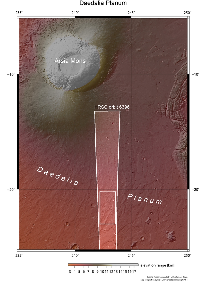
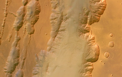
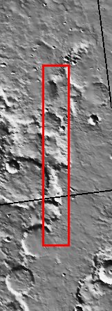
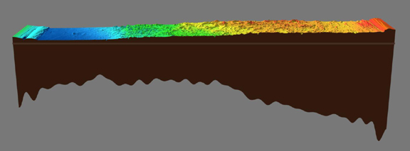
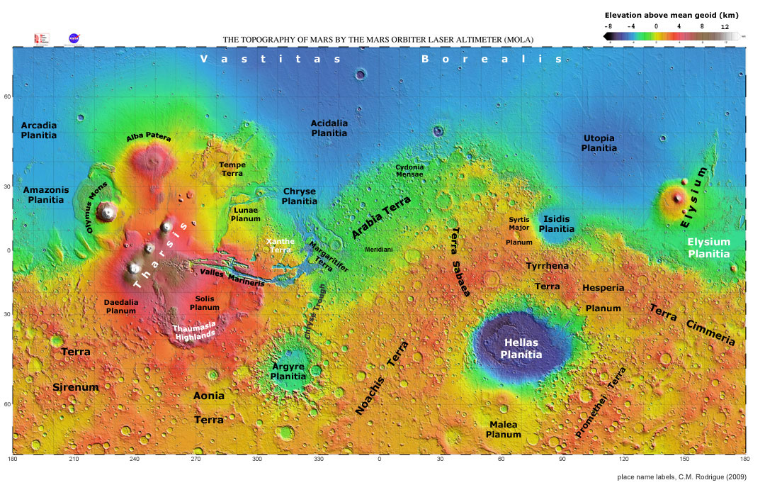
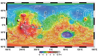