Lecture Notes for the Final
- Second order of relief: gigantic features and the dominant processes
shaping the martian surface
-
Mars' surface physiography shows conspicuous evidence of several geomorphic
processes: impacts and cratering, volcanism, rifting, glaciation, hydraulics,
and æolian processes.
-
These processes have created enormous landscape features, some visible with
telescopes from Earth, which constitute the second order of martian relief.
-
These features are between 1,000 km to 8,000 km in diameter or length: four
enormous impact basins, the other great volcanic rise, the Valles Marineris
rift system, the possible mega-slide of Thaumasia, the polar ice caps, the
Chryse Trough drainage system, and the Syrtis Major wind-cleared basalt
region.
-
Together with the first order great crustal dichotomy, these second order
features provide a framework on which to hang an increasingly detailed mental
map of Mars.
-
The great impact basins
- Much of Mars is cratered, but there are four impact craters that stand
out by their tremendous size, ranging from 1,500 km to 3,300 km in diameter.
They also feature positive gravitational anomalies (mass concentrations, or
mascons, coïnciding with topographic lows), which seem counterintuitive,
given the tremendous excavation of mass from them.
-
Hellas Planitia
- This crater spans about 50° of longitude and 30° of latitude,
centered about -42° at 70° E.
- It is some 2,300 km across and 8 km deep relative to the surrounding
countryside (about 4 km below the geoid)
- Striking thought: If all the material excavated by the impactor that
created Hellas were sifted evenly all across the contiguous continental United
States and slowly built up, it would cover us up to a depth of 3.5 km or so
- Indeed, the material blasted out of Hellas accounts for a large share of
the higher elevation of the Southern Highlands over the Northern Lowlands,
according to Arden Albee (2000, Annual Reviews of Earth and Planetary
Science). It amounts to several hundred kilometers in width by some 2 km
in depth.
- This argument is what got me to thinking that, if Hellas could disgorge
this much ejecta, wouldn't the Northern Lowlands impactor have deposited
vastly more ejecta, perhaps accounting for a very significant share of the
raised elevation of the Southern Highlands?
- The Hellas event is believed to date from the end of the Noachian era
(which ran from the beginning of the planet's coalescence to maybe 3.8 billion
BP).
- When an impactor of this size hits, it vaporizes and melts solid rock.
- Magma containing iron minerals (which the basalts of Mars' Southern
Highlands have a lot of) aligns with the then prevailing magnetic field
- Hellas shows no such remanent magnetization, so it formed after the
collapse of the
Martian magnetic field
- The crust is very thin here, < 10 km thick, perhaps as little as 7 km,
related both to the explosive excavation and to the rebounding of the mantle
afterwards.
- Hellas went through extensive reworking after its excavation:
- It may have contained a great inland sea, with a volume about two thirds
that of the proposed Northern Lowlands ocean.
- The floor deposits are largely Hesperian in age (younger than the
Noachian times of its formation, but younger than the Amazonian age of the
Northern Lowlands surface)
- Hellas shows all sorts of interesting erosional and depositional
landforms expressing this complex geological history:
- Depositional:
- Volcanic wrinkle ridges and pyroclastic flows
- Mass wasting/landsliding
- Fluvial alluvial fans
- Lacustrine/marine layered deposits
- Æolian dunes
- Ground ice or glaciers
- Erosional:
- Fluvial outflow channels
- Lacustrine/marine shorelines
- Æolian yardangs
- Argyre Planitia
- Another girnormous crater centered around -49° lat. and 318° E.
lon.
- It's not as large as Hellas, with a diameter about 1,800 km and a depth
of 5 km
- It is visually distinctive due to the rugged mountain massifs that form
ring and radial fretting patterns around the floor of the crater.
- The radial pattern is enhanced by five major channels flowing into and
out of the basin: four entering from the south and one flowing out of the
north rim.
- Muddying my tidy nested regionalization scheme, apparently, Argyre, a
second order feature, is involved in another second order feature I'll discuss
later, a tremendous seemingly fluvial system draining from beneath
the south polar cap through a chain of crater lakes and river channels leading
to Ares Vallis and Chryse Planitia.
- Many of the same erosional and depositional features seen in Hellas
Planitia can be found in Argyre Planitia
- Of the four great impact basins, the floor of Argyre is the oldest,
judging from the superposed crater density, probably late Noachian in age.
- Isidis Planitia
- Isidis is the third of the great impact basins found in the Southern
Highlands, but, unlike the previous two, it is found right on the first order
crustal dichotomy border, again kind of messing up my tidy "orders of relief"
scheme.
- It's centered roughly at 15° at 90° E.
- Very distinctively, Isidis has almost no remnant of its northern and
northeastern rim structure: The crater opens out onto the Northern Lowlands
over a gradual rise of only about 500-600 m from the lowest point of the
crater flow.
- It also has the thinnest crust of the four great craters, ~6 km.
-
It also features a higher level of post-impact fill, nearly 3 km deep, giving
it the flattest floor of the three, with a slope about 0.015°, tilting
down toward the southwest and then reversing to form a smooth but steeper
slope rising to the southwest into Syrtis Major.
- There has been energetic debate about what the nature of that flat fill
is.
- One group argues that this is a basalt flow from the Nili and Meroë
Patera volcanoes in the Syrtis Major region to the west the likeliest sources
- Others point out that most of the basin tilts downward toward the
southwest, so that would be weird if this were lava from those volcanoes.
- Another argument against the Nili and Meroë Patera volcanoes is that
their lavas have much greater surface roughness than the Isidis fill.
- There's been speculation that the fill might be catastrophic debris flows
triggered by Syrtis Major volcanic dikes interacting with ice-rich soils,
particularly ices rich in carbon dioxide. That interaction would trigger an
explosive outflow, perhaps destroying the crater's northeastern rim.
- Going against that idea, though, is the lack of chaos terrain and
channeled outflows of the sort we see farther west in the borderlands of
Tharsis.
- Still others think that, however that northeast rim was broken, its
failure allowed a marine intrusion from the posited Northern Lowlands ocean,
kind of a big lagoon, complete with smooth marine deposits.
- The various positions on this debate are summarized in Hiesinger and
Head, 2004, Lunar and Planetary Science Conference.
- Like the previously discussed craters, Isidis has a very complex
geological history: volcanic, marine, permafrost, mass wasting, and
æolian features
- Among these are a lot of dunes forming fields with ripple structures
- It has a high density of smaller craters. It is probably younger than
Hellas, though, basically puncturing its annular ring.
- However, many of these craters are eroded mounds with pits at the top
- Their appearance suggests that there was once some kind of sediment or
other filling in Isidis even higher than it is now, which was then smacked by
craters, which consolidated the areas around the impacts under the ejecta
blankets.
- Later, erosion (wind?) removed whatever these beds were, leaving the
consolidated crater rims to stick out more and more prominently above the
lowering floor: rampart craters.
- This intriguing crater is where Beagle 2 was to land on 25 December 2003
- Utopia Planitia
- A lava plain in the northern lowlands, located roughly at the antipode
from Argyre, about 46° lat. and 119° E lon.
- This is where Viking 2 landed in 1976.
- This is where Viking 2 recorded the formation of thin frost layers on
rock and
soil, which may form when CO2 in the atmosphere freezes out,
attaches to dust particles (themselves the condensation nuclei for water), and
then settle down like a kind of fog frost
- The consensus now is that Utopia Planitia is a humongous crater buried in
whatever it is that resurfaced the Northern Lowlands. This was first proposed
in 1989, when G.E. McGill published an article in JGR arguing from
geomorphic evidence that there was some kind of circular structure buried in
the Northern Lowlands. His argument has basically received increasing support
with every
new data source collected on it, though there are still some holdouts saying
that not all alternative explanations have been systematically ruled out.
- There are odd circular grabens on that Northern Lowlands surface
material.
- These look almost like the draping and sagging and fracturing of some
layered material over buried crater structures
- Mars Express has ferreted out buried craters on Chryse Planitia
- This would be consistent with ocean sediments in an argument by Debra
Buczkowski and George McGill in 2002
- Might that consistency not preclude low viscosity lavas?
- If this is, indeed, a crater, it is the largest of the four discussed
here as second order features at 3,300 km across (conservative estimate) to
4,700 km across (more inclusive definition).
- It is, moreover, covered by the buried "quasi circular depressions" that
MOLA and Mars Express have found all over the Northern Lowlands, revealing an
ancient surface under that smooth resurfacing. Since, the resurfacing is
newer, Amazonian material and the QCD are necessarily much older (probably
Noachian like much of the Southern Highlands), then something buried under
them is older still.
- Utopia is far from the equator and gives a lot of evidence of
ice-related features and processes:
- Viking 2 documented the first evidence for the frequent formation and
sublimation of frost and ice fogs.
- There's patterned ground, the polygons often seen on Earth over
permafrost.
- There's evidence of sublimation of subsurface ice in the form of
scalloped pits and thermokarst.
- There are lobate debris aprons of the sort you see in solifluction
affected Arctic terrain.
- Pedestal craters are found here and in other high latitude locations: An
impact crater sits at the top of a mesa several times wider than it is,
surrounded by a steep scarp that perches the whole landform dozens of meters
above the surrounding plains. These have been interpreted as impact-hardened
ground and ejecta blankets set in a soil substrate susceptible to æolian
erosion.
-
The other great volcanic rise: Elysium Rise
-
Another huge rise, dwarfed only by the sheer scale of Tharsis
-
"Only" 2,000 km
-
"Only" 6 km thick
-
Also houses multiple volcanoes:
-
Elysium Mons on the west central side of the rise (12.5 km high)
-
Albor Tholus to the southeast (4.5 km high, with a 3 km deep caldera!)
-
Hecates Tholus to the northeast
-
Hecates may have been active at least as recently as 350 million BP and this
looks like an explosive event creating a flank caldera on the northwest side
of the volcano
- An article by a team led by Ernst Hauber, based on Mars Express HRSC
data, discusses an elongated depression running NE to SW at the bottom of the
northwest slop of the volcano (~45 km by 20 km)
- It contains some 50 m wide ridges that look like terminal moraines on
Earth
- Another, shorter depression is completely full of striated materials
running downslope and have some cracks perpendicular to them that look like
stuff that would be deposited in crevasses and then exposed as the glacier
melted or sublimed back
- There are steep sided valleys pouring out onto the top of the bigger
depression: Could these be hanging valleys carrying materials onto the top of
the "valley glacier"?
- These features have few craters on them, implying an age of something
like 100-ish million BP
- Similar features have been reported on the
northwest flanks of Olympus, Arsia, Pavonis, and Ascraeus, too
- Ice age?
-
Elysium may have erupted 20 million BP, meaning it could well be an active
volcano (error bars X 4 - 80 million BP to 5 million BP)
-
The "recent" vulcanism has put dust in the eye of the traditional theory that
Mars, being a dead planet with a cooled core, stopped being volcanically
active two billion years ago!
-
As with Hecates, Elysium may have been glaciated, but 5-24 million BP, judging
from glacial deposit features and crater counting on the Hecates flank caldera
and nearby depressions:
-
There is (and cannot be) stable ice at these low latitudes now.
-
Such glaciation suggests climate change on Mars and the timing coïncides
with a time of increased obliquity and seasonal extremes on Mars.
-
Again, tantalizing suggestions of an ice age on Mars
-
The great canyons: Valles Marineris
- Overview:
- Extensional rifting, related to the extensional stresses on the
Tharsis
Rise
- Pitting, which is another indicator of extensional strain -- thought to
reflect dilational faulting, which creates voids below, into which
unconsolidated surface regolith collapses
- Water or water mixtures in subsoil or, in Hoffman's argument, carbon
dioxide ices or mixtures
- Landslides
- Massive outflows, like jökulhaups on Earth when vulcanism-related
warming
hits a glacier or ground ice or when an ice dam or moraine dam liberates a
huge lake
- Not quite a canyon in the Earth sense, since the eastern end is higher
than the center
- Subsidiary chasmata
- Ius Chasma in the west on the south side (note the alcove-headed short
tributaries, so like groundwater-fed networks in arid regions in the American
Southwest)
- Melas Chasma in the middle on the south side, some 9 km below the edge of
the surrounding plains, shows some sulfates on its floor and sides, which
could indicate the presence of a lake here.
- Coprates Chasma to the east on the south side, the location of the
subsidence pits I showed you in discussing extensional stresses.
- Eos Chasma, the southern fork on the east side, shows patches of chaos
terrain toward the west and the kinds of braiding patterns and flow structures
that add to the impression that Valles Marineris once carried water, yet it
also contains a layer of exposed olivine toward the bottom, which weathers
rapidly in the presence of water. Perhaps Mars dried up quickly after the
olivine layer was exposed?
- Capri Chasma, the northern fork on the east side, has hæmatite
"blueberries" like those in Meridiani that Opportunity imaged. Hæmatite
is an iron (III) oxide ((Fe2O3) that can be formed from
prolonged exposure of iron to water.
- Tithonium Chasma in the west to the north of Ius shows deep layered
deposits of sulfates and iron oxides, suggestive of water alteration: The
layering basically goes all the way down the sides of the canyon for
kilometers. Could these indicate miles of sedimentary deposition?
- Candor Chasma in the center north of Melas and south of Ophir. It is
itself split into two sections, East Candor and West Candor. Calcium sulfate
and kieserite (hydrated magnesium sulfate, or MgSO4-H2O)
have been identified by the OMEGA spectrometer on Mars Express, and these are
commonly products of water alteration.
- Ophir Chasma is on the north end of the main Valles Marineris sequence of
chasmata. It features landslides on a stupendous scale.
- Ganges Chasma to the east north of Coprates/Eos/Capri, that "Rat Fink
hotrod" shaped canyon, where Lab 1 was situated. This canyon also shows
olivine, a mineral that alters very rapidly in the presence of water, so its
presence here goes against the impression of water alteration minerals in
other canyons (unless the climate drastically dried immediately after the
olivine layer was exposed).
- Juventae Chasma off to the northeast is an almost totally boxed in
canyon, with an exit to the north, at the head of Maja Valles, a major outflow
channel forming the boundary between Xanthe Terra and Lunæ Tera. It
contains a mountain about 2.5 km high, which is made of sulfate deposits. The
canyon shows a number of water-altered minerals.
- Hebes Chasma off to the northwest shows exposures of gypsum (a very soft
sulfate mineral, CaSO4-2H2O. It is an evaporite,
suggesting a wet phase in Mars' history.
- Echus Chasma to the immediate west of Hebes, forms the head of the
enormous Kasei Valles. It also shows a sickle-shaped dike. The vast
outpouring down Kasei Valles may have been triggered by dike formation, which
would catastrophically have liberated huge amounts of frozen groundwater.
-
Chryse Trough
- A large arc of locally depressed topography loosely rings the Tharsis
Rise, most likely the result of the loading of lava on the lithosphere below
the Tharsis volcanoes.
-
Timothy Parker in 1985 suggested that this depression east of Tharsis, dubbed
the Chryse Trough, might have housed an actual channel for catastrophic
flooding, comprising several tributary channels flowing from near the South
Polar Ice Cap into Argyre.
- From a presumed lake in Argyre, the flow would move through Uzboi Vallis
into a chain of smaller craters linked by channels that flowed into
Margaritifer Terra east of Valles Marineris. From there, drainage would move
into Chryse Planitia and the proposed northern lowlands ocean.
- The topographic resolution of even the best imagery was too coarse and
the elevational uncertainty too great for testing of the direction of flows in
the proposed system until MOLA data arrived (1997-2006).
- The resulting high resolution topographical information seems to confirm
the existence of an 8,000 km drainage system
- Two valley networks originate in Dorsa Argentea around 320°. near the
South Polar Cap and, along with a third network, lead to Argyre Planitia.
- An outflow channel with steep walls and great depth, Uzboi Vallis, runs
out of Argyre to the northeast, cutting into the rim of Holden Crater, where
signs of a delta or alluvial fan are found.
- The northeast rim of Holden Crater is blunted and forms a ramp leading
down to Ladon Basin where the channel structure disappears into what may have
been a lake.
- The channel morphology re-appears leading out of Ladon Basin to the
northeast into large outflow channels in Margaritifer Terra.
- These channels, Margaritifer Valles, then debouch into Chryse Planitia,
forming a possible delta structure at the higher of Parker's two proposed
shorelines, the Arabia shoreline.
- If, in fact, this system did move water or other fluids from the area
around the South Polar Cap to Chryse Planitia, even as a sporadic and perhaps
not always continuously connected drainage, at some 8,000 km in length, the
Chryse Trough would constitute the longest fluvial network in the solar
system.
-
Massive outflow: Kasei Valles
- Kasei Valles is the enormous channel that seems to erupt out of Echus
Chasma to the north of Valles Marineris, flow due north, and then make a
nearly right angle turn to divide into two main branches that debouch into
Chryse Planitia to the northeast.
- Its northern channels are fringed with chaos terrain, too, such as Sacra
Fossae.
- The channel could carry a staggering amount of fluid, dwarfing the
outflow channel in Ares Valles, not to mention the most gigantic
jökulhlaup floods on Earth (e.g., the Missoula and the Bonneville
floods).
- Kasei Valles cuts across the Hesperian lavas of eastern Tharsis and of
Lunæ Planum (forming the western boundary of Lunæ Planum).
- There is evidence of subsequent lava or pyroclastic flows into Kasei
Valles on its western edge, creating a marked softening of the edge there.
This flow may have come from Tharsis Tholus, the easternmost volcano of
Tharsis Rise.
-
Thaumasia Block: Plate or Megalandslide?
- A distinctive wedge- or lozenge-shaped plateau region on the
southeasternmost part
of the Tharsis Rise
- To its north is Valles Marineris (it is sometimes bounded by Valles
Marineris, though some consider it to extend just beyond Vallis Marineris)
- To its south lie the Thaumasia Highlands, the only folded/faulted
mountain ranges on Mars that resemble the most common types of mountains on
Earth.
- These continue east as Coprates Rise.
- Claritas Fossæ lie to the west between Tharsis Montes/Dædalia
Planum and the Thaumasia feature. Claritas Fossæ run about 1,800 km and
the terrain is fractures by a series of north-south striking normal faults and
grabens, some of them offset, reflecting tensional and some shear stress
associated with the uplift of Tharsis.
- North of Claritas Fossæ and west of Valles Marineris is the
distinctive Noctis Labyrinthus chaotic terrain.
- Internally, Thaumasia is divided into:
- Syria Planum, the highest elevation portion at the northwest corner of
Thaumasia, enclosed within the arch of Noctis Labyrinthus and north of the
beginnings of Claritas Fossæ
- Sinai Planum lies to the east of Syria PLanum, south of the junction of
Noctis Labythinthus and Valles Marineris
- Solis Planum is a large, flat expanse dominating the center of Thaumasia,
characterized by northeast-southwest trending wrinkle ridges, indicative of
compressional stress crumpling the thin lava beds of Solis, stresses from the
uplift of the Syria Planum area to the northwest
- Thaumasia Planum or Thaumasia Minor, is a circular planum south of
Coprates Chasma in Valles Marineris and west of the Coprates Rise. There's
some evidence that it contains a large buried crater: http://plate-
tectonic.narod.ru/watters_2006-02-01123a_figure4_l.jpg.
- Analogies with Earth plate tectonic features early suggested incipient
plate tectonics, with Valles Marineris the rift zone and possible divergent
boundary and Thaumasia Highlands and Coprates Rise the subduction zone
features.
-
Plate tectonics even of the most incipient variety, is not the
consensus view today, and most workers consider Mars to be a one-plate planet
with
tectonic uplift concentrated almost exclusively in a single mantle plume
rising up under Tharsis.
-
Plate tectonics is not completely out of the picture, however. Recent work by
An Yin (2012) argues that the rounded southeastern boundary of Melas Chasma
is, in fact, a large crater. The crater is missing its northern rim. Yin
points to a rounded structure in northwestern Melas Chasma that may be its
displaced northern rim. If so, there has been about 150 km of left-lateral
movement along what he argues is a shear fault boundary, like our own San
Andreas Fault. Could, then, Valles Marineris divide adjacent plates, the way
the San Andreas divides the Pacific and North American plates?
- A recent argument by Montgomery et al. in 2009 proposed that
Thaumasia constitutes a "mega-slide" resulting from "thin-skinned" deformation
of multiple shallow layers of lava on top of deeply impact shattered
regolith. This regolith contains mixtures, not only of basaltic impact
gardening debris, but of ices and evaporite beds as well.
- A lot of the subsurface is Noachian, meaning it could well have had
streams and ponds with evaporite beds forming in any local depressions.
- Evaporites often concentrate salts, and salts form materials that are
much less resistant to shear stresses than regular crustal rocks are and
capable of viscous flow in response to stresses (especially if water or brine
gets in there).
- Magma intrusion under subterranean ices, especially in Syria Planum
closest to Tharsis Montes, could create highly confined supercritical aquifers
(water unable to boil because of the confinement of subterranean water under
high pressure). A bomb waiting to go off.
- Shear-induced detachments could allow movement of these thin layers,
while the size of Thaumasia (and the low gravity of Mars and the low angle of
Thaumasia) implies this process of detachment must go down quite far, to
enable deep detachments to let the whole Thaumasia complex begin to move.
- Meanwhile, Tharsis, the source of subterranean heat, would continue its
upward movement, creating tremendous tensional stress around Thaumasia's
highest point, Syria Planum. That would account for the normal faulting seen
around Noctis Labyrinthus and the original rifting of Valles Marineris, as
well as the grabens of Claritas Fossæ and their slight right lateral
motion (as Thaumasia began to detach and slide southward).
- The creation of some of these rifts could explosively liberate the
trapped supercritical fluids in the subsurface, possibly accounting for the
megaoutflows associated with Valles Marineris and the chaos terrain of the
undermined Noctis Labyrinthus.
- As the megaslide moved along its various detachments, crumpling would
occur in the thin lava layers as they experienced compressional stress between
the moving slide and the stationary terrains of Aonia Terra and Noachis Terra
to the south and east, respectively. This compressional stress is visible in
the many wrinkle ridges in the middle and lower reaches of the proposed
megaslide, running in quasi-parallel "waves" from east-northeast to
west-southwest. You can easily see them in Google Mars, through much of Solis
Planum and Thaumasia Planum to the immediate east of Solis Planum.
- The toe of the proposed megaslide would be the folded and thrust-faulted
mountain ranges of the Thaumasia Highlands and Coprates Rise.
- So, the large Thaumasia "lozenge" that is so conspicuous in MOLA maps
might be a second order expression of yet another mega geological process:
landsliding on an epic scale.
-
END 03/18/15
- Syrtis Major "Blue Scorpion" and æolian processes
- This feature was the first martian landform recorded in a sketch map
drawn by Christiaan Huygens in 1659 (and, debatably, as early as 1636 by
Francisco Fontana)
- It is that large, triangular low albedo object that dominates the area
west of Isidis Planitia and north of Hellas Planitia, connected loosely to a
band of low albedo surfaces in the Southern Highlands.
- The feature is persistent though the edges shift around through time.
- Its dark color and stability invited early speculations about an ocean
or vegetation-dominated area, seeming greenish or blueish from Earth in
contrast to the bright orange/ocher light albedo areas surrounding it.
- Orbiter imagery has revealed it as a volcanic province (lavas from Nili
Patera and Meroë Patera in Syrtis Major Planum, which has been swept
clean of dust by a prevailing northeast wind (winds are named for the
direction from which they blow).
- One of the striking demonstrations of this prevailing wind pattern is
imagery of craters on the lava, which feature bright tails of dust deposited
in the lee of the crater rims: Winds deflecting around an obstacle rejoin
leeward of it, creating cross-interference, which reduces the resultant
velocity of the wind, and this reduces its carrying capacity for supporting
dust, which then deposits in the low-energy zone leeward of the obstacle.
- This persistent prevailing wind seems related to the global circulation
of Mars as distorted by topographic effects (deflection of the global
circulation's wind systems by the Tharsis Rise).
-
Polar ice caps
- Northern cap:
- The ice cap itsel is about 1,000 km in diameter.
- The North Polar Cap and the Planum Boreum plateau structure underlying it
cover approximately 800,000 km2 and, with thickness ranging to
nearly 3 km in places, the ice cap volume amounts to somewhere between 1.2 and
1.7 million cubic kilometers.
- Its extent varies seasonally and also over centuries with climate change.
- During the northern hemisphere fall and winter, the North Polar Cap is
obscured by hazes and clouds and even sometimes hurricane-like storm systems
that develop north of 50o, a cloud cover referred to as the polar hood.
- Through precipitation or through frost sublimation, carbon dioxide ice
on the ground expands to roughly 60o of latitude
- This ice cap is mainly composed of water ice, which dominates the
residual ice that persists through all seasons.
-
The water does sublime,
whenever summer temperatures get above 205 K (-68° C or -91° F), which
it sometimes does on the south-facing walls of the ice cap, which exaggerates
the steepness of the south-facing slopes.
- In the Northern Hemisphere winter, water freezes out of vapor, first at
the pole and then farther and farther out, to build the seasonal water ice
cover.
- Carbon dioxide sublimes around 150 K (-123° C or -190° F), so it
freezes out as frost as winter approaches, developing a seasonal carbon
dioxide veneer. This seasonal carbon dioxide ice extends out quite far from
the polar ice cap.
- During summer, first the carbon dioxide frost sublimates away entirely
and then some of the water ice does, too, noticeably shrinking the ice cap
during the Northern Hemisphere summer.
- This adds a significant pulse of carbon dioxide to the atmosphere in the
Northern Hemisphere winter, the partial pressure of which raises martian air
pressures quite significantly: There's nothing like this pressure pulse on
Earth.
- The Northern Hemisphere summer is
noticeably longer than the winter, so there's that much longer for air
temperatures to exceed 150 K and even 205 K, so it's not surprising that the
carbon dioxide veneer disappears and even some of the water ice sublimates.
- One of the weirdest features of the Northern ice cap, which has no
parallel on Earth, is the existence of deep chasmata in the ice.
- These are very deep and curve outward in a counterclockise spiraling
pattern.
- The largest is Chasma Boreale, which opens out from the ice cap about
300-320o E, where it is about 350 km wide and cuts back some 600 km ... and
spirals at an angle different from most of the others.
- These features are etched as much as a kilometer into the cap and often
their depth takes them below the elevation of the surrounding countryside.
- Their floors have lower albedo than the surrounding polar layered
deposits, suggesting that they may be traps for dust blown into them.
- Very oddly, though, they trend counterclockwise outward, while katabatic
winds generated by the polar high tend to spiral clockwise off the cap. One
of those martian "yes, but ..." moments.
- There is all kinds of speculation about what causes these weird features:
Wind erosion? Jökulhlaup erosion?
- Internal stratigraphy was revealed by the Shallow Radar (SHARAD) sensor
on board the Mars Reconnaissance Orbiter (MRO):
- Four laterally continuous concentrations of fine layers of dust
- Three homogeneous zones of nearly pure water ice
- A basal unit of æolian origin, comprised of dark sand-sized grains.
It is believed to be of Amazonian age, meaning the ice cap is no older than
the Early Amazonian.
- This layering of pure water ice and dusty ice is a record of Amazonian
climate change and coring it would be of intense interest to future human
expeditions to Mars.
- Southern cap is quite different from the northern cap.
- Much smaller, about 350 km in diameter, but it is somewhat thicker,
getting over 3 km thick in places.
- The seasonal carbon dioxide frost extends farther out than seen in the
Northern Polar Cap, though: It gets down to about -45°
- Located on the Southern Highlands, it is about 6 km higher up than the
North Polar Cap, which means that it gets colder (think of lapse rates up a
mountain on Earth).
- The Southern Hemisphere winter is noticeably longer than the summer
because of the planet's great orbital eccentricity, which means Mars is moving
relatively slowly at aphelion, protracting winter.
- Aphelion is 121% as far from the Sun as perihelion, which itself means a
drastically colder winter than experienced in the Northern Hemisphere.
- Also, the Southern Hemisphere summer features more dust devils and dust
storms than the Northern Hemiosphere summer, meaning the Southern Hemisphere
summer is dustier and the surface is slightly shadier, also meaning the summer
is cooler.
- This means that, even in the relatively short Southern Hemisphere summer,
temperatures are not going to get above 150 K for long enough to sublimate
away all of the carbon dioxide ice. The permanent carbon dioxide ice remains
about 8 m thick through the summer.
- Suspicions that there was water ice below the residual carbon dioxide ice
cap were affirmed by ESA's Mars Express Minerological Mapping Spectrometer or
OMEGA and NASA's Mars Odyssey Thermal Emission Imaging System or THEMIS).
- Sublimation pits have long been observed on the South Polar Cap, where
carbon dioxide sublimates explosively in geysers, sometimes pulling dust up
with it.
- These steep-sided pits consistently show flat floors about 8 m below the
surface ice.
- These floors evidence water ice.
- So, the South Polar Cap has a residual carbon dioxide cover about 8 m
thick on top of a permanent water ice core.
- This water ice core probably saw some basal melting in the past, as seen
in imagery of stream channels emerging from below the ice.
- This creates at least some plausibility for the Argyre to Ares fluvial
system, or Chryse Trough system proposed by Timothy Parker.
- The South Pole Cap dominates the large air pressure swings in the
atmosphere.
- At the Viking 1 landing site in Chryse Planitia, air pressure varied
annually over a range from 6.9 to 9 hectopascals or millibars, something like
a 30% increase.
- Air pressure would go up like crazy in the Viking 1 fall and winter, back
down somewhat in spring, go up in late spring/early summer, and drop like a
rock in late summer.
- This coïncides with the cycle of sublimation of a lot of carbon
dioxide off the South Pole Cap in its spring and summer and the migration of
that CO2 to the North Polar Cap. The same thing would happen in
the North Polar Cap's spring and summer, but the effect was smaller.
- So, the southern cap has a stronger effect on the semi-annual march of
air pressures on Mars, because the CO2 ice is more extensive than
on the northern cap, and the winter there is longer and colder than the
northern cap due to the exaggerated ellipticity of the planet's orbit
interacting with the marked tilt in the axis.
- END 02/26/14
- Third order of relief: Variations in crater density
-
The third order of relief includes regions smaller in extent than most of the
second order features, though some are very large, as large or larger than
many second order features already described.
- As mentioned earlier, they do not "nest" within second order features
(though they do within the first order), as I reserved the second order as the
level of really conspicuous large features of the planet.
-
Third order features are broad regions, but they are not visually conspicuous
in the way of, say, Syrtis Major or the seasonal polar ice caps.
-
They typically range in diameter from ~1,000 km (e.g., Meridiani Planum) to
5,500 km (e.g., Noachis Terra).
- They are all named as:
- Terra ("extensive land mass")
- Planum ("a plateau or high plain")
- Planitia ("a lowland or low-lying plain")
-
It is at this order that we can clearly see the variations in crater density,
size, and condition, which are used to establish relative dating on the
martian surface. In discussing the third order of relief, then, I'll first
cover the crater-counting system of relative aging and then the epochs of
martian geology. Each epoch will be used to frame the third order landscape
features.
-
Crater-counting
- The idea here is that the longer a planetary surface has been around,
the more "opportunity" it has to be the target of solar system debris.
- This debris consists of the small dust grains to planet-sized objects
that have accreted, largely through gravitational attraction, out of the
planetary gas and dust nebula and disk that surrounds the proto-sun and sun.
- There is a magnitude-frequency relationship here, similar to what we see
with many other hazards: The smaller impact events are vastly more common
than the larger ones.
- The ideal size-frequency distribution follows a power law pattern, that
is something along the lines of Y = aX -b, or, alternatively, log Y
= log a - b(log X), where Y = the number of craters in a given size range or
larger; X = crater diameters; a = the Y intercept (a calculated constant); and
b = the slope of the curve (the other calculated constant).
- Doing this as a log-log chart, the association, ideally, forms a
straight line, with slope b.
- The older the surface is, the higher a will be. The curve for an
older
surface will have the same slope but its height on the chart will be greater.
- Past a certain point, though, you reach saturation, a level of
bombardment so severe, a landscape so old, that there is literally no more
room for a new crater: Each new crater necessarily obliterates traces of
older craters.
- Once saturation is reached, it is no longer possible to say that one
saturated landscape is older or younger than another saturated landscape.
Once saturation is reached, all you can say is that surface is crazy-old, on
Mars, over 4 billion years old.
- To do a crater count study, you need to calculate the area of your study
area and normalize it (so that counts can be scaled to a common areal base):
A common system (Hartmann and Neukum 2004) uses a square kilometer.
- Then, you identify every crater on your image, recording its diameter in
meters or kilometers.
- Then, you establish size bins: The common standard is an X axis with
each bin's upper boundary equal to the lower boundary times the square root of
2. So, starting at 1 km, the next bin boundary would be
1 *
√2, or 1.414. The next
one would be 1.414 *
√2, or 2. The next one
would be 2 *
√2, or 2.828, followed by
2.828 *
√2, or 4, and so on.
- After you have your size bins, you compare each of your crater diameter
measurements to your bins and count up the craters that fall within each of
the bins and then convert the counts so that they are proportional to 1
km2, instead of the original size of your actual study area. So,
if your study area were 100 km2, you'd divide your counts by 100
(and, yes, it seems weird to count the number of 5 km wide craters in a 1
km2 standardized area).
- That done, you plot the adjusted number of craters in each bin on the
Hartmann-Neukum "isochron" graph, available at http://www.psi.edu/research/mgs/template2008.JPG.
- You'll find that the pattern of dots you plot at the intersection of the
middle of the bins and the number of craters per square kilometer will align
roughly with one of the dotted or solid lines on the isochron plot. This can
be very roughly: Typically, the rightmost dots, especially, are more widely
divergent from the isochrons. The counts in the larger bins are smaller and
smaller, so you get statistical small-sample effects that allow the dots to
range pretty far afield.
-
The
dotted lines are labelled with years ago (y = years; My = millions of years;
Gy = gigayears or billions of years).
- The long, straight solid line is saturation somewhere past 4 Gy. The
longer of the two short solid lines represents the boundary between the
Noachian Epoch and the Hesperian and the shorter, lower of the two short lines
represents the boundary between the Hesperian and the Amazonian (about which,
later).
- By looking at the height of the line your craters align with, you can
estimate the relative age of your study area (Noachian, Hesperian, or
Amazonian) and put some constraints on the absolute age of that surface, based
on an elaborate adjustment of lunar cratering rates with corrections for Mars
location in the solar system, its greater gravity, and its atmosphere.
- There are a few "plot complications" with the use of the crater magnitude
and frequency distribution for the estimation of absolute ages on Mars.
- If you look very closely at the dotted isochrons, you will see that they
do not form completely straight lines: They turn down somewhere around 64 km.
This reflects the drop in the supply of humongous potential impactors after
about 3.7 billion years ago, at the end of the Late Heavy Bombardment. The
LHB is a point of some controversy:
-
Did it simply mark the end of the era of
accretion and the removal of available big impactors by their making
themselves unavailable by, well, impacting into something
in the solar system?
-
Was there a tumultuous and dramatic increase in the
number of big items stirred up in the solar system about 4.1 to 3.7 billion
years ago (perhaps by the movement outward of the outer two giant gas planets
at that time)?
-
The exact meaning of the LHB is controversial but its existence is
not: Things really quieted down in the inner solar system after about 3.8 or
3.7 billion years ago.
- If you look at the other end of the X axis, you'll see a much steeper
turn upward at roughly (and variably) 1 km in crater diamter. This has really
been controversial.
-
Some argue that there really is a break in the size of potential impactors,
because there really is a qualitative break in the numbers
of smaller objects.
-
Others suspect that the upward break in the curves
reflects secondary impacts: Ejecta that lands at various distances from the
primary crater, creating craters of their own.
-
There's a whole cottage industry in trying to figure out ways of
differentiating secondary craters from primary ones just to get a handle on
how many of them there are and how their presence may distort estimated ages
of a surface.
- They may have different shapes or different depth to diameter relations
than primaries because they would be coming in at less than supersonic speeds
(but that is true mainly for the secondaries that fall close in; those that
get tossed out a far way may well attain very high velocities coming back to
ground).
- They seem to have a propensity for falling in distinct lines or rays.
Fresh craters generate rays of finer ejected materials interspersed with
bigger objects. The rays may erode away on Mars but the alignments of the
secondary craters may preserve that rayed appearance (this is the subject of
my own research on Mars, using statistical techniques to pick out potential
alignments of craters that might identify secondaries).
- If you look still farther to the left of the X axis, you'll notice yet
another inflection point in the isochrons around 10-12 m, where the lines
curve back down a bit. This probably reflects one or more of the following:
- the differential susceptibility of
smaller craters to obscuring by erosional and depositional processes
- the greater susceptibility of smaller objects to ablation
and shattering en route through the martian atmosphere
- resolution issues -- some craters are so small that they may not be
discernible, even on a high resolution image.
- So, power law mathematics are a great starting point, but Mars doesn't
completely coöperate with the simplicity of mathematics. The power law
seems to work with a slope of -1.8 or 2.0 for most martian surfaces for
craters with diameters in the ~1 km to ~64 km size range. Outside that range,
b would be larger and of different magnitudes at either end of the X scale
(about -3.82 for craters < ~1 km; about -2.2 for those larger than ~64
km) .
- Neukum tried to get around this by using higher order polynomial
modelling, but he and Hartmann reconciled their different approaches to
develop that isochron chart linked above. So, there's now a more or less
standardized approach to calculating relative ages and constraining absolute
ages, but there remain all kinds of controversies over secondary cratering.
- So, variations in crater density and size distributions is converted into
a periodization scheme for Mars. Unfortunately, the scheme most commonly used
maddeningly departs from the system developed for geological time on Earth.
Here's a quick overview of geological time and rock units on Earth.
- A distinction is made between geological time and geological rock units:
Geochronology and chronostratigraphy.
- At the coarsest level is the eon time unit, which is associated
with eonothem rock units. On Earth, there are four of these: Hadean (planet
formation to ~4 Ga), Archean (~4 Ga to 2.5 Ga), Proterozoic (2.5 Ga to ~542
Ma), and Phanerozoic (~542 Ma to present).
- These eons/eonothems are broken down into eras and corresponding
eonothems, such as the Palæozoic, Mesozoic, and Cenozoic within the
Phanerozoic eon/eonothem.
- Eons/eonothems are broken down into periods and the corresponding
systems, and some of these are differentiated into subperiods and
subsystems. So, for example, we have the Tertiary and the Quaternary
periods/systems within the Cenozoic era/erathem. The Tertiary is divided into
the Palæogene and the Neogene subperiods/subsystems.
- Periods/systems and, where they exist, subperiods/subsystems, are further
subdivided into epochs or the corresponding rock series (such as our
own Holocene Epoch [from ~11,500 BP] and the Pleistocene Epoch from 1.8 Ma to
~11,500 BP), which fit within the Quaternary Period/System (which doesn't have
subperiods/subsystems).
- Some periods are subdivided even further into ages or the
corresponding rock stages (e.g., the Calabrian or late Pleistocene and
the Gelasian or early Pleistocene).
- There are some inconsistencies and arguments, but the general pattern of
eons, eras, periods, epochs, and ages is widely recognized. Here is a link to
a USGS geological time scale: Theiikian Era: dominated by acidic water chemistry, as a result of the
massive volcanism of the later Noachian and early to middle Hesperian.
Volcanic activity ejected massive amounts of sulfur dioxide into Mars'
atmosphere, which would interact with water to produce sulfuric acid,
drastically acidifying surface and subsurface waters.
- Siderikian Era: dominated by æolian processes and oxidative
geochemistry, resulting in the production of anhydrous iron oxides. This was
a time of progressive loss of surface waters and most of the atmosphere after
the collapse of the planetary magnetic field. Water photodissociated in the
atmosphere, freeing its hydrogen to scoot off into space from the exosphere
and drawing the heavier oxygen to bind with iron-bearing minerals ("rust") in
dry conditions. In what follows, we'll use the traditional crater-counting
periodization but with attention paid to the geochemical issues at the heart
of the Bibring et al. system.
Noachian surfaces: The oldest
- From the earliest formation of the planet through the gravitational
accretion, collision, and consolidation of planetesimals, asteroids, comets,
meteoroids, and dust.
-
Some people are dividing the traditionally understood
Noachian into the "pre-Noachian" and the Noachian proper, with the
pre-Noachian reserved for the time of planetary accretion, differentiation,
and development of the planetary magnetic field. These folks would end the
pre-Noachian at the point where crater saturation doesn't allow you to discern
really old surfaces, a time by which the dynamo had clearly shut down (the
time of the Hellas and other huge impacts).
- Traditionally, though, the whole period from the time of the planet's
origins to the end of the Late Heavy Bombardment is referred to as the
Noachian. So, the Noachian includes:
- The kinetic, compressional, and radioactive heating of the accreted
materials
- Differentiation begins with melting of these materials and the "iron
event," when iron, melting first, began to drift in blobs toward the center of
the planet, pulling some siderophiles with it (particularly nickel).
- Formation of the mantle magma ocean.
- Formation of a crust on top of the magma ocean, in Mars' case, apparently
quite a thick one, for reasons unknown.
- Mantle overturn because of the gravitational instability created when
magnesium-rich olivine cumulates that crystallized out first at the hottest
temperatures were overlain by denser iron-rich olivine cumulates that
crystallized out later at a somewhat cooler temperature.
- Initiation of the planetary magnetic field through motion in the outer,
liquid iron-dominated core.
- The sustained bombardment of the differentiated planets as the solar
sys once part of igneous and metamorphic rocks.
-
Zircon contains some uranium, thorium, and lead, the ratios among which has
allowed them to be
radiometrically dated to as old as 4.4 billion years on Earth, in the case of
the Jack Hills zircons from Australia!).
-
There's been a controversy more recently about the age of actual mafic rocks
in Canada that might be as old as these zircons: the Nuvvuagittuq greenstone
belt just east of Hudson Bay in northern Province Québec. These have
been dated to 4.4 Gya but the results are contested with claims that they're
no older than a "mere" 3.8 billion years old.
-
So, where on
Earth Hadean eon materials consist of a very few zircon grains and a
controversial claim for Canadian greenstones, on Mars,
roughly 40% of the planetary surface dates back to the comparable Noachian
(Barlow 2010). If you're on campus or logged into the library from home, you
can view Barlow's map of martian age distibutions here: http://bulletin.geoscienceworld.org.mcc1.library.csulb.edu/content/122/5-6/644/F8.large.jpg.
-
So, while Mars is geologically active, it's nowhere near the level of activity
seen on Earth with its plate tectonism, and that has allowed the preservation
of ancient surfaces on Mars and their obliteration on Earth (except for those
zircons and maybe the Canadian greenstones)
- The constraint on the Noanchian timeframe is based on analysis and dating
of Moon rocks from similarly cratered surfaces brought back to Earth by
Apollo.
- This is a fairly elaborate reasoning process. Rocks were taken back to
Earth from the Moon by the Apollo astronauts from regions that had been
previously relative-dated by crater-counting techniques. The returned rocks,
then, allowed for an absolute date to be assigned to surfaces of previously
described as of particular relative dates.
- Then, the size-frequency curve for the Moon had to be calibrated for use
on martian surfaces, factoring in Mars' atmosphere (which would both destroy
more of the smaller objects and slightly reduce their incoming velocity),
Mars' location closer to the putative source of orbiting debris in the solar
system (closer to the asteroid belt and to Jupiter, the gravity of which
dislodges objects and puts them on new orbits, including orbits that intersect
the inner solar system bodies).
- You can get an overview of the Moon to Mars isochron correction system
(optional link for the curious: http://www.psi.edu/research/mgs/isochron.html).
- Characteristics of Noachian surfaces
- Noachian surfaces on Mars are intensely cratered: craters on top
of
craters to the point that it becomes challenging to pick out which ones are
superposed on which others
- Noachian surfaces also show a great diversity of crater sizes,
with some
big craters mixed in with medium and small ones
- Noachian craters, too, show a lot of geomorphic
reworking:
- very distinctive softening of the rims, as though they'd sagged and
spread out.
- hardened ejecta blankets with that "wet splat" look, sometimes with two
or more layers of flowing ejecta, sometimes with the kinds of striations
produced by very rapid and fluidized movement, often ending in a rampart edge.
- some of these craters were clearly buried by wind or water deposits, and
then subsequently re-exposed by erosion as pedestal craters perched like
crater-dented mesas high above the remaining landscape level.
- floors flattened by the deposition of alluvial, lacustrine,
marine, or æolian materials in them: You do not see that on the Moon,
which lacks such familiar geological activities as wind and water erosion,
transport, and deposition.
- There was quite a bit of this geological work back in Noachian times:
- Valley networks are found almost exclusively on Noachian surfaces,
showing fluvial action by what is more and more accepted as water, even
precipitation-fed channelization.
- There was some early and distinctive vulcanism in the highlands,
featuring plains formed from very low viscosity lavas (flood basalts,
possibly emanating from long rupes or fossæ), small cones, and very
shallow-sided vent-volcano edifices (pateræ).
- Later in the Noachian, volcanic activity became increasingly concentrated
in the two great volcanic rises, Tharsis and Elysium, which built up at this
time. The viscosity of lavas associated with the later volcanism allowed the
construction of very tall shield edifices and, in some cases, ashy eruptions
were part of the mix, which allowed the construction of steep sided tholi.
- The Late Noachian saw such extensive and massive volcanism that global
geochemistry was drastically changed.
-
Early Noachian geochemistry was dominated by phyllosilicate chemistry
(alteration of basalts in water to liberate silicas, including the kind of one
silicon/four oxygen tetrahedrons that produce micas, talcs, and clays).
-
Late Noachian and Early Hesperian geochemistry shows a strong sulfate
signal, as volcanoes spewed out massive amounts of sulfuric acid, carbon
dioxide, and water and created a strongly acidic aqueous chemistry.
-
This would explain the near lack of calcium carbonate on Mars: The
presence of sulfate
(SO2-4) and sulfur dioxide (SO2) prevents the
formation of calcium carbonate and favors the formation of hydrated calcium
sulfite (CaSO3 - H2O) instead, which can oxidize to
create sulfates, iron oxides, and more acidity.
- Most of the arguments about possible oceans on Mars place it in the
Noachian time frame, and, given the previous argument about sulfate chemistry,
if those oceans were strongly acidified, the lack of calcium carbonate on the
putative ocean floors becomes more comprehensible.
- Tour of Noachian regions
- I'll use a "walkabout" style of presentation, starting with the type
province (Noachis Terra) just west of Hellas Planitia and then go generally
west through Aonia Terra, Terra Sirenum, Terra Cimmeria, to Promethei Terra,
which takes us back to Hellas Planitia. From there, we'll swing up north to
Terra Tyrrhena and then go west and northwest into Terra Sabæa, Arabia
Terra, Margaritifer Terra, Xanthe Terra, and then Tempe Terra, leaving us
northwest of Alba Patera.
- Noachis Terra, the prototype, is a large region to the west of
Hellas and east and north of Argyre.
- This is a contender for the greatest crater density on Mars prize.
- Mariner 4 got images of Noachis Terra during its flyby, which created the
(then rather shocking) image of Mars as a dead, dry planet much like the Moon.
- Subsequent closer looks showed it to be a lot more interesting:
- The craters themselves turned out to be pretty strange
They often have softened rims and flattened floors, including some "ghost
craters" that are so softened and infilled that they have practically
vanished.
- Softened craters turned out not to be the result of standard-issue
erosion and deposition mechanisms: It's as though entire landscapes of old
craters sagged, spread out, and flattened, but new craters haven't.
- This suggests that there was a lot of soil moisture and ice back then,
which could flow, deform, and relax, softening the look of the ancient
craters.
- Pedestal and rampart craters were found here, too.
- These look like impacts into surfaces loaded with ice, which vaporized
and liquefied on impact, creating that "wet splat" look.
- The ejecta blankets appear to have solidified as a particularly resistant
material, which functioned kind of like a cap rock of resistant material.
- Erosive agents attacked the surrounding landscape, but the area under the
ejecta blankets was protected from whatever the regionally dominant erosive
agent was, leaving the crater and its ramparts of ejecta perched high above
the worn-down landscape, kind of like mesas with holes punched in the top.
- Drainage networks that looked like fluvial systems on Earth showed
that water or some other similar fluid ran over martian landscapes and eroded
them.
- Long networks featuring several tributaries, most of them fairly short
with few of their own tributaries, such as Nirgal Vallis
- Several smaller drainage basins with relatively long tributaries and
drainage densities larger than the Nirgal Vallis system's but smaller than
typical for Earth catchments and with nowhere near the degree of interfluve
dissection common on Earth
- The origins of such valley networks have long been contentious.
- Some authors argue for a precipitation-fed runoff history and the
evidence their existence gives to arguments that Noachian Mars had higher
atmospheric density and warmer temperatures, allowing at least for snow to
fall and liquid water to exist long enough to flow overland into drainage
channels (e.g., Gulick and Baker 1990; Ansan and Mangold 2006). This would
pertain to the dendritic drainages.
- Others have pointed out that most such networks have fewer, shorter
tributaries than most Earth valley networks and that many of the short
tributaries originate in alcoves or theater-shaped headwalls most akin to the
slope morphologies of groundwater sapping-fed networks in arid Earth
environments (e.g., Laity and Malin 1985; Malin and Edgett 2000)
- Such morphologies can also be produced by meltwater from under
snow or ice cover even in very cold, arid conditions, as seen at a small scale
in and around Haughton Crater on Devon Island in northern Canada (Lee et al.
1999).
- Aonia Terra southwest of Noachis Terra and Argyre Planitia
- Its central areas are classic Noachian landscapes, highland cratered
units with many small dendritic valley networks.
- There is much evidence of contemporary æolian processes,
including large dune deposits at the base of some crater rims, with
some evidence of dunes overtaking older dunes trapped against a topographic
barrier.
- Much of the Aonian cratered landscape shows signs of being subdued in
contrasts, very akin to the crater softening and flattening seen in the
discussion of Noachis Terra.
- There is a heavy profusion of larger craters in Aonia Terra, many
showing the pedestal structure seen in Noachis Terra. The pedestals preserve
craters on a surface once higher than today's, about 500 m higher (Head et al.
2003), which was eroded away around the craters and their resistant ejecta
blankets by, presumably, meltwater from once larger polar ice deposits.
- Aonia Terra has extensive development of Hesperian aged flat and
rather featureless plains, particularly in the northern part of the region
just south of the Tharsis mountains. These have been interpreted as being
comprised of thick beds of alternating lava flows and æolian deposits
that have buried underlying terrain (Scott and Tanaka 1986).
- Terra Sirenum west of Aonia and south of Tharsis
- Terra Sirenum is a profusely cratered basaltic terrain of the Southern
Highlands, located to the southwest of the Tharsis rise.
- It shows a diversity of surface ages, though the preponderant surface
exposure is Noachian
- There are several large craters with diameters exceeding 100 km
and some exceeding 300 km.
- Again, we have the valley networks of apparent fluvial origin
- A particularly striking feature of Terra Sirenum and its neighbor, Terra
Cimmeria, was revealed by the Mars Global Surveyor magnetometer: marked
linear bands of alternating remanent magnetization, trending east-west
across these two adjacent regions.
- Linear magnetic bands like Earth's spreading zones that record
polarity changes in our planetary magnetic field?
- Accretion of terranes through plate tectonics, each with a
different magnetic signal from the long-vanished martian magnetic field?
- Intrusion of magnetite/ilmenite dikes associated either with rift
zone spreading or some other magmatic source?
- Terra Cimmeria northwest of Sirenum
- In many ways, Terra Cimmeria is essentially the westward extension of
Terra Sirenum into the eastern hemisphere, out to ~ 120° E: It shares the
same common range of elevations, the same general distribution by size class
of ancient craters, and, with Terra Sirenum, houses the same east-west bands
of remanent magnetization, and it is rarely discussed without its neighbor.
- It retains a separate name as its inheritance from the names given to
albedo features seen from Earth in the nineteenth century.
- It made news in its own right when an aurora was recorded by ESA's
Mars Express SPICAM instrument (Bertaux et al. 2005) at 177deg; E at -52°.
- It also was the destination of Mars Exploration Rover, Spirit,
which landed in Gusev Crater at the end of Ma'adim Vallis in the northeastmost
corner of Terra Cimmeria.
- Ma'adim Vallis is, like Nirgal Vallis discussed under Noachis Terra, a
long channel with several short tributaries suggesting some sort of sapping
process more than the dissection of a fluvial network fed by precipitation and
spring flow.
- It may have had at least one jökulhlaup massive outflow episode.
- Its morphology and the presence of delta-like deposits in southern Gusev
Crater led to the selection of Gusev Crater as the landing site for the Mars
Exploration Rover Spirit in the hope of finding sedimentary deposits.
- Spirit landed, instead, on a basaltic lava flow, probably from
Apollinaris Patera to the north, which was emplaced after the Ma'adim Vallis
flows
- Water-altered strata were not found for 159 sols until Spirit reached an
outcrop of groundwater-altered volcanic ash exposed in the Columbia Hills.
- This was quite a "Mars, the yes, but ..." planet scenario.
- Promethei Terra just east of Hellas Planitia
- West and southwest of Terra Cimmeria, Promethei Terra lies adjacent to
the eastern margins of Hellas Planitia.
- Like all the Noachian regions, it is generously covered with craters in a
profusion of size ranges
-
The landscape features ancient rugged highland terrain interspersed
with lower elevation basins filled with sediments eroded and
transported from the highland massifs.
- In southernmost Promethei Terra is a roughly half-circular ridge,
Promethei Rupes, which is evidently the remnant of a very large impact basin
now mostly covered by Planum Australe.
- Evidence of valley networks is apparent, as well, and northernmost
Promethei Terra is the source region for one of the great outflow
channels debouching in eastern Hellas: Harmakhis Vallis, its tributary
Reull Vallis, and the tributary of the latter, Teviot Vallis.
- The region is quite dusty, and dust piles up in great beds dozens
of meters thick in many a crater.
- Lighter coverings of dust often show networks of ornate dark streaks and
curlicues, which were shown to be dust devil tracks disturbing the dust
and exposing the basalt below, a phenomenon first clearly documented in the
process of formation in Promethei Terra and since found all over Mars.
- Many of Promethei Terra's craters are dramatically softened, with
eroded or sagging rims and floors flat with infill. This has long been
posited as the result of a large amount of interstitial soil ice and
permafrost close to the surface that has undergone viscous relaxation
over time, the surface layers flowing and deforming in lineated and lobate
structures, sagging and creeping into arcuate ridges in valleys and
crater bottoms.
- Interestingly enough, these thaw/melt/flow features were pole-facing at
latitudes less than 45° and equator-facing at latitudes greater than
45°, reflecting a dependence on total solar radiation rather than
intensity of solar radiation.
- Total solar radiation is affected, not only by slope aspect with respect
to sun angle as it varies over the course of the day and the seasons, but with
changes in orbital eccentricity and obliquity.
- Evidence of glaciation during Mars' last high obliquity phase about 5.5
Ma are abundant in Promethei Terra, including a particularly striking
hourglass-shaped pair of craters with a fill showing flow lines leading from
the higher to the lower, which turned up in HRSC imagery.
- Terra Tyrrhena north of Hellas Planitia and south of Isidis
Planitia
- Like most Noachian surfaces, Terra Tyrrhena's is a crater-littered
landscape, its central plateau dating back to the Late Noachian and Early
Hesperian and its surrounding lower elevation plains made up of younger
Hesperian materials, largely volcanic.
- Many of the craters show substantial filling and flattening of the floors
and erosion of the rims.
- The region shows signs of fluvial dissection in the zones between the
older highlands and the younger lower elevation surfaces, with well-developed
and often well-integrated valley networks, with tributary systems
attaining up to the fourth order in the Strahler system of stream ordering.
- Unaltered olivine of the original Noachian surface rock is shown
in CRISM spectroscopy, sometimes covered with somewhat altered lavas but then
excavated by impacts. Olivines are very rapidly altered in the presence of
water into such minerals as serpentine, goethite, iddingsite, or
hæmatite.
- The team operating the OMEGA spectrometer on the European Space Agency's
Mars Express found the first clear evidence of phyllosilicates exposed
in crater walls and in eroded ejecta blankets around craters in Terra
Tyrrhena, notable for the dependence of phyllosilicate formation on the
interaction of rock with abundant neutral to high pH water. Phyllosilicate
clays are alteration products of fairly neutral water acting on basalts.
- Subsequent work has shown that the phyllosilicates are widely distributed
on Mars, but only on Noachian terrain, such as Terra Tyrrhena, and of a
diverse range of specific minerals (Marble et al. 2008).
- The presence of phyllosilicates and the neutral or somewhat alkaline
aqueous chemistry they indicate goes against the impression created by all the
unaltered olivine and basalt. That "yes, but ..." quality again.
- Terra Sabæa northwest of Hellas Planitia
- Terra Sabæa is a heavily battered low albedo landscape located
northwest of the Hellas Planitia rim and wrapping around Syrtis Major to its
east.
- It shows a wide range of crater sizes, again in nearly saturated
profusion, as well as a number of Late Noachian fluvial valley
networks.
- Terra Sabæa, of all the Noachian regions, seems underrepresented as
a setting for particular investigations, as I found out when I did my
secondary crater prospecting study there.
- Arabia Terra northwest of Hellas Planitia, north of Noachis Terra,
and east of Chryse Planitia
- Crater density is so great here, vying with Noachis Terra for the
greatest densities on the planet, that superposition breaks down as a method
of picking out the oldest craters.
- The region is bounded to the north by the transition scarp down to the
Northern Lowlands but, here, it is far less distinct and more
fretted and intricately graded than it is in other parts of Mars.
- The crust is considerably thinner under Arabia than under other
parts of the Southern Highlands, too, more akin to the crust under the
Northern Lowlands.
- The northern and western portions of Arabia Terra are distinctive for
areas of older cratered terrain, "inliers," standing isolated as buttes and
mensæ towering over the far lower terrain comprising the bulk of the
landscape there.
- These inlier features often expose marked layering, as, for
example, in Cydonia in northwestern Arabia and its infamous "Face on Mars"
mensa.
- The layering suggests burial of a Noachian surface and then its
exhumation from under younger materials.
- Construction of a 1 m resolution digital terrain model from the Mars
Reconnaissance Orbiter's HiRISE instrument's stereo images permitted Lewis et
al. (2008) to construct detailed topographic profiles of bedding outcrops in
four Arabia Terra craters and measure layer widths.
- Beds show rhythmic variations in width, which authors attribute to
extraplanetary climate drivers, such as changes in orbital
eccentricity, precession, and obliquity.
- Arabia Terra's rhythmic sedimentary layers, then, join the polar deposits
as potential archives of martian climate change and calibration of the
crater counting based geological record.
- END 03/15/12
- Margaritifer Terra east of Valles Marineris, west of Arabia Terra,
north of Noachis Terra, and south of Chryse Planitia
- About 60% of its area is comprised of surviving heavily cratered surfaces
of Noachian age.
- It is quite distinctive, however, for the concentration of outflow
channels and chaos terrain.
-
Most of these show the reduced cratering of Hesperian age surfaces.
- Margaritifer Terra collected outflows from the following sources:
- the eastern end of Valles Marineris (Hesperian outflows)
- the Chryse Trough drainages (probably Noachian fluvial systems of varying
connectivity and continuity)
- sources internal to the region, in the form of the many chaos terrains
that themselves would have created massive jökulhlaup-like
outflows during the Hesperian:
- Auroræ
- Pyrrhæ
- Asrinoses
- Aureum
- Margaritifer
- Iani
- Hydraotes
- Hydaspis
- Aram chaoses
- The outflow channels cutting through Margaritifer Terra do not show the
dendritic structure of precipitation-derived surface and groundwater-fed
fluvial networks, such as the many small valley networks seen on Noachian
surfaces and such channels as Ma'adim Vallis and Nirgal Vallis, respectively.
- That is, they do not originate in a series of low-order streams fusing
their flows into progressively higher-order, larger discharge branches and
trunks per Strahler.
- Rather, they originate in chaos terrain and emerge at full width
below it, which they generally substantially preserve throughout their
lengths, dwindling only far downstream.
-
They show close to U-shaped or even box-shaped cross-sections,
which suggests massive, sudden, and probably short-lived flooding of the
jökulhlaup character, perhaps triggered by warming of subsurface ices
by magmatic intrusion, perhaps in a system of dikes.
-
Indeed, the outflow channels of Margaritifer Terra, Xanthe Terra, and
Lunæ Terra have been characterized as, by far, "by orders of magnitude
the most voluminous known fluid-eroded channels in the Solar System (Rodriguez
et al. 2007).
- The chaos features at the heads of these channels and the hummocky,
lineated, terraced lower reaches have been characterized as
thermokarstic on the basis of Earth analogues in Siberia.
- One of the "yes, but ..." qualities of these massive outflow channels,
here in Margaritifer Terra and in the other borderlands of Chryse Planitia is
the question about how much atmospheric density Mars would have had to have to
sustain that much liquid for the duration of the jökulhlaup-type event
and for what looks like ponding or pooling of this water in the Northern
Lowlands. When would Mars have been above the triple point of water?
Noachian times, but the crater density pattern in the Margaritifer Terra
outflow channels is much lighter and not as diverse in size as we see on
Noachian surfaces: They are more in line with Hesperian times.
- This discrepancy has fed skepticism that the fluid involved was, in fact,
actual water.
- Probably the most commonly proposed fluid is brine. The brine
would be comprised of the chlorine and sodium in magma, which can combine to
form salt or sodium chloride. Under impact gardening conditions, this salt
would be joined by calcium and magnesium and other elements in subsurface
water to form a very complex brine, and such brines have very low freezing
points, in some cases as low as 225 K or -48° C.
- Concentrated brines might thus account for the ability of subsurface
fluids to sustain the kinds of flows in the outflow channels of Margaritifer
Terra, as well as the small seeps and gullying witnessed even today on martian
crater walls (Knauth et al. 2001; Knauth and Burt 2002).
-
The brines would be
activated by subsurface warming, perhaps due to magma intrusion regionally or
in the form of dikes ascending into frozen soil brine.
- Another scenario proposed by Nick Hoffman is that the fluid involved is
actually carbon dioxide: Carbon dioxide sublimes extremely violently
upon depressurization and the kinds of flows seen in Margaritifer Terra and
Valles Marineris could have been gas-supported flows more like pyroclastic
flows in their behavior. Talk about popping the soda bottle after too long a
trip in a car with bad shocks!
- Still another proposal is that lava deposition during the formation of
Tharsis could have heated thick underlying deposits of hydrous sulfate
evaporites, as may be exposed, for example, in the walls of Valles
Marineris. If so, the heat could have caused dehydration of the
evaporites and segregation of the water, which would have increased their
volume and thereby pressured the segregated water into explosive release
(Montgomery and Gillespie 2005).
- Xanthe Terra west of Margaritier Terra and northeast of Valles
Marineris
- Like any Noachian landscape, Xanthe Terra is badly battered with a wide
range in sizes of craters, including many with diameters in excess of
10 km.
- Like Margaritifer Terra next door, Xanthe Terra also has a number of
outwash channels crossing it but in a more organized north/northeast
direction:
- Shalbatana Vallis
- Nanedi Vallis
- Maja Vallis, which comprises Xanthe Terra's western boundary (with
Lunæ Terra)
- There is some discrepancy in regional usage in the literature: Some
authors refer to Tiu Vallis, Simud Vallis, and Ares Vallis as part of Xanthe
Terra, using Ares Vallis as the eastern boundary, but the USGS, NASA, and IAU,
in the planetary gazetteer prefer to confine Xanthe Terra to the area directly
north of eastern Valles Marineris. I'm only mentioning it here, because you
may encounter discrepant usage in older writings.
- While many Noachian regions show modification of the basic crater-pocked
surface by wind, ground ice, groundwater, or surface water, Xanthe Terra,
however delimited, shows an unusual concentration of different types of
modification:
-
groundwater sapping
- weak fluvial network development
- the massive outflows (jökulhlhaup) mentioned earlier
- permafrost
-
chaos terrain formation (subsurface fluid withdrawal and surface
collapse)
-
volcanism
-
landslides
-
æolian processes
-
diagenetic processes (alteration in situ) generating layering
that resemble the stratigraphy of sediments or volcanic flows
- Tempe Terra far northwest of Xanthe Terra and northeast of
Tharsis.
- Lying well to the northwest of Terra Xanthe and off the northeastern edge
of the Tharsis Rise, Tempe Terra is the northernmost reach of the cratered
Southern Highlands and a kind of isolated outlier of Noachian territory.
- It is the lowest lying of the "highlands," as well, with perhaps half of
the region lying below the geoid, though Tempe Terra surfaces may stand as
high as 3-4 km above nearby Northern Lowlands elevations.
- The transition scarp is quite steep in northern Tempe Terra.
- As in Arabia Terra, much of the transition from the cratered highlands to
the lowlands is marked by taller mensæ and knobs separated by
swaths of lower and smoother terrain that descend to the lowlands in a series
of steps.
- Though much of the region lies below the geoid, the southwestern and
central portions are mostly above, and there are areas in the center and
scattered along the west and south that reach above 1,000 m.
- Making Tempe Terra quite distinctive among the Noachian regions is the
presence of long and sometimes sinuous fossæ, as well as
catenæ (linear arrangements of subsidence pits often set off by
extensional stresses), which fan out from a common center on the northern
portion of the Tharsis rise, e.g.,
- Mareotis Fossæ
- Tempe Fossæ
- Labeatis Fossæ
- the largest catena is Baphynis Catena
- This is the region of Mars showing the greatest seismic strain,
according to a team headed by Matthew Golombek, who measured fault throw and
distortions in the shape of craters to estimate the degree of extensional
stress in Tempe Terra.
- So, that concludes our tour of Noachian Mars, which comprises most of the
planet. Each of these terræ, plana, and planitiæ share dense
cratering approaching saturation levels, with a "striking" mix of different
crater diameter sizes. It is in Noachian Mars we see valley networks, some of
them quite dendritic and approaching fourth level stream order. There are
also quite a few long trunk/short tributary systems with
theatre-headed alcoves in their upper reaches, possibly groundwater-seepage
systems akin to those in the American Southwest. Noachian Mars also shows a
range of volcanic types, from the common flood basalts and ridged plains to
shield volcanoes and some steep-sided volcanic edifices, with evidence that
concentration of magma sources had taken place over the Noachian, culminating
in its concentration in the two great volcanic rises, Tharsis and Elysium.
Many of the ancient Noachian surfaces have been reworked, sometimes
dramatically, by various geomorphic agents, such as wind, fluvial processes,
glaciation, volcanism, and permafrost in more recent Hesperian and Amazonian
times.
-
Hesperian surfaces: Intermediate
- The Hesperian is the shortest of the three conventional divisions of
martian geological time.
- Persistent uncertainties in absolute surface dating (the transformation
of lunar age-crater relationships into martian ones and the question of
secondary cratering) are especially evident in this time period.
So, it's said to begin at the end of the Noachian, somewhere between 3.8
and 3.5 billion years ago. That transition is less contentious, and the most
commonly cited date is 3.7 or 3.8 Ga.
- The transition from the Hesperian to the Amazonian, however, is more
divergent in the community, ranging from as early as 3.55 billion years ago to
1.8 Ga. The most commonly cited boundary is 2.9-3.0 Ga.
- It was an era of fundamental change in the way the martian system
operated:
- The impact flux dropped off and the truly large impactors came no
more as the solar system was cleared of the larger objects.
- The Hesperian was also a time of widespread volcanism, following
on the increase in volcanic activity in the Late Noachian, when shield
vulcanism began to build up Tharsis and its humongous montes and the
impressive Elysium rise and its three large volcanoes.
- One consequence was a dramatic increase in the sulfur dioxide content of
the dwindling atmosphere and the sulfuric acid content of the dwindling water.
Planetary geochemistry really changes, favoring the production and deposition
of sulfates and evaporites within and on top of rocks, such as those in
the Columbia Hills of Gusev Crater. This is a marked change from the
phyllosilicate clay formation and deposition seen in the early Noachian, and
the change is so drastic that it led the Bibring team to propose a
resequencing of geological time on Mars based on geochemistry (the Phyllocian
and the Theiikian -- drastically different chemistries).
- Volcanism continues its shift in eruption style from low viscosity
flood eruptions into vented shield volcanoes and a more viscous style of
eruption.
- Too, there's a spatial concentration in volcanic activity from
more diffuse fissure-and-intercrater plains flows to distinct vent focussed
eruptions and the construction of large edifices around large calderas and
increasing spatial confinement to the Tharsis and Elysium bulges.
- Wrinkle ridges are common on Hesperian plains, especially those
ringing Tharsis to the east, which indicates compressional stress and strain
outward from the Tharsis pile.
- Faulting and the formation of linear grabens (fossæ) in
areas of evident extensional tension (parts of Tharsis, for example)
- The Hesperian is when the majority of the gigantic outwash floods
flowed, a fluvial behavior drastically different from the smaller groundwater
and possibly precipitation fed valley networks of Noachian areas.
-
The connection between these outflows and chaos terrain and the association of
chaos terrain with explosive subtraction of subterranean fluid and subsidence
are often linked with volcanism.
-
Magma may have intruded into or near subsurface or surface ice, often in the
form of dike swarms, which heated the undersides of ice-rich beds and/or the
ice-plugged slope walls of craters and grabens, creating confined aquifers.
-
These liquids would pour through broken megaregolith or any break in the
cryospheric layers capping or plugging them and into channels, sometimes
quietly at a small scale and sometimes explosively and massively.
- Another fundamental change in the martian system during the Hesperian was
the loss of most of the atmosphere and the drop in air pressure below
the triple-point of water at martian temperatures.
-
Along with the bulk of the other gasses in the atmosphere, Mars lost as much
as 95% of its water, as water vapor in the atmosphere dissociated under the
barrage of the solar wind and its more extreme pulses, and the very light H+
ions easily escaped (and still escape) into space. The remaining water on
Mars sank underground into permafrost and, perhaps, liquid water under that.
-
As a consequence, rates of erosion declined dramatically on Mars, other
than those spectacular, if sporadic, outwash floods.
-
The Hesperian was the time, then, during which
martian climate began to dry out and become really dusty and water began to
concentrate in permafrost, soil ice, the polar ice caps, and very tenuous
cloud activity.
- Hesperian surfaces cover about 34% of Mars (Barlow 2010). If you're on
campus or logged into the library from home, you can view Barlow's map of
martian age distibutions here: http://bulletin.geoscienceworld.org.mcc1.library.csulb.edu/content/122/5-6/644/F8.large.jpg.
- Tour of Hesperian regions:
-
The Hesperian landscapes cover a
smaller area than the Noachian regions, and most of the regions are, on
average, considerably smaller than the Noachian units.
-
The itinerary of
discussion below starts with the type region, Hesperia Planum, to the
northeast of Hellas Planitia, and then moves to the southwest through Hellas
Planitia's surface deposits to Malea Planum with mention of large circumpolar
Hesperian areas within Noachian regions already discussed. From there, it
heads northwest into Thaumasia in eastern Tharsis and across Valles Marineris
to Lunæ Planum and then down the dichotomy boundary into Chryse Planitia
and Vasitas Borealis. Running east through the Hesperian landscapes of
Vastitas Borealis, discussion returns to the southern highlands through the
Isidis embayment and ends to its west, at Syrtis Major Planum to the northwest
of Hesperia Planum.
- Hesperia Planum to the northeast of Hellas ad southeast of Isidis
Planitia.
- Hesperia Planum is the type region for the Hesperian Period.
- What distinguishes Hesperia Planum visually is the fairly sharp
drop-off in cratering, both in size and in density, when compared with
the adjacent Terra Tyrrhena to the west, Terra Cimmeria to the east, and
Promethei Terra to the south.
- Closer examination brings out a large, low angle volcano in the west
central part of the region, Tyrrhena Patera. Possible point of confusion:
Tyrrhena Patera is not in Tyrrhena Terra but is the volcano associated with
the younger lavas of Hesperia Planum.
- This volcano is typical of the highland pateræ, with slope
angles so low that they were named for saucers rather than shields.
-
Tyrrhena Patera may be the earliest central vent volcano on Mars and,
thus, a marker from the extremely low viscosity flood basalt/fissure eruptions
of the Noachian toward the slightly higher viscosity, vented shield style
common in the Hesperian, including the vast shields along the spine of Tharsis
and those of Elysium.
-
Highland pateræ all over Mars seem to date from the middle of the
Hesperian, in this case on top of earlier Hesperian flood basalts that had
been worked over by impact gardening into badly brecciated megaregolith.
-
This megaregolith would have permitted the accumulation of subsurface water or
brines and ices, which would be available to interact with rising magma and
produce phreatic eruptions and pyroclastic flows, scoring
channels into the sides of such pateræ, as seen on Tyrrhena Patera.
The style of eruption is, thus, characterized as consistent with
hydrovolcanism (Greeley and Crown 1990).
-
The construction of Tyrrhena Patera then seems to have generated the kinds of
loading stresses needed to produce the network of wrinkle ridges found
in Hesperia Planum, the Hr or Hesperian ridged terrain
- Here's something kind of weird: though the planetary magnetic field is
believed to have shut down by 3.9 or 4.0 Ga, and the highland pateræ
date from after that time, ~ 3.85-3.65 Ga, they yet show strong remanent
magnetization, kind of like those strange bands in Terra Sirenum and Terra
Cimmeria. These highland pateræ include Tyrrhena Patera. Lillis et al.
(2005) argue that the anomaly suggests that the planetary dynamo might have
gotten a second wind before shutting down permanently and leaving no
magnetic trace in the later Tharsis and Elysium volcanoes.
- Hellas Planitia floor deposits
- Hellas contains the lowest point on the planet at -8,200 m!
- As such, it is the ultimate base elevation for a large watershed, which
would have included much of the Southern Highlands.
- There are two possible strandlines ringing the basin, one at
-5,800 m and the other at -3,100 m and the lower one can be traced most of the
way around Hellas, except where some younger volcanics buried it to the south.
They are well developed, suggesting the lakes/seas they bounded lasted for a
long time.
- Dao Vallis and Harmakhis Vallis end at the elevation of the lower
strandline, and Niger Vallis seems to debouch at the upper one, above Dao.
- There are no outlets from Hellas, so how would these two sea levels
equilibrate like that for so long?
- So, the floor of Hellas Planitia contains layered deposits
consistent with deposition of sediments in quiet waters.
- It is possible that Hellas was filled with a variety of materials to
quite a depth, including lacustrine deposits, lava and ash deposits
from Tyrrhena Patera and the nearby Hadriaca Patera in southern Tyrrena Terra
or from vents in Malea Planum to the southwest during Late Noachian and
Hesperian times, and wind deposits in Hesperian times.
- Then, these Noachian and largely Hesperian materials were etched out
by wind erosion during Amazonian times, creating a peculiarly complex
terrain.
- There may have been glaciation, too, and permafrost, as
well as collapse of ice-filled soils due to the subtraction of subterranean
support, as with thermokarst:
-
Signs of these include chaos terrain: Hellas Chaos
-
Hummocky, blocky terrain in Alpheus Colles
- Malea Planum south and southwest of Hellas Planitia
- Malea Planum lies to the south of Hellas Planitia, along the south and
southwestern rim of the crater where it shows a smooth and gradual slope of
younger mantling materials.
- The region contains four volcanoes believed to be of the
patera variety: Amphitrites Patera (~61o E at ~ -59o), Peneus Patera
(~53o E at ~ -58o), Malea Patera (~52o E at ~ -63o), and Pityusa Patera (~37o
E at ~ -68o), all believed to date to ~3.8 Ga, except for Amphitrites Patera
at ~3.6 Ga (Williams et al. 2009b), in other words, all after the Hellas
impact around 4.0 Ga.
-
In 1978, it was suggested that these then odd volcanoes were sited on ring
fractures caused by the Hellas impact, which provided surface access for
magma intrusion Peterson 1978b; Wichman and Schultz 1988).
-
These four pateræ, together with the Tyrrhena and Hadriaca pateræ
northeast of Hellas Planitia, have been described as the product of the
earliest edifice-building volcanism on Mars, the first non-rift flows,
with magma extrusion for the first time confined to particular vents. As
such, these pateræ mark the earliest departure from the extremely low
viscosity flood basalts, akin to lunar maria, that characterized the earliest
volcanic activity on Mars
- The overall regional surface is predominantly flat and made of volcanic
materials, and it is the flow of lavas and ash that poured into southern
Hellas Planitia from Malea Planum.
-
These are often deformed with ridges. These may mark compressional
stresses, like the wrinkle ridges around Tyrrhena Patera or the Tharsis
complex, perhaps similarly associated with volcano build up.
-
Alternatively, some of these ridges could be exposed remnants of dikes
that could be responsible for fissure eruptions of flood basalts.
-
With the basalts, there are also ash flows, which would result from
pyroclastic activity set off by the phreatomagmatic style of
eruption produced when magma interacts with volatile-rich materials, a wet
mantle or ice-rich surface materials.
- Syria-Thaumasia block
- This is a roughly rectangular block found on the eastern side of the
Tharsis Rise, extending from Echus and Hebes chasmata to the north of Valles
Marineris, south to the Thaumasia Highlands, west to Dædalia Planum and
Claritas Fossæ and Noctis Labyrinthus, east to Thaumasia Planum.
- It comprises several subregions:
- Syria Planum to the west and northwest, encircled by Noctis
Labyrinthus and the northern reaches of Claritas Fossæ
- Sinai Planum to the north, reaching into the western part of
Valles Marineris proper.
- Claritas Fossæ to the west, a horst-like block of
Noachian materials, fractured by a series of north-south striking normal
faults and grabens, some of them offset laterally
- Thaumasia Highlands to the south, a concentration of folded and
faulted mountains, the only major collection of folded/faulted mountains
on Mars.
- Solis Planum, the large flat surface, somewhat concave, in the
middle of the block, characterized by northeast-southwest trending wrinkle
ridges.
- Thaumasia Planum aka Thaumasia Minor, south of eastern Valles
Marineris, a circular planum partly surrounded by folded/faulted hills to the
east, called Nectaris Fossæ or the Coprates Rise. It has
been suggested that this circular feature might be a large crater buried by
Tharsis lava flows, such as those wrinkle ridge plains covering Solis Planum.
Thaumasia Planum, too, is covered with wrinkle ridges.
- The entire Thaumasia block seems to be tilted as a unit from the high
point of Syria Planum, around 8 km above the geoid, to the folded and
thrust-faulted perimeter highlands, themselves buckled up to 4 - 6 km high,
with the plateau lands between descending to 2.5 to 3 km behind the highlands.
- There's an age progression across the block: Wrinkle-ridge plains
material in Thaumasia Planum (Late Noachian/Early Hesperian) and Solis Planum
(Early Hesperian) is older than the material to the west, and materials
progressively younger trend west and northwest through the (Late Hesperian)
volcanic flow materials of Sinai and Syria Planum.
- The wrinkle-ridge features imply radial compression and
contraction on the circumference of the Tharsis complex, probably of
superposed shallow strata of basalt, crater ejecta related breccias
(megaregolith), Hesperian lavas and ash flows (Mueller and Golombek 2004).
-
They have been argued to be the result of deep rooted thrust faults, and this
is supported by analysis of MOLA topographic data, which shows they form a
downward-stepping stair with offsets of the plains on either side of them in
the 50-180 m range (Golombek et al. 2001).
-
These may be the kind of surface
originally deformed by the uplift of Tharsis, which were then covered by lava
and pyroclastic flows from the Tharsis Montes.
- The uplift of Thaumasia and its association with Valles Marineris, the
outflow features to the north, the many grabens of Claritas Fossæ, and
the folded montane topography fringing its southern and eastern edges have
inspired speculation and debate for decades, some of it focussed on plate
tectonics:
-
Analogies with Earth plate tectonic features early suggested incipient
plate tectonics, with Valles Marineris the rift zone and possible
divergent boundary (Frey 1979) and Thaumasia Highlands and Coprates Rise the
subduction zone features.
- Plate tectonics even of the most incipient variety, is not the
consensus view today, and Mars is considered to be a one-plate planet with
tectonic uplift concentrated almost exclusively in a single mantle plume
rising up under Tharsis, but Syria-Thaumasia remains a very odd feature.
- A recent argument has reframed the debate about the odd crustal lozenge
of Syria-Thaumasia. It is proposed that the Thaumasia block constitutes a
"mega-slide" resulting from "thin-skinned deformation" of
multiple shallow layers of lava overlying megaregolith comprising not only
basaltic impact gardening debris but ices and evaporite beds as well.
-
Some of these strata could have high salt contents if they formed from
evaporation of Noachian water bodies, and salts are far weaker than
most crustal rocks, particularly to shear stresses, and prone to viscous flow
at even low pressures and low temperatures on Earth, the more so as water
content increases.
- Magma intrusion under Tharsis and specifically under Syria Planum would
heat the subterranean ices, creating highly confined supercritical aquifers.
- The basal detachment, if intersecting with the radial grabens produced by
tectonic uplift, such as the original chasmata of Valles Marineris, would
provide access for these confined, high topographic head aquifers to the thin
martian atmosphere, leading to catastrophic explosions of water out of
the aquifers and into the chasmata and outflow channels north of the
mega-slide.
- Topographic features used to support the argument include the fossæ
along the west and northwest part of the Syria-Thaumasia block, which could be
the detachment zone.
- The wrinkle-ridges in Solis and Thaumasia plana reflect the compressional
stress of the middle and lower slide.
- The Thaumasia Highlands and Coprates Rise show thrust faults,
anticlines, and truncated craters, as would be expected along
the toe of a massive fold and thrust belt or the leading edge of a mega-slide.
- This intriguing argument is proposed in Montgomery et al. in the GSA
Bulletin (2009).
- Lunæ Planum
- Lunæ Planum is located between the central portions of the Valles
Marineris complex and the lowlands of Chryse Planitia. It lies west of the
Maja Vallis outflow channel and east of the massive Kasei Vallis channel.
- In many ways, it seems to be a continuation of the wrinkle-ridged plains
of Solis Planum and Thaumasia Planum in Thaumasia to the north of Valles
Marineris.
- The wrinkle-ridge features imply radial compression and
contraction on the circumference of the Tharsis complex.
-
Lunæ Planum may be a surviving exposure of the Late Noachian/Early
Hesperian countryside affected by Tharsis' buildup.
- As seen in the discussion of the Syria-Thaumasia block, there is a
sequence of progressively younger surfaces from east to west, running from the
Noachian surfaces of Xanthe Terra through the Hesperian surfaces of Lunæ
Planum, to the Amazonian surfaces west of Kasei Valis running up the Tharsis
Rise to northern Tharsis Montes.
- Unlike Solis Planum and the rest of Thaumasia, however, Lunæ Planum
is one of the surfaces cut by the great jökulhlaup outflows.
- Chryse Planitia
- Chryse Planitia is the semicircular embayment of the Northern Lowlands
that received the flows of the major outflow channels from Kasei Valles on the
northwest to Ares Valles on the east.
- Given its semicircular boundary with Xanthe Terra, Luna Terra, and Tempe
Terra, it was long suspected that Chryse Planitia may be another gigantic
impact basin.
- The surface of Chryse Planitia is overwhelmingly comprised of Hesperian
aged surface materials.
- These include Early Hesperian ridged plains (Hr1) with relatively
unaltered impact craters and sharp wrinkle ridges.
- Somewhat newer are similar plains materials (Hr2), but showing
modification of craters and wrinkle ridges, many of which are eroded or partly
buried, possibly by fluvial sedimentation in standing water bodies during the
major channel outwash flood events -- or by pyroclastic or volcanic flows.
- There are also drifts (large dune-line deposits), which are often
oriented northwest to southeast, though prevailing winds today are biased
northeast to southwest. These "shifts in the drifts" suggest a change in the
æolian régime from deposition to erosion, as many of the dune-
like features are scoured.
-
Many other æolian features were revealed by Viking 1, including
deflation hollows, tails of wind deposits in the lee of rocks and
scours along the base of rocks, leading to an appreciation of the power
of æolian processes on Mars, even though the atmosphere is less than 1%
as dense as our own.
- Further complicating the picture, close examination of drifts seen in
the Viking 1 panchromatic images and their reprocessing to enable stereoscopic
analysis revealed coarse granular material embedded within the drift deposits,
which are too large to be moved by the wind and, so, probably were emplaced
by water in the drifts after their formation.
- The ambiguities about the nature of the ridged plains, whether they are
of volcanic or fluvial origin, were not settled by analysis of the results of
the Viking 1 lander or of the Pathfinder lander and its Sojourner rover.
- Soil analysis showed elements seen with alteration of basaltic materials:
iron-rich phyllosilicates, some magnesian sulfates, and small amounts of
carbonates and iron oxides.
- This is consistent with several explanations: water alteration, global
homogenizing of a basaltic source rock turned into the ubiquitous dust,
Theiikian style sulfate-aqueous alteration. So, big help.
- The surfaces at both Viking (western Chryse) and Pathfinder/Sojourner
(eastern Chryse) were scattered with angular, often pitted rocks, mostly
andesitic and drastically different in chemical composition from the soils
nearby that the soils could not have been derived from these rocks.
So, they must have been brought to Chryse from elsewhere, perhaps in outflows.
- North Polar Basin
- The North Polar Basin is a part of Vastitas Borealis or the Northern
Lowlands, a grenade-shaped depression surrounding the North Polar Deposits,
mostly below -4,500 m.
- Judging from MOLA profiles, this is the apparent ultimate destination for
the fluids and deposits of the circum-Chryse outflow channel floods
- The North Polar Basin is largely covered with Late Hesperian deposits.
- These feature a set of low linear ridges running roughly parallel
with one another in a north-northwest to south-southeast direction, which Head
et al. (2002) interpret as wrinkle ridges continuing from Chryse Planitia and,
indeed, from Lunæ Planum, Solis Planum, and Syria Planum.
- So, they seem to reflect the contractional stresses in the areas around
the periphery and circumferential to the Tharsis Rise.
- They are generally less distinct than these highland versions,
softened or partially buried. But by what? Hesperian lavas and ash flows?
or Oceanus Vastitas marine deposits?
- The Hesperian ridged plains are in places covered by younger Hesperian
channel deposits of some variety, no doubt emanating from the outflow channels
of the circum-Chryse Planitia regions of Lunæ Planum, Xanthe Terra, and
Arabia Terra.
- Under the ridged plains material is evidence of a profusion of buried
craters, some so indistinct in the MOLA data as to be termed "stealth
craters" (Head et al. 2002).
- The number and size distribution of these hidden craters imply a truly
antique surface is buried under the far younger surface materials of
the Northern Lowlands, making them even older than the battered Southern
Highlands surfaces.
- This realization has further undermined plate tectonic interpretations
of the great crustal dichotomy.
- To summarize this as an historical narrative, the North Polar Basin seems
to had had a primordial basaltic basement of some sort after whatever process
operated to create the crustal dichotomy. This was crater battered and the
hidden craters suggest it may be as old as the earliest Noachian. As
volcanism ramped up in the Late Noachian to Early Hesperian, volcanic
materials (ash and lava) were deposited in the North Polar Basin, covering the
earlier surface and its cratering. This material was subjected to the
circum-Tharsis compressional stress field as the great volcanic complex began
to build up, creating wrinkle ridges in the Basin. These were then subjected
to sedimentation, possibly at times under oceanic conditions, by the
stupendous outwash floods from the circum-Chryse outwash channels. These
seemingly marine deposits eroded and partly buried the wrinkle ridge surface.
- Western Isidis Planitia
- I discussed the origins of the Isidis impact feature under the second
order of relief. Here, I want to focus on the Hesperian aged surfaces that
cover western Isidis Planitia in a kind of yin-yang pattern.
- This forms a generally smooth surface interrupted by ridges of
wrinkle-ridge appearance and a scattering of mounds in the 500 m
diameter range.
- This surface has been interpreted as Late Hesperian lava flows
emanating from Syrtis Major to the west, possibly covered with sedimentary
deposits and perhaps some periglacial ice features.
- A very peculiar feature of this complex in western Isidis is
"thumbprint" terrain, which consists of strings of low, often fused,
conic structures that have circular depressions at their apices.
- The individual cones are generally about 400 or 500 m in diameter at
their bases and typically range from 10 - 50 m in height, averaging under 35 m
and rarely attaining 70 m in height.
- These strings, some of them several kilometers long, form subparallel
curves reminiscent of fingerprints, leading to the name for this kind of
landscape.
- Thumbprint terrain has been the subject of far-ranging hypotheses:
- volcanic features ("rootless cones" or phreatomagmatic
cones from the interaction of magma intrusions with soil ice and water)
and lava flow patterns
- ice-related structures, e.g., moraines (unsorted debris dumped by
a glacier), eskers (subglacier streams from basal melting), pingoes
(earth-covered ice lenses forming mounds, sometimes topped by crater-like
breaks at the top), or boundaries between ice floes.
- shorelines and sediments deposited in a body of standing water
- END 03/22/12
-
Amazonian surfaces: Youngest
- The Amazonian began with the (contested) date of the ending of the
Hesperian era, and it continues until the present day
- The Hesperian-Amazonian transition is far less distinct and much more
transitional than the more dramatic Noachian-Hesperian transition, with its
defining fall-off in the arrival of large impactors, the end of the Late Heavy
Bombardment.
- The transition between the Hesperian and the Amazonian is marked by
inherently less sharply bounded changes in dominant processes, so that
uncertainty leads to some pretty divergent estimates of the transition.
- These range from as early as 3.5 Ga ago to as late as 1.8 Ga ago
- The most commonly cited date for this gradual transition is 3.0 Ga
- Things are much more peaceful in the Amazonian, as compared with the
bombardment and volcanism that characterized the Noachian and the volcanism
and massive outflow flooding seen throughout the Hesperian.
- Volcanic eruptions probably still go on (there is evidence of eruption
activity within the last 2 million years, based on crater-counting) but not at
the clip of Hesperian or Noachian times
- Water or brine continues to be released from the subsurface somehow,
creating those fresh looking gullies we've seen in MOC imagery on the sides of
craters and the animation of damp or wet flows I showed you two weeks ago.
- Massive outflows may occasionally still occur, judging from crater
counting studies in channels leading into Amazonis Planitia, which show
outflows as recently as 10-100 million years ago, though this is not
universally accepted (lava often flows down pre-existing outflow channels and
the crater counts record the ages of the recent lavas more than the underlying
channels they exploit).
- Meteorites still smack down from time to time, even being spotted by
repeated imagery of the same sites.
- There may even be ice ages in the Amazonian, which coïncide with
periods of exaggerated obliquity in the martian axis of rotation.
- Dust devils and dust storms kick up, mixing dust from all over Mars into
wind deposits of globally homogenized composition.
- Martian geochemistry during the Amazonian is dominated by oxidation of
iron into anhydrous iron oxides (including hæmatite or rust, magnetite,
maghemite, and ilmenite), giving the ubiquitous planetary dust that light
reddish tint. This anhydrous oxide chemistry is the basis for the Bibring
et al. team's proposal of the Siderikian (iron-loving) as their third
era in Mars geochemistry, which includes all of the Amazonian and parts of the
later Hesperian.
- Tour of Amazonian regions:
- Despite being the longest time division on Mars, Amazonian-dominated
surfaces cover the least surface on Mars, approximately 26% of it (Barlow
2010). If you're on campus or logged into the library from home, you can view
Barlow's map of martian age distibutions here: http://bulletin.geoscienceworld.org.mcc1.library.csulb.edu/content/122/5-6/644/F8.large.jpg.
- Our travel itinerary for Amazonian Mars starts with the type region,
Amazonis Planitia, west of Olympus Mons. From there, we'll move west into
Elysium Planitia, up onto the lavas of Elysium Rise, and then down onto the
surface of Utopia Planitia. From there, we'll pass through a
little-investigated stretch of Amazonian countryside "offshore" from Isidis
and Sabæ Terra and visit the western end of Isidis Planitia. We'll
pause in Acidalia Planitia and the North Polar Deposits, then visit Arcadia
Planitia and return near our starting point among the lava flows mantling
Tharsis Rise.
- Much of our discussion will focus on the interactions among lava, outflow
debris, and periglacial phenomena.
- Amazonis Planitia to the west of Tharsis and east of Elysium
- This is the type region for the Amazonian time division, the youngest of
the three.
- It has one of the most spectacularly smooth surfaces on Mars,
which you could see for yourself doing a few transects across it in Gridview.
- The surface is covered with evidence of many, often very recent effusive
basaltic lava flows, the kinds of low viscosity lavas that can flow great
distances in sheets and maintain an extremely flat or low slope surface.
- Now, Amazonis Planitia was used as the type region for all the younger
plains of the Northern Lowlands, but it turns out that Amazonis Planitia may
be a rather eccentric representative of Amazonian times, being kind of a
dammed in basin allowing all kinds of flows to pond:
- There's apparently a huge Noachian era crater basin buried under it
toward the northwest, and that badly degraded rim has acted as a partial dam.
- There's a large Late Hesperian era lava flow that's been traced to
Olympus Mons from before the time it developed that weird aureole feature.
It's about 100 m thick and also acted like a barrier to flow movement
northward out of the Amazonis basin. It's a classic Hesperian ridged plain,
like the ones we've seen in such places as Lunæ Planum and Solis Planum,
but the ridges are considerably lower than the 100-150 m height seen in those
other regions. It's as though something has partially buried the ridges.
- Then, the Olympus aureole formed, perhaps from a megaslide, and that
acted as yet another dam toward the eastern side of Amazonis.
- So, there are these three damming features to the northwest, north, and
east, which caused lava flows and water or water/brine outflows and even some
marine incursions to back up and pond in Amazonis Planitia, producing very
smooth surfaces.
- Recent lava flows from Tharsis Montes and from Elysium Montes have
gotten into Amazonis Planitia. Some of these may have been less than 10
million yeas ago (Fuller and Head 2002).
- There have also been extensive sedimentary deposits from massive
outflows, which emanated from the Mangala Vallis region to the
south and, via Marte Vallis to the southwest, from the Elysium Planitia
region.
- Subsequent lava flows have exploited the channels created by these
outflow events, so you sometimes see lava flowing almost like water down one
of these pre-existing outflow channels.
- The Parker et al. ocean Contact 2 (-3,760 m) covered Amazonis
Planitia, too, so the region could have been under water back in Noachian
times, also helping smooth the surface over which the later lava and outflow
deposits would be laid.
- So, we have a landscape that, because of the ponding created by
the Noachian crater rim, the probable Noachian ocean, the Late Hesperian
Olympus Mons flow, and the later Olympus Mons aureole collapse event, contains
an extremely smooth but very complex mix of lavas and outflow deposits.
- Elysium Planitia
- Elysium Planitia is a broad wedge-shaped region, about 3,000 km from
west to east and 1,000 km from north to south. It is directly south and to
the southeast of Elysium Rise and to the southwest of Amazonis Planitia. It
abuts the crustal dichotomy border.
- Nomenclature is a little inconsistent: Sometimes the Elysium Rise is
called Elysium Planitia, while more contemporary usage confines the term to
that flat area south of the Rise.
- It is not as smooth in texture as Amazonis, nor is it as low in
elevation.
- Like Amazonis Planitia, however, it represents a similar mix of
volcanic flows and fluvial deposits, with a similar pattern of lava and
dikes interacting with volatiles in the regolith to create outflows and using
channels earlier carved by fluvial processes.
- At roughly -3,000 m, it lies above the Parker et al. Deuteronilus
(lower, -3,760 m) contact but below the Arabia (higher, -2,000 m) contact, so
it may have been covered by a frozen ocean in Noachian times.
- There are weird surfaces in Elysium Planitia, which consist of large,
dark plates, with light-colored material in between. In some places,
it's possible to re-arrange them in such a way that they fit together pretty
well. They have been the subject of competing hypotheses:
- Might these be lava plates? Some flood basalts on Earth show
patterns like that, perhaps from crusts forming on the flow, fracturing,
rotating in the flow, crashing into one another, creating smaller slabs, or
pushing up ridges between one another.
- Another Earth process that can create this kind of slabbing, rotation,
pulling apart, and pushing up is ice, like the pack ice that forms around the
Arctic Ocean or in lakes and rivers when surface ice starts to break up in
spring. Maybe this stuff is pack ice or pack ice covered with the
ubiquitous martian dust.
- Crater counts indicate that the surfaces of Elysium Planitia are in the
tens to hundreds of millions of years old, on the younger end of the Amazonian
time frame. The pack ice/lava raft stuff is more like a few million years
old, really young stuff.
- Elysium Planitia, like Amazonis Planitia "next door," shows signs of
ponding against low hills to the northeast, which look like outcrops of
older materials, possibly Noachian in age, complete with valley networks, such
as Rahway Vallis. A large channel, Marte Vallis, cuts through these and
connects Elysium Planitia with Amazonis Planitia.
- The whole thing looks as though Elysium Planitia and Amazonis Planitia
were sitting there, minding their own business, each with permafrost
saturating their regoliths, maybe even with liquid water under that cryosphere
material.
- The Elysium volcanic system, or Apollinaris Patera just south of Elysium
Planitia, would have built up magma chambers and these may have been fringed
with dike swarms.
- The dikes, on contacting the ice, water, or other volatiles in the
regolith, would trigger massive flooding, which may have poured out of
Elysium Planitia through Marte Vallis down into Amazonis Planitia.
- The waters or brines would eventually sublime or work their way back
into the regolith and freeze.
- Then, if any of the dikes actually made it to the surface, perhaps
through such fissures as the Cerberus Fossæ toward the north, you would
have lava floods and flows, many of which would seek out the
pre-existing fluvial channels and, where these generated enough heat
penetrating downward to the permafrost, you might get the production of
rootless cones through such phreatomagmatic interactions. There are
quite a few of these.
- Speaking of Cerberus Fossæ, these are extraordinarily long
and narrow trenches in the surface, which run from Elysium Rise southeastward
toward the middle of the Tharsis Rise.
-
There has been speculation that these might be an incipent rift, like a
Valles Marineris system in the making, a great system of cracks due to an
underlying extensional stress field, perhaps associated with the Elysium Rise.
-
They are pretty new in the sense that they crack through
the relatively new lava flows of Elysium Planitia (rather than having these
newer lavas flooding over their sides).
-
In some places, they seem to be the source of lavas flooding out over
the surrounding countryside. In other places, they seem to be the source
of great water flows. Again, we see that intimate interaction between
lava and fluvial processes. Maybe this is because of magma diking creating
the extensional stresses/faulting, the catastrophic release of subterranean
water, and the occasional flood basalt lava flow.
-
In one case, a Cerberus Fossa is crossed at an angle by Athabasca Vallis,
which is a channel for massive outflows, which is linear like a fossa because
it runs along a wrinkle ridge from an older surface, which supported it.
- Elysium Rise
- We covered Elysium Rise under the second order of relief as one of the
large and visually conspicuous features of Mars, one produced by epic
volcanism.
- Here, I simply want to comment on the young surfaces of this feature.
- These surfaces are quite recent, with very little cratering, manyunder
100 million years old.
- Most of the surface is covered with lava, in some places with
pyroclastic deposits (especially around Hecatoes Tholus, the northernmost of
the three large volcanoes).
- Crater-counting has established a wide variety of ages, but much
of it is under 100 million years and some is as recent as 2 million years.
- There is also evidence of lahars, especially on the western side
of the Elysium Rise. These are volcanic mudflows produced when an eruption
liquefies or sublimates glaciers or permafrost, which then saturates
pyroclastic material on the sides of the volcano and it all starts flowing
downslope.
- Elysium Rise is also characterized by grabens, which often are
the site of origination of great outflows, especially on the west side.
- On the east side, there are these mostly straighter channels that are
believed to be lava channels, similar to lunar rilles.
- Utopia Planitia to the northwest of the Elysium rise
- We already discussed the huge impact crater that formed this basin in
the second order of relief: Here the focus is on the mantling deposits.
- The Noachian impact basin was covered by subsequent materials back in
the Noachian, which continued to receive impacts: There are many craters
buried in Utopia, which have been revealed by Mars Global Surveyor's MOLA, the
SHARAD radar sounder on the Mars Reconnaissance Orbiter, and the MARSIS radar
instrument on Mars Express.
- These ancient surfaces, however, are covered by materials from the
Hesperian and, mostly, the Amazonian:
- the Late Hesperian Vastitas Borealis Formation lavas, which, when
exposed here, has a knobby and polygonally cracked appearance
- smooth lobate flow terrain, interpreted as a more recent lava flow,
early Amazonian, probably of the pahoehoe type
- rough lobate flow terrain, interpreted as lahars triggered by the
interaction of lavas with groundwater or ice, generally on top of the smooth
lava flows
- There is also etched terrain, or landscape features showing the
effects of wind erosion during the long, dry, windy Amazonian time.
- In fact, related to this, the Viking 2 lander showed a lot of perched
rocks, that is, rocks that seemed to have had a lot of the soil support
around them blown away
- There are also extensive fluvial deposits and the kinds of shattered and
pulverized debris from magma and volatile interactions (dikes moving through
ground ice, lava flowing over surfaces with a lot of water, brine, or ice in
them).
- These are associated with great outflows, rather than valley networks,
which seem to come out of a series of outflow channels and grabens on the
western side of the Elysium Rise.
- Granicus Vallis
- Tinjar Vallis
- Hrad Vallis
- Adamas Labyrinthus: the offshore environment north of Terra
Sabæ and within Isidis Planitia
- This is an extensive area of Amazonian surfaces to the north of Isidis
Planitia and Terra Sabæ
- This section is called Adamas Labyrinthus and it features a somewhat
smooth surface with a criss-crossing network of subdued valleys.
- These troughs and the north-facing walls of craters show glacier-like
features.
- Something else interesting about this area is it's one of the areas on
Mars that puts out a lot of methane (CH4).
- On Earth, methane is predominantly released through biological
processes: cow flatulence, methanogenic bacteria.
- So, discovery of substantial seasonal outpourings of methane on Mars got
everyone excited about the possibility of methanogenic lifeforms there.
- But it turns out that methane can be produced abiotically:
- On Earth, methane is trapped in methane hydrates (clathrates) in
extremely cold ocean floor sediments and permafrost, and they can be released
when these beds begin to thaw out.
- This can result in catastrophic and sudden global warming, as argued by
Dr. Behl in Geological Sciences and some of his collaborators, who wrote about
something they called the "clathrate gun hypothesis" to account for past
episodes of sudden climate change on Earth.
- Given that Mars is loaded with subterranean ground ice, it may also
produce methane hydrates and, if these warm up at all, they may account for
these methane burps.
- Methane can also be produced by volcanic processes, especially
volcanic-hydrothermal systems, where CO2 or CO is reduced (shorn of
oxygen) and the carbon attached to hydrogen through the heat associated with
volcanic activity. Happens a lot around fumaroles, for example, helping give
them that rather obnoxious smell. Interestingly enough, the other real
"hotspots" for the production of martian methane are Tharsis and Elysium.
- This Amazonian surface also extends into the eastern part of Isidis
Planitia.
- The Isidis portion seems to be made up of older Amazonian materials that
show a strong glacial signal:
- bizarre little cones, typically aligned along faint moats, almost
graben like features
- these may be rootless cones/pingoes from lava interactions with
subsurface ground ice
- perhaps the basin-filling unit on the east side was a lava flood, which
interacted with an older surface that was loaded with subterranean ice
- Acidalia Planitia to the north/northwest of Arabia Terra and north
of Chrys Planitia
- It is a large region, mostly very flat and smooth, and it has a low
albedo, giving it a rather dark color and making it visible from Earth back in
the 19th century.
- The few craters that are found here have that "wet splat" look to them,
an indicator of subsurface volatiles and ground ice.
- Further indicating the presence of subterranean ice is the large
polygonal structure on much of the surface.
-
These are large polygons, perhaps 5 or 10 km wide, which is large
enough and far enough out of the norm for polygon-patterned ground on Earth to
cause some skepticism about the permafrost analogy.
- Surrounding the polygons are sometimes sharp canyons.
- The polygons increase in height toward the Arabia Terra borderland,
shading into that mensæ territory, where the Face on Mars is found.
- On top of the polygon surfaces can often be found the pimply signal of
those odd little depression-tipped cones we've seen in other places, which may
be phreatomagmatic rootless cones or, in a newer interpretation,
possibly mud volcanoes.
- Mud volcanoes are found on Earth in situations where hot water
infiltrates fine soil materials and, if the water is under pressure, the
water, now dirty with mud, burps up onto the surface, forming a small cone,
complete with a vent on top.
- Mud volcanoes are connected with actual volcanism in the sense that magma
intrusions are what heats subterranean water or ice and the movement of magma,
as well as the thermal expansion of the water, creates the pressure that leads
to mud eruptions.
- So, you tend to find them in subduction zones on Earth, places you would
also find true igneous volcanism.
- One of the wilder ideas about Acidalia Planitia is that it may have once
contained a natural fission reactor! This was presented at the 2011
refereed Lunar and Planetary Science Conference by J.E. Brandenberg.
- Apparently, an actual natural fission reactor developed in the Oklo
region of Gabon, Africa, about a billion years ago.
- Uranium ore deposits were bracketed by sandstones below and above and a
granite mass further down.
- Groundwater could get into the uranium ore, which was like a kind of
aquifer, somehow triggering criticality in the ore.
- There would be nuclear heat production and explosive ejection of water,
which would relieve the pressure and take the deposit below criticality.
- This would cycle back and forth between criticality and release for
several million years, producing natural plutonium.
- Brandenberg argues that the same conditions are found in northern
Acidalia, especially in Acidalia Colles, except the reaction was bigger and
led to a huge explosion that scattered large amounts of radioactive debris
over martian surfaces, including the unusually abundant uranium, thorium, and
potassium on Mars.
- If this intrigues you, here is the Brandenberg paper: http://www.lpi.usra.edu/meetings/lpsc2011/pdf/1097.pdf
- Planum Boreum around and under the North Polar Ice Cap
- This is the material underlying and supporting the North Polar Ice Cap.
- It also extends out past the ice cap, being exposed in Olympia Planum
and also inside Chasma Boreale.
- It is a thick bed of material rising up above the North Polar Lowlands
as much as 3 km.
- It shows complex layering in the SHARAD radar sounder on the Mars
Reconnaissance Orbiter and MARSIS sounder on Mars Express.
- At a coarse level, there are two main divisions of these layers under
the ice:
- Polar Layered Deposits (PLD), subdivided into:
- Upper Layered Sequences (ULS)
- Lower Layered Sequences (LLS)
- Basal Unit (BU)
- The Polar Layered Deposits show alteration between water ice and dust
layers.
- That kind of layering suggests that the polar region is responding to
climate changes, probably over the last 10-100 million years, judging
from crater counts, which alternate between two phases:
- Accelerated deposition of frost or snow in the polar regions
- Decline in precipitation/sublimation and increase in dryer conditions
that favor the liberation and depositon of dust.
- These alternating phases may be connected with changes in the planet's
obliquity, and Mars undergoes more extreme oscillations in obliquity than does
Earth:
- As the axial tilt declines, the polar regions become more persistently
cold, persistently at very low sun angles, which would promote frost
deposition or even precipitation there.
- As the axial tilt becomes more extreme, the polar regions would
experience higher sun angles in the summers and much longer day lengths, which
would cause accelerated ablation of the ice, greater desiccation of the air,
more dustiness, and an increase in the dust to ice deposition ratio.
- Below the PLD is the Basal Unit, which is an even more complexly layered
and deformed unit.
- It is easily made out from the PLD by a major unconformity and is a
darker color.
- The layering seems to be cross-bedding of sandy layers.
- There's a lot of speculation about what the source of the BU is:
- Perhaps the classic channel outflow deposits?
- Perhaps a marine depositional system?
- Maybe an older polar depositional system now decayed and eroded?
- Maybe the ubiquitous martian dust so common through the Amazonian back
before the martian glacial ages began? These could have been deposited and
eroded in complex patterns, perhaps drenched from time to time and frozen,
hardening them into layers.
- Wherever the BU comes from, it seems to be the source of huge dune
fields that immediately surround the North Polar Ice Cap in Olympia Planum,
virtual ergs of sand like in certain Earth deserts.
- Whenever climate conditions favor ice deposition, the North Polar Ice
Cap begins to cover these outcrops; whenever conditions favor ice ablation,
the PLD are exposed.
- These deposits, then, are going to be a virtual goldmine of climate
change data over the Late Amazonian for some future geoscientists!
- Planum Australe lies around and under the South Polar Ice Cap
- This is a thick stack of layered materials comparable to those in Planum
Boreale.
- Again, we see a pattern of alteration between ice layers and layers
containing dust, again in a rhythmic pattern suggesting climate change due to
changes in Mars' orbital parameters, especially obliquity.
- As we discussed earlier, the residual South Polar Ice Cap has turned out
to be nearly all water ice, with a few meters of carbon dioxide ice on top
(which expands like crazy in the winter to form the seasonal ice cap).
- One difference is that, for some reason, the layers in the SPLD form a
kind of staircase topography, like we see in, say, the Grand Canyon, where
layers differ in terms of strength and angle of cliffs that can be sustained.
The NPLD are clearly layered but there's greater uniformity in slope angle
from one layer to the next.
- Something interesting has turned up: There are pockets of carbon
dioxide ice here and there among the ice layers and the SPD in places where
parts of the layering has collapsed due to explosive sublimation. Apparently,
carbon dioxide builds up in these holes and freezes, and there's enough of it
in there that, if it were all released, it would double Mars' atmospheric
density!
- Faulting is found on the SPLD, too.
- Arcadia Planitia to the northwest of Tharsis
- Arcadia Planitia is another smooth Amazonian surface, just to the north
of the type region, Amazonis Planitia.
- It lies generally between 1 and 3 km below the geoid.
- The surface seems to be dominated by younger lava flows.
- Again, we see a pattern of interaction between subsurface volatiles and
lavas, which produces strings of small cinder cones, probably of the
phreatomagmatic rootless cone variety.
- Some of the lower elevation areas show a pattern of furrowed ground with
almost, vaguely parallel ridges. This looks a bit like solifluction in
Earth's Arctic periglacial areas, those weird slumps produced by occasional
thawings.
- Lavas of Tharsis Rise and Dædalia Planum
- Again, Tharsis Rise was discussed under the second order of relief.
Here the focus is the Amazonian lava covering much of the rise.
- Volcanism probably began in the Late Noachian, but a lot of those lavas
have been buried by subsequent events.
- The bulk of the Tharsis Rise built up in Hesperian times, but even the
Hesperian eruptions have generally been covered up by subsequent Amazonian
flows.
- Alba Patera seems to be the focus of the earlier materials, while the
Tharsis Montes and Olympus Mons show a lot of later flows.
- Crater counts indicate that there have been eruptions in this complex
within the last 100 million years, and some are even younger than that.
- The lava lump has bent the lithosphere, creating the Chryse Trough and
other relatively low elevation areas ringing it, while the magma upward
movement has created extension stresses on and radial to the Rise, giving rise
to fossæ
- Dædalia Planum is that smooth area on the southernmost part of
Tharsis Rise, south of Arsia Mons.
- It's intriguing, because there seems to be yet another monster crater
buried under there, some 4,500 km across!!! That would dwarf Hellas Planitia!
It's thought to be among the earliest big impactors, maybe Early Noachian in
age, older than Hellas (Craddock 1990).
Fourth order of relief
- This refers to landscape-scale features smaller than and nested within
third order terræ, plana, and planitiæ.
- Up through the third order of relief, my intent was to go over every
single major region of Mars, and I think we have.
- At this point, as we move into the much smaller fourth order features,
the number of landscapes that could be considered here goes up exponentially,
so I no longer aspire to a complete travelogue: Instead, I'll pick landscapes
to discuss that seem interesting in terms of the processes shaping them.
- Discussion, then, will be process-led (kind of like the second order),
each major process illustrated by a selection of landscapes.
- END 04/05/12
-
Fluvial processes
- Noachian valley networks: Some valleys seem to show the kind of
dendritic structure and fine
dissection you'd expect from a precipitation-fed surface flow and
channelization system on Earth:
- Channels in Echus Chasma, south of Kasei Valles, originating to the
northwest of Valles Marineris
- Dendritic pattern collecting flow in progressively higher order channels
- Eventually poured over a 4,000 m cliff
-
Channels in Terra Sirenum: Viking imagery
-
Channels around Warrego Vallis in Thaumasia
- Nanedi Vallis in Xanthe Terra (Viking)
- Deltas in such places as:
- Melas Chasma
- Eberswalde Crater near Holden Crater north of Argyre Planitia
- Gusev Crater
- Groundwater sapping-fed systems akin to stream systems in arid
lands on Earth, most of the larger ones probably Noachian in age:
- These feature long main trunks.
- Relatively few, short tributaries
- Tributaries originate in theatre-headed alcoves.
- Examples:
- Ma'adim Vallis in Terra Sirenum, debouching into Gusev Crater
- Nanedi Vallis in Xanthe Terra has some of these, too
- Non-equilibrium systems: Some fluvial systems seem to carry the
overflow of water into or out of a crater or system of craters and over a
series of sharp transitions in the landscape, with little evidence of the
smoothing and construction of a graded profile.
- Ma'adim Vallis flows into Gusev Crater, which is where Spirit landed
- Ma'adim Vallis is southeast of the Elysium rise and southwest of Tharsis
- Seems to collect fluids north from a series of possible lakes to the
south to empty into Gusev
- Lakes identified by R.P. Irwin III and G.A. Franz at the Smithsonian from
what look like deltas and terraces all at the same elevation around a surface
that does not show channelization itself, perhaps protected from fluvial
erosion by the deposition activities of a lake bottom.
- A channel descends from them, winding sinuously for some 900 km down into
Gusev
- Gusev Crater was chosen for Spirit's landing site partly because it
looked so clear that Ma'adim Vallis was carrying water from a wide watershed
into the crater.
- The hope was the crater would yield water-altered minerals.
- Spirit did not find water-altered minerals at first, the way Opportunity
did in Meridiani, but, after a year and a half, bedrock was reached and it was
dramatically altered (not coatings and veins of water-deposited minerals but
pretty wholesale alteration).
- It's bromine, sulfur and chlorine found inside the rock "Clovis."
- Then there's that enormous chain of craters and valleys linking the melt
from under the south polar cap through Argyre and Holden craters, around Aram
Crater, and through Ares Vallis into Chryse Planitia, some 8,000 km long!
- Catastrophic, jökulhlaup-like outflows
- Kasei Vallis and Ares Valles you met earlier in the semester and last
week saw how much of a flow they could have carried in a single event or
series of massive events
- Ares Vallis might have its source in collapsed terrain, such as Aram
Chaos, where water or other fluids are suddenly liberated by heat or
mechanical failure breaking a dam of it, which undermines the still-frozen
surface terrain, producing the chaos landform
- Earlier I mentioned Dao Vallis, Niger Vallis, and Harmakhis Vallis in
eastern Hellas Planitia, with their odd "upside down" structure with wide,
alcoved head"waters" and narrow V-shaped channels farther down
- A very interesting case is Chasma Borealis, which might be a
volcano-glacio-fluvial source of immense water volumes and catastrophic
flooding
- Kathryn Fishbaugh and James Head, III, have created a topographic map and
profiles and used them to estimate volume of a catastrophic melt (perhaps
subsurface vulcanism): 26,000 km3!
-
Picked out deposits from such an event: could fill lowest portion of north
polar basin to a few 10s of m!
-
Small sapping alcoves, channels, aprons
- These structures form on Earth in layered terrain with a more resistant
caprock as groundwater sapping from a subsurface layer exposed in a scarp
(fault? landslide?) erodes scarp face material and undermines the caprock,
which then collapses down the scarp
- MGS' Mars Orbital Camera has recorded many smaller scale versions of this
on the walls of craters and caught a few of them in the act of having recently
flowed
- Especially parallel is the imagery from Houghton Crater on Devon Island,
Canada, north of Baffin Island: The only Earth impact crater on a Mars-like
polar desert landscape
- Especially interesting is the geography of such gullies: They are found
on poleward-facing slopes, especially in the southern hemisphere, at latitudes
with absolute values >30°
- This is odd, given that poleward slopes are colder than equatorward
slopes and Mars is such a cold place with such low atmospheric pressure!
- Mars' air pressure is typically between 500 and 600 Pa (5-6 mb), where
Earth's is about 101,320 Pa!
- Water has a triple point pressure, or pressure at which solid, liquid,
and gas phases co-exist, of 610 Pa or 6.1 mb, at 0.01° C. If you hold
pressure constant, warming it turns it into a gas. If you held the
temperature constant and upped the pressure, you could cause it to change to
liquid. Below the triple point, increasing the pressure would only cause it
to become solid ice.
- Sooo, at this low pressure, warming ice in the soil will only make it
sublimate directly into vapor. Most of the time, Mars' temperatures are below
the triple point, so increasing pressure would, perversely, keep it solid!
- And yet you see these gullies and they aren't antiques: Malin's team has
found new ones popping up between MOC imaging passes!
- Some possible explanations for this maddening martian phenomenon:
- Maybe it isn't water: Brine or some other such non-pure water mix might
work. If you add salt to water, you depress the triple point, which allows
the liquid phase to exist at martian temperatures and surface pressures.
Various salts have been detected on the martian surface, so there might be
something to this approach. Salts can be picked up from volcanic fines in the
atmosphere that would interact with water or from groundwater's interactions
with various rocks.
- Maybe it's a signature from an earlier era a few thousand years ago when
Mars' axis had greater obliquity. Martian obliquity swings from ~15° from
the vertical of the plane of ecliptic to ~35° over a cycle of
approximately 124,000 years (Earth's varies by only about 4°, with its
rotation and axis stabilized by the gravitational tug of the Moon).
- At a time of greater obliquity, Mars' polar regions would receive the
concentration of solar energy, not the equatorial regions, as today and as on
Earth. So, it would make sense that water might liquify on the warmer slopes,
which would, paradoxically, be the poleward-facing slopes, an effect more
pronounced as you approached the equator.
- A French team led by F. Costard published a geographical analysis of 213
gullies that the MGS MOC camera had found: Almost all gullies from -28°
to -40° faced south toward the pole, with 4% facing east; from -40° to
-60° 55% faced south, 33% faced east or west, and 11% faced north toward
the equator; in polar regions, 58 still face south, but 35% face north. This
is consistent with the production of average daily temperatures above 0°C
during times of high obliquity.
-
Adding more credibility to this approach,
Mars at high obliquity happens to have higher atmospheric pressure as more
water vapor enters the atmosphere, and the sun-facing hemisphere will have
higher temperatures, a combination that allows more plain water to remain
liquid on the surface.
- Detracting from this is the obvious freshness of so many of these
gullies, many caught with new activity or newly created between passes of MGS
and the MOC imager.
-
Linear fossæ and catenæ
- There are linear graben type structures in several regions of Mars:
- Cerberus Fossæ running from the southern parts of the Elysium rise
to the southern parts of the Tharsis rise
- Claritas Fossæ, the rough terrain south of Noctis Labyrinthus, west
of Solis Planum, southeast of Tharsis and clearly subject to tension from its
development, and northwest of the Thaumasia mountains
- Alba Patera Fossæ, scoring the entire old volcano and continuing on
south-southwest toward the center of Tharsis: It's as though Alba Patera came
up first and then the continuing uplift of Tharsis exerted tension on it, too,
cutting it with these grabens
- These often seem to track off radially from the center of Tharsis or, to
a lesser extent, Elysium Planum
- They probably reflect the extensional stress of the material coming up
from the hot spots under them, leading to rock failure and faulting, and down
dropping of terrain between faults, much as we see in the Basin and Range
Province with the tension exerted by the insertion of the Farallon Plate under
western North America
- There are a number of oddly linear patterns of pits, too, called
catenæ. The term, "catenæ," is neutral, without a cause implied.
-
So, they sometimes describe impact craters lined up in a row, which you
sometimes see when there have been secondary impacts from materials ejected
from the primary impact or when an impactor has already broken up before
impact, creating a streak of smaller craters.
-
The term can also be applied to strings of pits that are clearly not impact
craters, not having the tilted up rim structures: These are just
sharp-bordered lines of circular depressions.
- We talked about them last week, in discussing features found in the
Valles Marineris system of chasmata:
- Pits in Tithonium Chasma
- Coprates Catenæ
- Catenæ may be areas related to faulting and graben construction or
even the collapse of lava tubes, in which a surface crust is undermined by
extensional stresses and perhaps the extraction of some subsurface fluid and
subsidence, leading to cave ins and pitting.
- END 04/12/12
-
Secondary cratering issue
- We've encountered this issue before while discussing crater-counting as
a system to constrain relative and absolute surface ages.
- The basic idea of crater-counting is the power law relationship between
crater size and frequency.
- We saw that this is by no means a perfect power law pattern.
-
When you
straighten the relationship out by logging both crater diameters and
frequencies, you find the "straight" line turns down above about 64 km
(probably a reflection of the end of the Late Heavy Bombardment of the solar
system and the resulting reduction in the number of big bombs still out
there).
- The far left side, below about 32 m, faintly turns down, too, possibly
because little craters are readily buried or eroded on a planet as
geologically active as Mars.
- The really problematic stretch of this "straight" line bends upward
sharply below roughly 1 km in size and above the very tiniest craters.
- We saw that this is the subject of all kinds of debates about there
being, perhaps, an actual increase in the supply of smaller objects out there,
maybe from collisions among them in outer space or?
- Another possibility is secondary cratering.
- We don't know what percentage of craters in the 32 m to 1 km size range
are secondaries, so there is a real premium on trying to find ways of
detecting them and differentiating them from small primary impact craters.
- The issue is important, because it affects the ages we assign to
landscapes, and that can affect processual analysis of those landscapes.
- Some of the attempts to detect secondaries:
- Looking for odd-shaped craters, on the assumption that secondary
impacts aren't at the hypersonic velocities of most primary impacts, so they
don't detonate in a nearly perfect hemispheric transient crater.
- Nearly all primary craters are formed by objects coming in so fast that,
no matter which angle they hit, they tend to produce a hemispherical transient
crater.
- Now there's a plot complication: It turns out that some oblique primary
impacts CAN produce irregular craters!
-
Some experiments were done by Gault
and Wedekind back in 1978 involving shooting various targets with various
bullets at various angles. Indeed, incohesive targets hit at anything higher
than about 7° produced circular craters; more cohesive targets would
produce circular craters above about 30°.
- Irregular craters seem to open out in the direction of arrival of the
impact.
- That experimental possibility seems to be reflected by certain craters
or crater-like basins, such as Orcus Patera that one of your lab teams
examined last week, and a few other craters on Mars, Mercury, and the Moon.
- So, we now have a possible explanations for such weird landscapes as
Orcus Patera, but we have less help in figuring out which craters are
primaries and which are secondaries, and that is an important question. Mars,
the "yes, but ..." planet.
- Looking for clusters of small craters, especially linearities
- For reasons not fully understood, secondaries tend to be aligned in
roughly linear patterns.
- This may reflect dynamics within the ejecta curtain, as fragments from
the impactor and the target, including a lot of dust, interfere with one
another while in motion. Perhaps this interference results in sorting of the
curtain into ejecta-rich regions and ejecta-poor regions, which creates a
splat of materials arranged in rays.
- On the Moon, the rays are often well-preserved, fines and all,
punctuated by impact craters, some of which are oddly shaped. It is easy,
then, to follow the rays back to the guilty primary crater.
- Mars is so active geologically in comparison with the Moon, that the
fines are removed by the wind, leaving just the craters and no ray structure
to link them and point back towards the guilty primary crater.
- Linking them, then, entails a lot of guesswork and individual
inspection.
- I came up with a system to detect lineations of craters as potential
candidates for secondary chains.
- This entailed selection of a badly battered landscape (I picked a MOC
image in Terra Sabæa), manually recording their centers and diameters,
entering them in OpenOffice Calc, measuring their distances from one another,
calculating for each of them (n=149) its nearest neighbor and then its
next-nearest neighbor up to the 6th order, and then calculating the azimuths
from each crater to each of its six nearest neighbors. That done, I could
compare the second nearest through sixth nearest neighbors' azimuths with the
azimuth of the original crater and nearest neighbor pair.
- I then looked for at least four neighboring craters per crater that were
aligned closely.
- Now, humans are pattern-spotting critters, so just random processes can
create "alignments." So, I used a Chi-square goodness-of-fit test to compare
my distribution of various groups of "aligned" craters with the binomial
probbility distribution. That told me that azimuths should be ≤ 15° to
be considered a real, non-random alignment, so that's what I used.
- I wound up with 32 chains of 4 or more craters, suggesting that as many
as 71 of the original 149 craters were secondaries, which is about what others
have found doing manual classification of craters elsewhere.
- I then "mapped" them, which was rather funny, given that I am not a GIS
person and am a local legend for crappy cartography! I used OpenOffice Calc's
graphing function, putting the original image in as the chartwall and then
doing a scatterplot of the X and Y coördinates.
- Much to my surprise, I found patterns among these short alignments: The
chains formed longer chains or, even more interestingly, several short chains
converged on a common location just off image!
- Map didn't come out too badly, much to the amusement of Drs. Wechsler,
Dallman, Ban, and Tyner!
- Here's a link to my LPSC paper: http://www.lpi.usra.edu/meetings/lpsc2011/pdf/1014.pdf
Stuart Robbins and Bryan Hynek mapped tight clusters of craters all over Mars
and then fitted them onto great circle routes. Many of the various great
circles converged at one point: Lyot Crater in the Northern Lowlands just
north of Arabia Terra/Deuteronilus Mensæ.
- Some of these were more than 5,200 km away from Lyot!
- And some of the craters in the clusters were fairly large, nearly
a km across.
- This upends the idea that secondaries are little bitty guys and that
they fall within a few radii of the primary.
- It also brings out that, while secondaries impact at lower velocities
than primaries, the lower velocities are closest in to the crater, which is
where you likelier find oddly shaped craters, and are greatest for those that
fall farthest out (something lobbed very high up on a ballistic trajectory
will pick up a lot of velocity coming back to the ground far away).
- So, how many of the global population of craters are secondaries, given
that secondaries can fall so far from their primary parent, some of them are
pretty large, and the farther and faster secondaries may well produce circular
craters? This is a threat to the ability to assign absolute age ranges to
given terrains, if not a threat to relative aging.
- Here's a link to their LPSC paper: http://www.lpi.usra.edu/meetings/lpsc2011/pdf/1330.pdf
-
Folded and faulted mountains of Thaumasia
- This is about the closest terrain to the classic folded-and-faulted
montane topography so common on Earth in areas of conservative and
destructive
plate margins. There is nothing else like it on Mars.
- It consists of a central lava plateau, around which are highly deformed
highlands reminiscent of Earth mountain ranges.
- These deformation structures occur at several scales and include both
compressional and extensional features. They may reflect uplift associated
with the construction of Tharsis, other magma-driven uplifts (e.g., Syria
Planum), the opening of Valles Marineris, the Argyre impact, or even the "toe"
of the proposed Syria-Thaumasia mega-slide.
- These processes are quite old, going back to Noachian and Hesperian
times.
- The whole thing kind of looks like the destructive margin of a
plate-in-the-making, the constructive edge of which looks like Valles
Marineris, and possibly Claritas Fossæ
- Complicating the picture further, since those times, the landscape has
been further altered by volcanic, æolian, and fluvial processes.
- Probably reflecting similar processes, maybe the leading edge of a thrust
that may also be expressed in Thaumasia, is the Coprates Rise to the
northeast, just south of Coprates Chasma. These mountains may reflect folding
and faulting stresses of the toe of such a mega-slide.
-
Lava tubes
- These form, as on Earth, when lava flows rapidly along a surface, while
the top of the flow is cooling and solidifying, forming a crust
protecting the
fast flow underneath. This eventually drains out, leaving a tunnel in the
lava deposit, which may cave in subsequently, exposing the tube system.
- There are lava tubes all over northeasternmost California on the Modoc
Plateau, where Kintpuash or
"Captain Jack" held off the U.S. Army for a long campaign of
guerrilla raids followed by disappearance into the lava tubes that the Modocs
knew all about but the army didn't.
- An example on Mars is the ESA Mars Express image of such tubes on the
side of
Pavonis Mons.
-
Layered mesas or mensæ
- These are all over the transition zone between the highlands of Arabia
Terra, Sabæa Terra, and Terra Cimmeria with the northern lowlands:
Cydonia Mensæ, Deuteronilus Mensæ, Protonilus Mensæ north of
Arabia Terra; Nilosyrtis Mensæ north of Terra Sabæa and northwest
of Isidis Planitia; Nepenthes Mensæ north of Amenthes Planum and west of
Elysium Planitia; Zephyria Mensæ north of Gusev Crater and south of
Elysium Planitia;.
- They may represent mesas topped by more resistant layers that form a
caprock protecting the stack of sediments or lava flows or consolidated
wind
deposits below.
- These are attacked by erosive agents, notably wind on Mars, and sculpted
into striking etched patterns wherever certain layers are more
resistant than others.
- We see these all over the American Southwest, such as in Monument Valley,
Arizona.
- Mars' answer to such structures include the Cydonia Mensæ region
and its infamous Face on Mars. This has become the canals craze of modern
times. NASA Headquarters ordered the Mars Global Surveyor mission to drop
what it was doing on Mars and reprogram it to get an image of the Face, which
cost a lot of money and effort that would have otherwise gone to data
processing and scientific analysis. It was like finding a needle in a
haystack using a microscope. Here is Malin Space Science Systems' discussion
of the issue (the team running the Mars Observer Camera): http://www.msss.com/education/facepage/face_discussion.html.
- There's also now the Heart on Mars, a 255 m mesa found in the south polar
region by Mars Global Surveyor.
- The Elephant on Mars is currently making the rounds, but that is actually
a superimposed lava flow structure rather than mensæ. As long as we're
on this tangent, there's a Happy Face on Mars, too, in Galle Crater in the
eastern rim of Argyre Crater.
-
Yardangs
- Erosional features created by wind, just as on Earth
- Sandblasting of features, sometimes with intense sculpturing at
base and
often creating long, linear features where the wind blows in a consistent
direction
- Given the predominance of æolian processes on Mars, these
structures have many similarities with mensæ
- An example is seen in the HRSC (Mars Express) image of yardangs south of
Olympus Mons at ~6° at ~220° with a comparison image in the military
illustration of yardang terrain (sometimes called grooved terrain)
- Another example is seen in the viewgraphs showing a MOC image of
Æolis Mensæ (which is just south of Elysium Planum on the margins
of the southern hemisphere highlands, around +1° by ~145°), again
contrasted with a mystery military image of Earth yardangs
-
Dune fields
- Depositional features created by wind, just as on Earth
- Olympia Undæ is covered by a great erg or sand sea.
- On Earth, dunes are ominated by silica sand
- On Mars, they're dominated by basalt-derived dust, so they are sometimes
dark.
- Often found in craters or other depressions, where wind drops its
load and from which it's nearly impossible for sand to escape.
- If the wind comes from a consistent direction and the sand supply is
still relatively sparse, it will group the sand into classic barchans,
or
crescent-shaped dunes with the horns pointing downwind: The viewgraphs show
Nili Patera (Syrtis Major just west of Isidis) with its classic dark barchans
- If the wind comes from a variety of directions, sometimes it will bunch
the sand into star dunes, which may have three or sometimes four ridges
going
out radially from the summit, as we see in the viewgraphs contrasting
Opportunity's view of a dune field in Endurance Crater with another military
mystery yardang photo
-
Patterned ground
- Polygons are often seen on Earth in periglacial environments due
to the
mechanical stresses caused by:
- Freeze-thaw expansion-contraction of water
- Expansion-contraction of other materials due to temperature changes,
which can be considerable in such environments
- Water in the active layer above permafrost is drawn toward the frozen
face of ice at the surface of the polygons, the
ground surface, and the permafrost itself. This desiccates the soil into
blocks, and this partly explains the chunky look of these patterned grounds.
Meltwater gets under these blocks seasonally and refreezes, wedging the blocks
upward with their expansion. Subsequent melting does not allow the block to
settle back down because fines/mud are pulled in under the block and prevent
that.
- Finer and coarser materials respond differently to these stresses of ice
wedging and frost heaving,
leading to segregation by particle size, which creates the sorting you see
around the edges of the polygons, with the largest clasts in the crevices
between hummocks
- Such patterned ground is found on Mars more and more frequently at higher
latitudes, which is what you would expect from a planet with little permafrost
or deeply buried permafrost in the tropics, a lot of permafrost closer to the
surface in the mid-latitudes, and sitting atop the surface at the ice caps
themselves.
-
Eskers
- These are streams that form under glaciers due to basal melting.
- Like any streams, they engage in erosion, transport, and deposition of
weathered material.
- Like any streams, a lot of this winds up as bed load on the floor of the
channel.
- Upon ablation of the glacier, the beds of these streams are exposed
along with the ground till under the glacier (boulder-studded clay), where
they look like sinuous, gravelly ridges.
- Dorsa Argentea shows good examples of what are believed to be South
Polar Ice Cap eskers.
-
Evidence of mass wasting: Landslides
- Common on crater gully walls at a small scale
- Very evident as a major mechanism expanding the chasmata of Valles
Marineris
- We've looked at Coprates Chasma
- Ganges Chasma, which was the site of your earliest lab
- Candor Chasma contains a truly spectacular example
- Noctis Labyrinthus to the west of Valles Marineris, seemingly at an
earlier stage of development and facing different stress fields
-
Chaos
- Collapsed, jumbled terrain
- May be source of massive, possibly explosive outflows
- Catastrophic melting of water or brine, possibly accelerated by carbon
dioxide outgassing, totally undermining the floors of canyons and craters
- Aram Chaos blasting a channel into the side of Aram Crater to get to Ares
Vallis looks prototypical, as does Iani Chaos on the other side of Ares Vallis
and Aram's crater walls
-
Softened craters
- Very characteristic of Mars, unlike the Moon (and yet not so far gone as
the craters, or astroblemes, of Earth).
- Crater walls eroded through fluvial and æolian processes
and,
possibly, marine or lacustrine processes (if the state of the buried craters
in the northern lowlands is an indicator).
- Crater floors fill with æolian debris, which eventually
flattens
the floor.
- Some may have been filled, too, with lakes and their bed deposits or, as
with the Moon, even lava deposits.
- Often these deposits, given their varying nature and climate change on
Mars, will vary in cohesion, density, and resistance to weathering and
erosion.
- Once filled, these flattened deposits can be eroded by wind
- As Dr. Laity's experiments showed, targets of varying strength will be
etched by wind and the sand it carries (where targets of uniform composition
and strength will not).
- So, a very distinctive landform is created by æolian processes
acting on crater fill, often intensely etched.
- As we've also seen earlier, in discussion of Promethei Terra, crater
appearances can be softened also by the visco-elastic relaxation of
ground ice over entire regions.
- Further softening the look of many martian craters is that "wet splat"
fluidized look of rampart and pedestal craters
- Mars ends up with a distinctive look to its craters, a look that is
unmistakably martian: You will always be able to look at Mars imagery and
instantly suspect it is, in fact, Mars.
END 04/19/12
Fifth order of relief
- This describes very small features, ranging from sub-centimeter in size
up to a few meters wide.
- This would be the scale of things observed or observable from something
like a lander or rover or a small section of a high resolution sensor, such as
MRO's HiRISE or MGS's MOC.
-
Boulders and rocks
- The Viking, Pathfinder, and Phoenix landers, and the Sojourner, Spirit,
Opportunity, and Curiosity rovers have imaged individual rocks, and the rovers
have
carried APXS spectrometers to help identify oxides, elements, and minerals and
constrain the kinds of surface the rovers traversed. The last three have also
carried Mössbauer spectrometers, which specifically target iron-bearing
minerals.
- Sojourner:
- identified basalt rocks with very little quartz (i.e., igneous
rocks not much fractionated), e.g., Yogi rock.
- also identified more andesitic rocks (i.e., igneous rocks that
had experienced some fractionation, some separation out of olivine and
calcium plagioclase in favor of minerals coming out of solution at cooler
temperatures and after reactions with the first minerals to "freeze" out at
the highest temperatures), e.g., Barnacle Bill.
- æolian fluting, pitting, and faceting are clearly visible
on rocks imaged by Sojourner (e.g., Moe)
- evidence of rock smoothing and rounding is also seen, and these
can be produced by fluvial transportation, wave action, and perhaps even
glacial transport. There's even evidence of relithification of smoothed
pebbles and cobbles into conglomerates, which very much implies marine
or lacustrine environments (e.g., Shark)
- Viking landers:
- caught wind erosion in flagrante delicto
- some circular feature on a rock is exposed downwind of a rock named
Whale Rock
- rocks are uncovered by sand next to Big Joe
- the APXS spectrometers shoot a stream of alpha particles
(basically, helium nuclei), which are a form of highly ionizing particle
radiation.
-
These
particles smack into substances in front of the APXS.
-
Some of these are reflected directly back into the spectrometer by the
heavier atomic nuclei they hit. These are unaltered in wavelength or electron
volts because they were not absorbed.
-
In other cases, the alpha particles knock electrons out of the inner
electron shells of an atom, which then allows electrons from outer shells to
pop down to fill the suddenly abandoned lower orbital places (highly
"desirable" electron real-estate).
-
To drop inward, however, the electrons have to pay out some of the energy they
needed to hang out at higher orbitals, which they do by releasing X-ray
photons.
-
The APXS then registers the distribution of these X-ray photons, generating
spectra (line graphs of energy levels measured in electron volts by
intensity measured in counts per second of reflected alpha particles or X-ray
photons).
-
These spectra have peaks and pits arranged in shapes typical of particular
substances.
- You can use reference spectral libraries to find characteristic
peaks and absorption lines and general shapes to figure out which elements and
oxides are in a given surface and then use that to constrain the range of
minerals present, which can tell you the kind of rock the spectrum was taken
from.
- This can be assisted by such statistical techniques as principal
components analysis.
-
Frost deposits
- Viking 2 caught images of frost forming on Utopia Planitia
- Phoenix was ultimately killed by the sheer amount of carbon dioxide ice
(dry ice) forming on its solar panels, which were, apparently, crushed by its
weight.
- Frost may have an interesting röle to play in explaining new
martian gullies, too!
-
Polygon patterned ground
- Phoenix caught images of polygon patterned ground that were at the right
scale for this permafrost-related ground reworking.
- Large polygons had been seen from orbiters but usually at such a large
scale that there was debate about whether this could be the same process that
produced the smaller patterning in Earth's permafrost and periglacial
environments.
-
Dust devil activities and tracks
- The Phoenix lander had an instrument called Telltale, which
allowed recording of the martian wind through observation of, basically, a
weight on a string. It took thousands of shots of the telltale, which were
put together into a movie. There was an interesting episode where it wasn't
just the weight and string moving all over but the base of the instrument as
well. This was a strong shaking, which is believed to have been a
direct hit by a dust devil on Phoenix.
- The Spirit rover also got some great movies of a swarm of dust
devils coursing across Gusev Crater.
- It's believed that dust devils extended the lives of Spirit and
Opportunity by cleaning the solar panels that were getting coated with
so much dust that they were losing the ability to recharge the rovers'
batteries.
-
Sand and dust streaks
- Wind deposits sand into moving heaps: Seen up close with Viking and
Pathfinder/Sojourner.
- Barchans are classic crescent-shaped dunes with a slip
face on leeward side and horns pointing downwind.
- Transverse dunes are related to barchans but ridges are
straigher.
- Wind carves out hollows in soil at base of rocks and creates
streaks and wind tails downwind.
-
Gullies
- One of the surprises from high resolution orbital imagers that can
revisit and re-image small features has been the appearance of fresh new
gullies, complete with detachment alcoves, runout channels, and
depositional aprons.
- Malin Space Science Systems, which operates the MOC imager, on reporting
this finding back in 2000 or 2001, thought that this might be evidence that
water can still flow on Mars: They resemble Earth gullies point for
point.
- It didn't take too long for the Mars community to have a "yes, but ..."
moment and start arguing for alternative interpretations.
- Dr. Laity's collaborator, Dr. Nathan Bridges and another collaborator,
Dr. Claire Lackner, argued that water is involved, but it's not so
straightforward as seepage of liquid water down a slope.
-
They point out that the geography of these features isn't consistent with a
straightforward seepage of groundwater.
-
Gullies are found on steep slopes, most commonly crater rims and walls
(though some have been found on dunes), often starting at the very top (where
groundwater is apt to be scarcest, though it should be noted that, in a given
collection of gullies, the heads will be at pretty much the same elevation,
which would be consistent with an aquifer, so this is still a point of
confusion).
-
These are most commonly found between + ~30° and ~65°.
- Bridges and Lackner argue that the specific surfaces carved by these
gullies and the obliquity cycle need to be worked in.
- They note that gullies are often correlated with a kind of geological
unit called a mantling unit.
- This, they think, was the precipitation or condensation of water ice
around the abundant dust nuclei of the martian atmosphere, leading to a kind
of "dirty snow" or "filthy frost."
-
This would happen at mid-latitudes during high obliquity cycles,
when the concentration of solar energy in polar latitudes (higher sun angle
and longer day length) would cause the polar caps to sublimate and the water
(and carbon dioxide) vapor could then freeze out or snow out in lower
latitudes.
- This would build up a soft deposit of dust and ice, which seems to
mantle underlying terrain, kind of dulling its edges.
- Then, when Mars' obliquity went into a low phase, the fine ice in
these mantling deposits would sublimate out and desiccate them, and the water
and carbon dioxide vapor would freeze or snow out on the polar caps again.
The mantling deposits would sag and settle.
- Part of this might have included temperatures warm enough to allow
melting as well as sublimation, and the melt fluid would dribble out and
create gullies.
- As obliquity became lower and lower, more and more of the mantling
deposits would erode this way and this erosion could get pretty thorough in
the mid-latitudes and less so in the lagging higher latitudes.
-
A "plot complication" with both the Malin team's and the Bridges and Lackner
interpretations, though, is that gullies are more common in the Southern
Highlands than the Northern Lowlands, meaning at higher elevations.
- Higher elevations means lower air pressure and less likelihood of
water getting above its triple point.
- Higher elevations also means colder elevations and even less
likelihood of water being found in a liquid state.
-
Some people, such as Jon Pelletier (2008), have argued that, in fact, these
features, or at least some of them, are small dry avalanches,
essentially sand or gravel sloughing downslope.
-
Yolanda Cedillo-Flores and Héctor Durand-Manterola (2010) and Serina
Diniega argue that the sublimation of carbon dioxide or water ice in such
substrates as the mantling deposits or even sand undermines the support
of individual sand grains.
-
These then fall or roll down, entraining others that are precariously
supported.
-
In fact, these dust and sand materials may fluidize or flow as bone-dry
grains supported on the sublimating gas, more of which would sublimate as a
result of exposure by a flow once it gets going. The fluidization refers to
how the gas keeps the grains in buoyant suspension, so that their edges can't
lock and put an end to the movement through friction.
-
Sirena Diniega (2010) adds that carbon dioxide frost may itself get so thick
in the winter that it might start rolling down a steep slope, an avalanche
of dry ice grains, which then entrains other material in it.
-
Donald S. Musselwhite, Timothy D. Swindle and Jonathan I. Lunine went further
in 2001, arguing that we're looking at carbon dioxide vaporizing and, the
moment it escapes the soil, refreezing outside the soil as frost. The frost
grains then continue rolling downslope, buoyed up by more of the vaporizing
ice in a suspended flow, eroding soft soils as they go.
-
Blueberries
- Opportunity was sent to Meridiani Planum because of orbital spectral
evidence of hæmatite, which is an alteration product of olivine
in neutral water.
- Olivine is found in a range of types, dominated by iron or magnesium,
which sets it on somewhat different alteration courses, depending on exposure
to water and whether the water is neutral, acidic, or basic.
- It often goes through substitutions of elements to create iddingsite
(weird material that often preserves the shape of the original olivine).
- Iddingsite can be further altered into serpentine or, in other cases,
into gœthite.
- Gœthite can give way to hæmatite, which sometimes forms
concretions within the goethite.
- That appears to be what happened in Meridiani Planum: Hæmatite was
deposited by water within beds of gœthite.
- Further weathering weakened the sedimentary beds and the spherules
popped out and accumulated on the ground in great numbers.
- These spherules are a very clear evidence that Mars had water,
that that water had been neutral in pH at some Noachian times and
places.
- This amplifies the impression that Noachian Mars may have had water on
its surface and did have it in the form of groundwater, enough to alter
olivine in a few places all the way to hæmatite.
- And so concludes our discussion of the regions of Mars organized by
scale.
END 04/26/12
A climatic regionalization of Mars and the processes behind it
-
The Martian atmosphere
-
Chemical composition and dustiness
- Mars' atmosphere differs sharply from Earth's in its gaseous composition.
- The most common gas in the martian atmosphere is carbon dioxide.
- On Mars, it makes up 95.32% of clean air by volume.
- On Earth, CO2 is
only about 0.037%.
- On Earth that small bit of gas, which is rising as a result of human
activities, is implicated in global warming.
- On Mars, even 95% of air being CO2 isn't going to create
runaway global warming because, remember, the atmosphere is so insubstantial
and doesn't have that much heat density.
- The second most common gas on Mars is our own most prevalent gas:
nitrogen, as N2, but it's only a piddling 2.7% of martian
air, versus 78% on Earth.
- The third most common gas is argon.
-
This is a gas, which rarely
reacts with any other element (its outer electron shell is already saturated
with electrons so it isn't cruising around looking to swipe electrons).
- It makes up 1.6% of the martian atmosphere but even less on Earth: only
0.934%.
- Trace gasses include:
- Oxygen, the second most common gas on Earth, is only 0.13% of
Mars' atmosphere.
-
Oxygen is a chalcogen (member of Group 16 in the periodic table). It is,
thus, highly, crazy-reactive, being two electrons short of a full outer
orbital and hungry to acquire them.
- Because of this "electronegativity," free oxygen tends to attach itself
to various metals and other substances ("oxidation"), as do the other members
of its group.
- It is, therefore, really difficult for oxygen to build up in an
atmosphere.
- It does build up in Earth's atmosphere, because plant photosynthesis and
microbial chemosynthesis generate such copious amounts of oxygen that it
outstrips the ability of rock materials to oxidize it all, so it builds up in
the atmosphere.
- If we ever spot another planet with a strong molecular oxygen
(O2 spectral signature, we will then be almost certain that we have
found life there.
- Mars, then, does not show evidence of photosynthesis going on because of
the paucity of oxygen.
- Because there is so little free oxygen, there is virtually nil ozone.
-
Ozone is produced by the photo-dissociation of oxygen in the presence of
ultraviolet radiation and its reconfiguration into O3.
- Because of the lack of ozone, there is no real stratosphere on Mars
- There is, therefore, no protection from an ozone layer for surface life
forms: Mars has high ultraviolet radiation at its surface.
-
UV shielding will be one of the major problems faced by astronauts sent to
Mars: Settlements may well be underground for this reason.
- Carbon monoxide comes in at 0.07%, which is a lot more than on
Earth (~150 parts per billion, 1.5 x 10⁻⁷), despite all the faulty
combustion going on here.
- Water vapor makes up only 0.03% of Mars' atmosphere; on Earth, it
is a highly variable gas, making up as much as 4% in certain situations.
- There are some other gasses present on Mars, but at incredibly dinky
doses, 0.0015 (hydrogen's abundance) or less.
-
Vertical pressure and density structure
- Mars' average pressure at the elevation of the "areoid" is roughly
0.67%
that of Earth at sea level, or 6.75 hPa versus 1,013 hPa for Earth
- It varies far more than Earth's:
- It ranges from ~6 to ~10 hPa
- Extremes on Earth range from Typhoon Tip's
870 hPa back in 1979 to 1,084 hPa in Agata, Siberia, in 1968
- So, Mars surface air pressure varies something like 60% of its mean
pressure, versus 20% for Earth
- As on Earth, there is an inverse association between pressure and
altitude, an exponential falloff in barometric pressure with a gain in
altitude. For the morbidly curious, that would be:
- P = 0.699 * e-0.00009 * A, where P = pressure and A = altitude
in meters
- This is an inverse exponential curve (Y = a eb X )
- Multiply Altitude by -0.00009, then raise e (2.71818) by that answer,
and, lastly, multiply THAT answer by 0.699. That gets you the predicted air
Pressure (in hPa) for that altitude.
- Temperature, too, drops with altitude, but in a linear fashion:
- This is a simple linear regression of the Y = a +bX form, except the
curve is different below and above ~7,000 m
- Below 7,000 m, it's T = -31 - 0.000998 * A
- Above 7,000 m, it's T = -23.4 - 0.00222 * A
- Not too surprisingly, the drop in pressure causes a drop in density
with altitude, modified by temperature:
-
D = P / [0.1921 * (T + 273.1)]
-
Where D = density in kg/m3; P = pressure in kP (kilopascals,
1/100th or percentage of
Earth sea level average barometric pressure); and T is temperature in ° C.
-
To convert density into hectopascals/millibars, multiply by 10
-
Vertical temperature structure
- Like Earth, Mars' lower atmosphere usually displays an inverse
relationship between altitude and temperature: Temperature cools as you rise.
- Sometimes called the troposphere
- This band goes up to about 45 km above the ground, where on Earth,
it extends up to only about 20 km or so (variable in thickness).
- The martian troposphere, like Earth's, is the zone of active radiative
interaction between the surface of the planet, which absorbs solar radiation
and then re-emits it at longer wavelengths as thermal radiation and the
atmosphere.
- The lower atmosphere is warmed by this re-radiation and its effectiveness
drops with the square of the distance to the ground.
- Dustiness in the lower atmosphere plays an intriguing rôle:
- It can absorb a lot of insolation and also outbound surface thermal
emissions, and this leads to elevated temperatures above the surface
whenever there's a lot of dust present there. Dust absorbs and
re-radiates, both insolation and planetary thermal re-emissions.
- Dustiness, however, can also shade the surface, reducing the
surface absorption/emission of solar radiation and the warming from below.
- So, the presence of dust can produce elevated temperatures higher in the
troposphere and reduced temperatures at the surface, leading to stable air.
- As on Earth, there is also heat transfer through adiabatic
processes, as air masses move up or down, especially when rising air
forces the freezing of water vapor or carbon dioxide.
- As air masses move up, they expand in volume as they move into zones with
less air pressure from above.
- This expansion dilutes the energy density of the air mass, thus cooling
it.
- Depending on the amount of water vapor or carbon dioxide in the air, this
adiabatic cooling may reduce the temperature below the saturation
condensation level, which on Mars will be below the triple point of
either gas. The result is freezing and possible precipitation as snow.
- If that happens, the adiabatic lapse rate reduces because the phase
change from vapor to ice liberates some latent heat as thermal heat, partly
offsetting the dry adiabatic process.
- Going in the opposite direction, sinking air compresses, thus
concentrating its energy density, which warms it (and precludes condensation
and precipitation).
- This adiabatic effect is above and beyond any heat transfer due to
conduction or radiation.
- At night, convectional uplift of the air closest to the ground falters
and then ceases or even reverses.
- Meanwhile, the rapid chilling of the ground begins to reverse the flux of
heat, drawing it out of the atmosphere into the ground, creating a chilled
layer close to the ground.
- Above it, the collapse of the daytime convection column causes adiabatic
warming and the construction of a warm layer on top of the chilled surface
layer.
- So, at nighttime, you get temperature inversions, much as we see
here on Earth at night.
- The martian troposphere, like Earth's, is the location of weather:
convection cells, clouds, dust devils, wind and dust storms
- Unlike Earth, there is no real stratosphere
- There is no ozone level, because its source, oxygen, makes up so very
little of the martian atmosphere. Therefore, there is no band in the middle
atmosphere in which molecular oxygen is absorbing ultraviolet radation during
photodissociation into atomic oxygen and recombination into O3. In
other words, there isn't a zone of a direct relationship between altitude and
temperature comparable to Earth's stratosphere.
- On Earth, the stratosphere, containing the ozone layer, extends from
roughly 25 km up to about 50 km.
- On Mars, the middle atmosphere is an isothermal belt above
the troposphere, which extends from roughly 45 km up to about 110 km.
- This is sometimes called the martian mesosphere, though I've seen
some authors even call it the "stratosphere."
- On Earth, the mesosphere is a zone, in which temperatures resume an
inverse relationship with altitude (temperatures go down as you go up), and it
extends from about 50ish km up to about 80 km.
- On Mars, temperatures remain essentially static for kilometers, neither
warming nor cooling consistently with a gain in altitude: isothermic
- It is a sort of transition zone between the inverse temperature-altitude
relationship of the lower atmosphere and the direct relationship seen in the
thermosphere.
- It is actually probably best analogous to the tropopause, stratopause,
and mesopause in Earth's atmosphere, these isothermic bands that separate the
different trends in the altitude and temperature relationship.
- Above the mesosphere, as on Earth, there is a wide band in which
temperatures rise with altitude: The upper atmosphere, sometimes
called the thermosphere, the same name used for the same phenomenon on
Earth.
- This band extends from roughly 110 km up to the top of the martian
atmosphere about 200 km out.
- On Earth, by comparison, the thermosphere extends from about 90 or so km
up to where Earth's denser atmosphere gives way to interplanetary space around
10,000 km up.
- Temperatures really get up there (on Earth, it can hit 1,225° C), but
that degree of molecular motion isn't all that impressive, really, when you
think how very few molecules there are going nuts up there.
- The thermosphere on Mars, as on Earth, can be further subdivided on the
basis of and gravitational effects on
composition.
- The inner thermosphere contains the ionosphere.
- On Mars as on Earth, this is made up of ions, or atoms and
molecules stripped of electrons by the intensity of ultraviolet (short-wave,
high energy) light.
- The electrons, with their negative charge, and the remaining
atoms/molecules and even isolated protons or alpha-particles (two
protons and two neutrons, with no electrons), with their positive charge,
thus, are segregated, and the resulting ionized gas affects radio wave
propagation.
- The ionosphere also glows as UV light alters the energy state
within an
atom or molecule.
- Electrons are blasted out of lower orbital shells (a process similar to
the X-ray electron stripping in the APXS spectrometer on the various rovers).
- This causes those in
higher shells to move inward, closer to the positive charge in the
nucleus.
- When electrons move to the "desirable" lower energy state, they emit a
photon or light particle as they move, creating that auroral glow.
- On Earth, the ionosphere is markedly shaped by our still-strong planetary
magnetosphere.
- Ions align with the magnetic lines of force due to their electrical
charge.
- Where the
field lines are concentrated, as at the magnetic poles, the airglow of the
ionized gas will be concentrated to the point of visibility: aurora displays.
- On Mars, there is no planetary magnetic field, but there are local
magnetic fields, and these have produced little, local auroræ
through their effects on the martian ionosphere.
- We talked about that in the third order of relief, in the discussion of
Terra Sirenum and Terra Cimmeria.
- The lower thermosphere (~110 km to ~125 km) is an extension of the
homosphere on Mars, as on Earth. The homosphere is that portion of a
planet's atmosphere that is maintained in a relatively homogeneous blend of
the various gasses due to mechanical and thermal mixing: winds, convection
cells.
- Above ~125 km, the gasses in the atmosphere are pretty much beyond the
reach of these mixing forces, so that allows gravitation to exert a density
layering effect, kind of like letting a shaken oil and vinegar bottle settle
down and form layers.
-
The area subject to this kind of quiet layering is
called the heterosphere on Earth.
-
Heavier molecules, such as nitrogen, carbon
dioxide, and oxygen, settle out first, lowest down, letting lighter gasses,
such as hydrogen, be pushed out farthest.
-
This effect is also seen with
different isotopes of a given gas: For example, deuterium or "heavy"
hydrogen
(with one proton plus one neutron in its nucleus) will be lower than regular
hydrogen (with only one proton serving as a nucleus).
- The heterosphere layer defined chemically and mechanically is
roughly
equivalent to the exosphere, which is defined by the motion of
those few stray atoms and molecules out there.
-
In most of the atmosphere, molecules and atoms
are so tightly packed that any one of them ricocheting after a collision with
another one isn't going to get too far before being blocked in its travels by
yet another one.
- Out here in the exosphere, however, a quick moving molecule or atom may
rarely bump into another, maybe going 10 km in a straight line before hitting
something.
-
Well, eventually, with few obstacles to tackle them, heated (and
sped up) by the intense radiation out there, and less and less subject to the
gravitation of the planet, they might bounce and just keep on going in a
straight line right out into Space: The Final Frontier!
-
Atmospheres tend to
ablate in this way, losing disproportionately the lightest of all
elements and isotopes: hydrogen more than deuterium, for example.
-
Thus would have been lost much of any ocean on Mars once the atmosphere
dropped in density back in the Noachian.
- Water ice, sublimated directly into vapor, then, is often
photodissociated by solar radiation into hydrogen and oxygen.
-
The oxygen,
being a "promiscuous" chalcogen atom, will quickly recombine with something,
perhaps an
iron-bearing mineral on the surface.
-
The hydrogen, meanwhile, may drift up into the
exosphere, given its lightness, and be lost to Mars through random ricochets
at the top of the exosphere.
- Horizontal (spatial) variations in pressure
- As on Earth, there is relatively lower pressure in the equatorial regions
and higher pressure over the polar caps.
- This reflects the concentration of solar energy at the equator and
convective uplift there, which lowers surface pressure.
- The extreme cold at the poles creates subsiding air there, and this
raises barometric pressure.
- As on Earth, there is a Hadley circulation:
- There are the familiar temperature and pressure variations just
mentioned:
- Air warms in the tropics and rises there, spreading poleward in the upper
atmosphere.
- Air chills in the polar regions, sinks, and spreads equatorward along the
surface.
- These generate surface air flows:
- Air rising in the equatorial regions pulls surface air into a westward
moving (easterly) system of winds, rather like our easterly Trade Winds.
- Air sinking over the polar caps is squeezed out in a clockwise surface
circulation that corresponds to our Polar Easterlies.
- As on Earth, Coriolis Effect distorts the circulation by breaking
it into
smaller eddies.
- As on Earth, too, the Hadley circulation tends to move first north and
then south with the seasons as the obliquity of Mars' axis points first the
northern hemisphere and then the southern hemisphere toward the sun.
- Unlike Earth, however, there is a marked difference in the strength of
the Hadley circulation and the pattern of flow over the course of the year,
due to the much greater
eccentricity of the martian orbit compared with Earth's.
- The Hadley cells develop best and in a most earthlike way during the
martian spring and fall, when the sun's direct rays strike the equatorial
regions. This is the familiar pair of Hadley cells we see on Earth.
- During the summer and winter, however, when the greater axial tilt of
Mars leads
to a more pronounced shift of solar energy into or away from the polar
regions, there tends to develop a single big Hadley engine in the warmer
hemisphere, which extends into the other hemisphere.
-
The companion cell in
the cold hemisphere is lost in the strong vortex circulation that develops at
the surface around the dark pole.
- This is due to the interaction between descending and
adiabatically warming air over the pole and the really, really cold and denser
winter air mass that develops in the darkened "Arctic" or "Antarctic" regions,
which is enough to disrupt the Hadley cell in that hemisphere.
- Due to the planet's high eccentricity, too, the Hadley circulation is
best developed during northern winter/southern summer rather than
during southern winter/northern summer: Remember, perihelion hits during
southern summer on Mars as on Earth, but there really is a marked difference
in energy receipt between perihelion and aphelion.
- Interestingly, the Hadley cells are associated with aurora-like faint
glows in the ultraviolet and the infrared.
- As we saw in the discussion of the thermosphere, carbon dioxide and
molecular nitrogen are photodissociated there to create atomic nitrogen and
oxygen and carbon monoxide.
- These get caught up in the descending branch of the Hadley circulation
and sink there on the night and winter sides.
- This brings them into greater density with the adiabatic concentration
there, so a lot of these loose-cannon atoms recombine into molecular oxygen
(accounting for the tiny trace amounts of oxygen in the martian atmosphere)
and nitrogen and nitrous oxide.
- The oxygen emits a concentration of near-infrared energy at 1.27 microns,
which was picked up by the OMEGA spectrometer on Mars Express.
- The NO emits a similar spike in the ultraviolet, which was picked up by
the SPICAM spectrometer on Mars Express.
- These constitute a faint nighttime emissions glow in the descending limb
of the Hadley cells during winter.
-
Temporal patterns in these spatial pressure variations
- Strong temperature differences develop across the differing surfaces of
Mars, especially in the mid-latitudes.
-
As on Earth, temperature differences
create pressure differences, with warmer areas producing rising air and low
pressure (cyclones) and vice-versa (anti-cyclones).
-
These cyclone/anti-cyclone patterns create wind flows between them.
-
These systems move eastbound around the planet, as on Earth.
-
Unlike on Earth,
though, they tend to be more regular and predictable, with about a 3 or
4 day cycle.
-
They mix the atmosphere, moving surface and equatorial heat upward and
toward the poles, a function that varies with the clarity of the atmosphere:
- They are stronger during times when the atmosphere is clearer, perhaps
because the clear sky allows more radiation to hit the surface, inducing those
surfaces with a relatively low specific heat to heat up more rapidly and
produce pressure variations.
- They are weaker during dusty episodes, which might shade the surface and
reduce the contrasts in surface temperatures.
- There's an interesting diurnal thermal tide that develops between
the day side of Mars and the drastically colder night side of the planet. The
difference in
temperatures can be as much as 50° C or 90° F, far worse than anything
even a bone-dry desert on Earth experiences between night and day.
-
This sets up atmospheric tides of strong local winds that move around
Mars with the sun.
-
They are much stronger when the air is clear and more subdued when the
atmosphere is in one of its dustier "moods," shading surfaces in the daytime
and keeping the atmosphere warmer in the nighttime.
- At a smaller scale, the area around the northern ice cap gets some
interesting weather in the northern hemisphere summer.
-
The ice cap shrinks
due to heating and sublimation of carbon dioxide and water, which provides
water vapor for clouds and storms.
-
You might remember those odd comma-like
storms I showed you earlier in the semester, rather like the subpolar lows
that get going on Earth
- On Earth, this is more of a winter phenomenon, the source of the
mid-latitude wave cyclones that give California its winter precipitation.
- At the most local scale, there are small wind systems, kind of
like the
upslope-downslope breezes, land-and-sea breezes, and dust devils that develop
in certain Earth locations.
-
On Mars, they are generated by localized, differential heating of air
due to:
- Differences in surface albedo
- Differences in aspect: Adret (sun-facing) and ubac (shady) slopes
- Differences in soil thermal inertia and specific heat:
- Thermal inertia is a function of a substance's:
- heat capacity or specific heat (how quickly it changes in temperature in
response to
inputs of heat energy)
- density
- thermal conductivity (how quickly it transfers heat to something else or
within itself)
- These are affected by state of matter (liquid vs. solid), grain
size, interstitial spaces among grains.
- On Earth, water has low thermal inertia/low specific heat) and land has
high thermal
inertia (low specific heat), so land heats up and cools down quickly compared
to nearby water,
which then creates relative temperature differences, pressure differences, and
compensating breezes.
- Mars doesn't have bodies of water, but the surfaces of Mars do vary in
thermal inertia, specific heat, and albedo
(solid lava flows, impact-gardened regolith, high albedo dust).
- Solid rocks, including the dark, low albedo basalts so common on Mars,
have high thermal inertia as rock molecules and mineral grains readily conduct
heat to their neighbors: It takes little heat input to produce warming of
their surfaces.
- Regolith and dust, with their abundant interstitial spaces between rock
grains, means that heat is transferred from one to the next only at the small
points and edges where they touch one another. This is low thermal inertia.
It takes quite a bit of energy input (high specific heat) to produce warming
of such a surface. Dust, too, is often high albedo, reflecting a lot of
energy with its light color.
-
- These differences in thermal inertia and specific heat may be significant
on Mars, creating small analogues of land-and-sea
breezes there, an effect significant enough to affect global circulation
models of Mars' climate!
- These local wind systems are strongest near perihelion, especially in
areas with topographic extremes (e.g., Tharsis' gigantic volcanoes or the
steep slopes leading down to Hellas Planitia). They are common around the
"Blue Scorpion" of Syrtis Major, which plays a "continent" to the surrounding
dusty areas as "seas."
-
Martian weather
-
Seasonality
- Seasons are more extreme on Mars, because the axial obliquity is
more
tilted than it is on Earth: 25.19° versus ~23.5°
- The greater orbital eccentricity of Mars significantly intensifies the
solar radiation flux differences between the two hemispheres, where the
difference is so minor it's trivial on Earth:
- As noted earlier, the southern hemisphere's summer is warmer than the
northern hemisphere's because it coïncide with perihelion.
- The northern hemisphere's winters are colder, because aphelion
coïncides with it.
- The eccentricity also makes the seasons of different lengths on Mars,
where they're nearly the same length on Earth:
- The planet is moving faster at perihelion (Kepler's Second Law), so the
southern hemisphere summer is shorter, if more intense: 146 Earth days long.
- The planet is moving slower around aphelion, making the northern summer
longer (199 Earth days), if cooler.
- Spring and fall in the two hemispheres is 171 Earth days long.
- Storminess is different in the two martian hemispheres:
- There are more dust storms and dust devils in the southern
hemisphere's
spring, and some of these can spiral <sorry> out of control into
regional or, sometimes, planet-covering dust storms.
- Polar cyclones, complete with water-ice cloud bands circling
counterclockwise about a central eye, reminiscent of a terrestrial hurricane,
seem to be northern hemisphere phenomena, developing around the edges of the
residual water ice-dominated northern polar cap in the northern summer.
-
They are not
common, but they do tend to show this regularity in season and geography.
-
They might be closest in character to terrestrial polar "hurricanes," which
are driven by strong contrasts between oceanic and air temperatures.
- What the analogous contrast on Mars might be is the difference between
the air masses forming over the dark rocks of Vastitas Borealis, which would
heat up in summer what with the long days provided by the more extreme
obliquity and the low elevation, and the extreme cold of the air above the
residual ice cap.
-
It is possible that eddies might form in the interaction
between the polar easterly air flow and winds blowing down Chasma Borealist,
allowing a spiraling vortex of low pressure to form that reshapes air flow in
the region into the familiar cyclonic pattern.
- There are wind disturbances in the winter and spring of both hemispheres
that seem to correspond to our own mid-latitude travelling wave cyclones, the
kind of system that gives us our winter rain.
- They propagate eastward, just like they do on Earth.
- They seem to develop out of instabilities in the zonal temperatures, or
variations in mean temperature along a parallel of latitude.
- This creates zonal differences in barometric pressure: baroclinic
instability.
- This organizes waves in otherwise zonal air flow, giving them a
meridional component (cross-parallel flow).
- These march around the planet even more regularly than they do on Earth.
- They rarely induce much cloudiness, however, unlike on Earth: You
sometimes see some cirrus-type clouds.
- The equatorial areas are dominated by the convergence of the Hadley cells
around spring and fall equinoces:
-
Breezes and winds with a easterly bias, rather like our Trade Winds.
-
The uplift of air in this convergence zone results in more cloudiness in the
equatorial area than anywhere else on Mars: There may be more water vapor in
the air here because of the "warmer" temperatures, more available to freeze
onto cloud nuclei when the air is lifted high enough.
-
Martian geochemical cycles and weather
-
The hydrological cycle
- This is very different from Earth.
- There is very, very little water vapor in the martian atmosphere at any
one time (0.03% on average, by volume)
- This is in constant flux from one polar cap to the other, from the
summertime pole as a source of vapor from sublimation to the wintertime pole
as a place so cold that water vapor will freeze there.
- As Mars Express has found in certain craters, water will apparently form
glaciers in favorable locations away from the poles.
- It also forms frosts, as the landers have documented in their locales and
as Mars Express and MOC have documented on many crater rims.
- Water vapor does freeze onto dust nuclei in the atmosphere to produce the
many clouds and fogs that have been recorded on Mars.
- There may be a lot of water ice also in the regolith (the impact-gardened
debris that passes for soil on Mars) and rocks
- Almost all of this will be permafrost
- There may be small, transient active layers above or even below the
permafrost, where water ice will change state into liquid, due to surface
warming or geothermal activity. This may be what accounts for the fresh
gullying documented by MOC. A geothermal disturbance might well account for
the gigantic jökulhlaup like outflow floods during catastrophic melting
of permafrost.
- At the present time, there may be almost no interaction between soil ice
and the atmosphere, so the permafrost may not actively participate in the
contemporary hydrological cycle on Mars.
-
The carbon cycle
- Carbon has a very active cycle on Mars.
- It moves from sublimation off the summertime polar cap to re-freezing on
the wintertime polar cap, much as water does.
- It, too, forms clouds and fogs upon freezing onto condensation nuclei
provided by the abundant dust on Mars.
- A very interesting aspect of the martian carbon dioxide cycle is the
effect that its fluxes have on air pressures on Mars.
- When the carbon dioxide ice on the poles sublimates (which can be rather
a dramatic, geysering phenomenon sometimes), it pushes the martian air
pressure up pretty drastically: remember that variation from about 6 hPa to
10 hPa, which is way more dramatic than we see on Earth.
- The effect is especially noticeable when it's the south polar cap that
sublimates during southern hemisphere summer: That cap is made up of far more
carbon dioxide ice than the lower, warmer north pole, which is dominated by
water ice.
-
The oxygen cycle
- Not much there: ~0.13%.
- What little oxygen there is seems derived from water and carbon dioxide
in the planet's regolith.
- This is based on the expectation that, in the exosphere, you would
disproportionately lose the lighter isotopes of oxygen (16 O and 17 O, versus
18 O) over the billions of years of martian history.
- On Mars, however, you find a more normal proportion of 18 O, which means
it must be getting replenished from somewhere: soil water, permafrost?
- In fact, you could calculate how much water you'd expect was lost from
Mars -- enough to create a global ocean on a smooth planet of something like
13 m in depth -- a lot of water.
- Because there is a little oxygen and it's being replenished somehow,
there is also a tiny bit of ozone, because of the intense UV exposure of the
atmosphere: It breaks oxygen bonds and reforms them as ozone.
- Ozone tends to be eroded quickly by exposure to hydrogen, so ozone tends
to persist only in the very driest locations, as in the polar cap on the
winter side of the planet.
-
The nitrogen cycle and implications for the past atmosphere
- Also pretty puny on Mars: ~2.7%.
- But it's overrepresented in the heavy isotopes of nitrogen (15 N, instead
of 14 N), which means that much of the lighter nitrogen snuck off into space
through the exosphere.
- It's been estimated that fully 90% of Mars' primordial nitrogen escaped
this way.
- If that's the case, then that would mean the nitrogen content of the
early martian atmosphere, besides having a lot of nitrogen, would contribute a
lot to an increased atmospheric air pressure: maybe as high as 78 hPa
-
Remember the triple point of water?
-
Mars, with air pressure averaging around 6 or so hPa, typically sees water
changing state directly from ice to vapor (sublimating) whenever temperatures
rise above about 0° C or 273 K.
- If the air pressure got as high as 78 hPa, water would go from ice to
liquid at 0° C and then not evaporate until about 60 or 70° C!
- That wouldel, we could differentiate:
- North polar "frigid" climates north of the Arctic Circle at
64.9° N
- Northern transitional "temperate" climates south of the Arctic
Circle and the Tropic of Pisces (Mars' answer to our own Tropic of Cancer) at
25.1° N
- Equatorial "tropical" climates between the Tropic of Pisces and
the Tropic of Virgo (Mars' version of the Tropic of Capricorn) at 25.1° S
- Southern transitional "temperate" climates from the Tropic of
Virgo to the Antarctic Circle
- South polar "frigid" climates south of the Antarctic Circle
- Just as on Earth, the whole system of climate bands would shift north and
south with the shifting position of the thermal equator caused by the
obliquity of the planet's rotational axis.
- On Mars, the northern and southern hemisphere versions of these climates
would be much more different from one another than they would be on Earth, due
to the plot complications of Mars orbital ellipticity and the elevation
differences between the two hemispheres.
- The southern hemisphere summers would be "hotter" than the northern
hemisphere's summers because perihelion happens in the southern hemisphere
summer, leading to more CO2 sublimation off the South Polar Ice Cap
and higher air pressures, more wind, more dust storms.
- Southern hemisphere winters would be colder, too, because they
coïncide with aphelion, leading to greater deposition of CO2
ice in the seasonal cap, which extends further toward the equator than you see
in the northern hemisphere. Enhancing the effect is the greater elevation of
the Southern Highlands, leading to lower temperatures by normal and adiabatic
lapse rates.
- Nested within the coarse bands, just as with the Köppen system, the
basic climate classes can be modifed by terrain extremes that create
smaller regional climates. On Earth, for example, we have the H or Highland
climates, and we can recognize that effect on Mars, too. We can see the need
to modify our climate belts for areas of low elevation/high pressure and for
areas of unusually low albedo, which affects air pressure and heat retention.
- Equatorial zone highlands
- Tharsis and Elysium
- Extremely cold due to lapse of temperature with elevation
- Air with tiny amounts of water vapor could rise and cool adiabatically
enough on such tall slopes as to induce the formation of clouds, and these
volcanoes often are topped with clouds.
- Low albedo equatorial zones
- Syrtis Major
- This would be an area of low thermal inertia, meaning it would rapidly
heat up and cool down more than surrounding terrain.
- This effect could produce "land and sea" breezes without an actual sea!
- Low elevation equatorial zones
-
Valles Marineris
- Extreme depth leads to increased air pressure.
- This might push local barometric pressure above the triple point of
water, enabling liquid water or brines to exist occasionally, depending on
temperatures.
- Temperatures would be relatively warm because of the equatorial location
and could be warmer on the floor of the canyons because of the lapse of
temperatures with elevation, making these transient excursions above the
triple point a bit likelier.
- The venturi effect of these aligned canyons, together with increased air
pressure, could result in increased wind flow.
- Greater warmth could also make for thermals coming up the canyon walls.
- Low elevation transitional zones
- Hellas and Argyre Planitia
- Even though temperatures would be colder this far south of the equator,
the floors of these two immense craters are so far below the areoid that they
would be warmer than the surrounding terrain.
- That and the increased air pressure could also lead to transient
excursions above the triple point, resulting in increased gullying.
- There could also be strong winds and updrafts, which, together with
Coriolis Effect, can produce a lot of dust devils in spring and summer.
- These two craters, particularly Hellas, do spawn a lot of dust devils, a
few of which spiral up into planet-covering dust storms.
- Relatively recent climate change on Mars
- Geography of gullying
-
We saw that the presence of gullying is
concentrated on poleward-facing
slopes in the lower and lower-middle latitudes, which makes sense if Mars had
greater obliquity in its past.
- Increased obliquity
would position the sun during summer such that the poleward-facing slopes
would essentially be the adret slopes and the sunnier slope would melt soil
water, especially in the lower, warmer latitudes.
-
Mars' axis changes its
tilt, much as
Earth does, only over a more extreme range of values (~15° - ~45°)
over about 124,000 Earth years,
since it doesn't have our massive moon to stabilize it (Earth's obliquity
ranges from ~22° to ~24.5° by comparison). There's some speculation
that this could become as extreme as 0° to 60° over millions of years!
- Recent glaciation
-
We saw evidence of recent glaciation in the northern tropics near Elysium.
-
Like low and mid-latitude poleward-facing gullyng, mid-latitude glaciation
could also be expected from more extreme obliquity, especially if aphelion
coïncided with the northern hemisphere's winter.
- Recent accelerated polar cap sublimation
-
Interestingly, today, it seems that the martian polar caps are
sublimating away measurably year to year.
- Mars is apparently also
experiencing global warming and shrinking polar caps!
- Climate change deniers here on Earth are having a field day with this,
claiming that global warming here couldn't possibly be coll
moons (which would not be discovered until 1877!). You can read it here, if
you're curious about Voltaire's short foray into science fiction/fantasy: http://www.accuracyproject.org/t-Voltaire-
Micromegas.html.
- Some themes in science fiction, such as visits to alien planets, go back
as far as the True History of Lucian of Samosata back in the 2nd
century, though, as with Voltaire's "Micromégas," there's no attempt to
incorporate a scientist or a scientific outlook.
- Mars became a focus of Victorian science fiction:
- The findings of the Geographic Era caught the imagination of the reading
public.
- The earliest novel set on Mars was Percy Greg's Across the Zodiac
(1880), which presented the first use of the word, "astronaut" (referring to
the spaceship), the concept of anti-gravity propulsion, Mars confidently
described with seas, clouds, thin but breathable air, and a martian society
clearly drawn to rant about quirks of human society! You can read it here: http://www.fullbooks.com/Across-the-Zodiac.html (optional --
beach reading in the summer?).
- Something that made Mars, specifically, of great interest among all the
planets was Schiaparelli's canali and Lowell's promulgation of the
canals craze, which led to the vision of Mars as a dying, drying planet,
occupied by an intelligent species trying to prolong its existence by heroic
hydraulic engineering.
- The poignancy of this imaginative scenario flavors Earth-focussed
theories about the beginnings of the Neolithic Revolution in a similar process
of desiccation in the Middle East, leading to irrigation and domestication.
-
It
seems the late nineteenth and early twentieth centuries were receptive to
notions of the fall of civilizations, both on Earth and on Mars.
-
This might have had to do with the growing scientific realization that
there had been drastic climate change on Earth, e.g.,
- Louis Agassiz's work on the Pleistocene ice ages starting in the
1840s
-
Henri Schirmer's 1893 work suggesting the Sahara had progressively dried
up
-
Raphael Pumpelly's proposal in 1908 that domestication occurred when the
Middle East dried up after the pluvials believed co-eval with the European
glaciations and forced plants, animals, and people together on fewer and fewer
oases.
- It didn't take long for fiction authors to incorporate the theme of a
desert Mars, a dying hydraulic civilization, and an excitingly exotic
locale that had the thin veneer of scientific credibility, in the light of
the scholarly discourses of the day.
- Themes pursued in martian science fiction and fantasy:
- Space opera: adventures of a (nearly always male) hero, featuring
almost cartoon-like evil characters, lots of fighting often against the kinds
of odds that only a mythical hero could (im)possibly overcome (swords, guns,
exotic weapons, such as stun guns, death rays, dematerializers), evocations of
exotic society but without much attention to their sociology and psychology,
descriptions of wondrous physical and cultural landscapes, and, sometimes, a
damsel-in-distress love interest (very chaste and Puritan in the early decades
of science fiction, sometimes more erotic in contemporary space opera). In
some cases, space opera resembles classic Western movies but in a martian or
outer space setting. Contemporary space opera is generally set in the space
between the stars (e.g., Star Wars, Star Trek), while the earliest space opera
often picked Mars as a destination far enough out and little enough known to
be an almost plausible exotic setting.
- Edgar Rice Burroughs' John Carter series
- Garrett Putnam Serviss' Edison's Conquest of Mars
- Xenophobia: the Martians are hostile to us and want to invade us
and take over our beautiful planet. There are all sorts of explorations of
this fearful Other in science fiction ("Independence Day"), including that
dealing with Mars and Martians (right down to Marvin the Martian in the Bugs
Bunny cartoons!). This strand in science fiction seems to draw on the
psychological substratum powering recurrent anti-immigrant sentiment in the US
and many other countries. It is sometimes coupled with a more beneficent
representation about how confronting the truly Hostile Other brings squabbling
humankind together, kind of the kumbaya counter-narrative (e.g., the
movie,
"Independence Day").
- H.G. Wells' War of the Worlds (and the Orson Wells radio
broadcast, the 1950s movie you watched, the Tom Cruise edition a few years
back)
- "Mars Attacks!"
- "Cowboys and Aliens"
- Hard science fiction: This is fiction set in the near future,
focussing on extrapolations of technologies and scientific knowledge available
at the time of writing. Characterization is usually more nuanced than in
space opera, as is extrapolation of contemporary social structures and
politics. Sometimes the author is a scientist moonlighting in the creative
arts, so the science of the day shows that training and the aversion to
bringing in supernatural fantasy elements may reflect a scientist's
temperament. This genre evolves with the science of the author's e-dry, dead.
-
The Mariner 9 and Viking orbiters and landers confirmed the impression of a
planet long since dead and now completely unsuitable for life but also
possessed of spectacular landscapes on a scale unimagined on Earth:
- Planet-covering dust storm on the arrival of Mariner 9
- Olympus Mons and the other gigantic volcanoes of Mars emerging as the
1971 dust storm abated and the dust settled down.
- Valles Marineris emerging from the dust as a gash utterly dwarfing the
"Grand" Canyon.
- Intriguing, if ancient, dendritic drainage networks
-
The Viking landers biological chemistry experiments did provoke reactions, but
those reactions turned out to have possible abiotic explanations, which is far
and away the consensus interpretation: Mars is singularly inhospitable to
"life as we know it, Jim" -- indeed, a sterile dead world that may have had
more water a long, long, long time ago, which it then lost.
- The impact of these missions on the popular conception of Mars was
tremendous. This was the sudden end to any lingering fantasy the public had
about canals and romantically desiccating civilizations. The scientific
community had known Mars had a thin atmosphere, comprised of gasses we can't
breathe, no canals, no possible civilization for decades, since the advent of
remote sensing and spectroscopy. Lowell and Tesla and others kept alive the
hope that there was someone there, at least in the public's perceptions, and
that public image is what informed decades of science fiction. The drying
planet with its canal building civilization was a trope of science fiction
well into the 1960s (e.g., the 1950s-era "War of the Worlds" you saw this
semester draws on that in the opening sequence).
- The new, dead, dry Mars then had to be worked into somewhat plausible
science fiction, which was dutifully done. The New Mars is the setting for
stories about colonizing Mars and maybe terraforming it, not
about interacting with Martians.
- Indeed, as Dr. Parker noted in his talk in the Spring 2012 Mars class,
it's possible that the Viking
lander experiments, which failed to find unequivocal evidence for even
microbial life, may have set Mars missions back for decades. There was a
hiatus in American missions to Mars from 1976 to 1992 (NASA Mars
Observer, which failed) and then until the Mars Pathfinder/Sojourner
lander/rover combination in 1997.
-
Popular crazes about Mars that spin off from scientific mistakes:
-
Canals on Mars
- As you remember from the midterm notes on the history of Mars
exploration, light and dark variations had been repeatably observed on Mars as
far back as 1659 (Huygens' drawing of Syrtis Major).
- Jesuit monk Angelo Secchi drew a map of light and dark areas in 1863 and
is believed to be the first person to use the Italian term, "canali,"
for the darker areas.
- Giovanni Sciaparelli, a professional astronomer in Italy, used the
excellent 1877 opposition to map light and dark patterns on Mars pretty
systematically, giving a lot of them names we use even today. As you
remember, he mapped lineations, which he also called "canali."
- Translation is an inexact art, and his maps came into the
English-speaking world showing "canals," rather than "channels."
- Percival Lowell, himself a prominent amateur astronomer and rich patron
of astronomy, took the canals far more literally than Sciaparelli could have
imagined.
- At the time of his first book in 1895, he was still within the bounds of
speculation in the scientific community to raise the issue of canals.
- While science is tolerant of new ideas, it expects them to be treated as
hypotheses to be tested against data.
- Powell erred in going way past the available data, becoming convinced of
his interpolations, and parting company with science by not being willing to
change his mind when observational data began to undermine his ideas: He
would not and could not let go.
- He marked his increasing alienation from science by turning to the public
and shunning the peer-review process, essentially becoming a
pseudoscientist.
- The result of leaving peer-review behind and arousing public interest
with his books and talks was an enduring popular craze, one that ignited
decades of science fiction based on a drying, dying Mars, clear up to the
Mariner era.
-
In other words, like Percival Lowell himself, the popular craze (and literary
trend) was (were) unaffected by the improving telescopy, remote sensing, and
spectroscopic evidence for an intensely cold Mars with a very tenuous
atmosphere that could not support water in canals, civilized or otherwise.
- The canals craze, then, had its origins in scientific speculation but
then became completely unmoored from science.
- Radio communications from Mars
- Nikola Tesla was the inventor of Alternating Current, various
systems for wireless (radio) communication (possibly with higher claim to
inventing radio than Marconi), X-ray generators, robotics and the electronic
logic gate that underlies computing. He claimed that he had picked up unusual
radio signals (clicks in groups of 1-4) that he thought had come from Mars or
maybe Venus and might represent intelligent communication. You can read an
article he wrote in 1091 about the episode for Collier's Weekly here:
http://earlyradiohistory.us/1901talk.htm.
- This is another idea that has fueled a minor craze (but nothing on the
scale of the Lowell canals craze).
- Tesla's great rival in the invention of the radio, Guglielmo
Marconi, claimed that he received anomalous radio transmissions in 1921,
but he didn't say anything about Mars specifically.
- In 1924, David Todd at Amherst College, persuaded the US government to
request all governments to shut off all radio broadcasts for 5 minutes each
hour for 24 hours when Earth was nearest Mars: National Radio Silence
Day. An elaborate system of radio imagers and film reels were set up to
record every incoming radio signal. Sixteen reels had pulsed signals in
clusters, separated by 30 second pauses. Like Tesla's signals, these might
have been from the then unknown quasar phenomenon in the outer fringes
of the detectable universe.
- There are occasional blips of people claiming to be in radio
communication with someone on Mars or deep space, most recently Gregory
Hodowanec in the 1980s.
-
Radio communication with Mars (or elsewhere) is another of these persistent
crazes that started from a scientific observation that takes on a popular life
of its own.
-
The latest craze: The Face on Mars
- Like the others, this craze started out from a scientific observation.
- The Viking 1 orbiter was being used to scout for a good potential landing
spot for the Viking 2 lander (back then, location analysis was done nearly in
real time!).
- The "Face" popped up in imagery of Cydonia Mensæ, where northern
Arabia Terra transitions into the Northern Lowlands in a series of mesas.
- People at JPL passed the image around, commenting that it looked like a
face.
- Someone issued a press release, which you can see here: http://www.msss.com/education/facepage/pio.html,
sharing the image with the public and commenting that it resembled a human
head.
- And we were off and running: A smart aleck comment on Lab, followed by a
press release intended to engage the public ... did!
- One of the people to run off with this is Richard Hoagland.
- Early in his career, he had some ties to space science:
-
curating a space science program for a small science museum in western
Massachusetts
-
serving as assistant director for another one in Connecticut
-
working as a consultant to CBS News during the Apollo Program
-
consulting for NASA Goddard Space Flight Center on public communications about
an Earth science observation program
- He grabbed onto the Face on Mars and wrote a book, Monuments of Mars:
A City on the Edge of Forever, which argued that the mesa is, in fact, a
human face and the mensæ nearby have various mathematical ratios in
shapes and angles you get by connecting them with lines.
- This was not well-received by NASA, and it has cost Mars Global Surveyor
and the Mars Orbiter Camera teams a lot of time and money to get higher
resolution images of the mensa to satisfy the public interest and silence the
conspiracy theorists, instead of pursuing their science objectives.
- Such chilly responses have annoyed Hoagland into claiming that NASA is
part of conspiracies to hide and classify evidence of alien
civilizations on Mars and elsewhere, that Phobos is artificial, and other
conspiracies having to do with secret worship of Egyptian deities.
- I can't do justice to it all. Grab some popcorn and visit his web site:
http://www.enterprisemission.com/.
- People who, like Hoagland, are really into this are unswayed by the more
detailed imagery that the Malin Space Science Systems group half killed
themselves to get ("of course, they altered the image to make it LOOK that
way."), even when ESA's Mars Express later took equally devastating images of
this feature.
- Here's NASA's comments on the whole thing: http://science.nasa.gov/science-news/science-at-
nasa/2001/ast24may_1/.
-
Mars colonization
-
As you've learned all semester, Mars is a really brutal environment, extremely
hostile to human life and probably that of any multicellular Earth organism.
Unicellular organisms from the Bacteria or Archæa domains of life might
possibly be able to survive on Mars (extremophiles) and a key focus of Mars
missions is to find martian bacteria or archæa or whatever the martian
equivalents might be.
- Should Mars be the target of piloted missions and should humans
establish a long-term presence on Mars, that is, settle colonies there?
- This is a complex question involving scientific, political-economic, and
moral dimensions.
- Scientific rationale:
- At the present and for the near-term future, the scientific "bang for the
buck" ratio favors continued robotic missions.
- The orbiters, landers, and rovers have proven extremely productive of
scientific information, giving us an increasingly detailed image of Mars and
enabling meaningful processual analyses, in some cases giving us more specific
information than we even have for Earth (e.g., MOLA).
- We can easily see the need for more robotic exploration (replacing lost
capacity as missions degrade with age or die off) and new kinds of robotic
missions:
- A seismic network to answer questions about seismic activity on
Mars and, especially if capable of active ("thumping") sensing, build our
knowledge about the interior structure of the planet.
- A sample return lander:
- This would give us the ability to do direct radiometric aging of
rock. samples
- Absolutely dated samples would finally allow us to constrain the absolute
ages of the surfaces: We only have crater-counting to get at relative dates
and, through a rather Rube Goldbergian set of transfer functions from lunar
samples, a system of constraining absolute ages that is riddled with
uncertainties and controversies.
- Martian samples of rock and soil could also give us information on
martian life forms, if they exist or, as fossil traces, if they ever
existed in the past.
- While an important next step, a sample return mission is not without
controversy:
- Radioactivity issue: Such a mission will require radioisotope
thermal generators, which will trigger concerns about radioactive releases
here during launch or contaminating the martian environment (which does
contain quite a bit of radioactive potassium, thorium, and uranium, so that
might allay concern): This will re-trigger the movement that organized around
stopping the
Cassini-Huygens mission to Saturn (my article on that episode is here: https://home.csulb.edu/~rodrigue/risk01.html.
- The Andromeda Strain: There is a vanishingly small but non-zero
probability that Mars has some form of microbial life, that life might survive
the trip back to Earth, it could be released into Earth environments by a
landing recovery or a laboratory accident, it might somehow develop the
ability to infect the cells of humans or other Earth species, and it could
then maybe trigger an epidemic or pandemic (and wipe out life on Earth?).
- Conflict within the scientific community: Bioscientists want to
quarantine the samples and experiment on them for a long enough time to allow
any surviving martian life to have a chance to express itself and for us to
come up with ways to detect that expression; geoscientists want the samples to
be sterilized as soon as possible, after a short delay to check for possible
life, so they can start analyzing their element and mineral content and infer
their histories.
- A penetrator or drill rig mission to extract samples of water or
other volatiles from the subsurface or even from below the permafrost and
extract rock samples at depth for analysis in a robotic lab or perhaps
eventual sample return as described above.
- Any surviving life forms will almost certainly be subsurface and probably
in liquids below the permafrost, so this kind of mission would be critical to
answering the life question.
- Such subsurface sampling could also help us understand what the exact
nature of the volatiles on Mars is: water? brine? acid water? carbon dioxide?
- Deep sampling would also help us better understand weathering processes
on Mars.
- So, there is an awful lot of work for robotic missions into the
foreseeable future.
- Assuming human exploration of Mars becomes a reality, robotic missions
remain critical to prepare for that eventuality, to reduce the considerable
danger posed by the Red Planet: Remember that more than half of all Mars
missions to date have failed, a rate intolerable if we're going to send people
there!
- At some point, however, it is clear that direct human involvement will
be necessary, because the pace of robotic investigation is so slow:
- Missions have to be planned over a very long timeframe, decades in some
cases.
- Scientific goals have to be formulated from a baseline of poor
information, poor argumentation, or inadequate technology that may really age
poorly during the process: Think of the reasoning behind the selection of
Gusev Crater for the Spirit rover later revealed as faulty; the Pathfinder and
Viking landers were confined to "safe" locations that were scientifically kind
of bland; the laboratory experiments on the Viking landers proved not to be
able to exclude critical alternative hypotheses to the "life" interpretation
of the chemical reactions observed).
- Even when successful, questions come up on the fly and have to be dealt
with by an ensemble of investigators (some missions have quite a bit of
internal politics) and then specific goals have to be conveyed to the orbiter,
lander, or rover by software uploads.
- The delay in communications between Earth and Mars can be as little as 3
minutes during opposition or as much as 21 minutes during conjunction
(opposite sides of the sun) and, at conjunction, the sun is in the way
generating thermal noise.
- The orbiters are in direct line of sight only about 2/3 of a sol and, if
an orbiter is being used as a relay station for communications with a lander
or rover, the two can only communicate with one another for uploads and
downloads for about 8 minutes per sol.
- So, there is quite a lag effect.
- At some point, this process will eventually become so cumbersome as
issues and opportunities pop up rapidly that a scientist will be needed on
the surface to handle these in real time, applying the field and
laboratory skills of a geologist or geomorphologist, mineralogist, chemist,
geophysicist, or biologist.
- This will entail the deployment of a small team, including scientists
with varying types of training, medical support staff who may themselves have
biological field and lab skills, technical support get the
components built and calibrated, and to supply the Mars team for that long.
- This is not likely to be a high societal goal in the near future,
especially in an era of political austerity campaigns and
anti-scientific discourses. It is far beyond the resources of any
private sector alternative, even if some kind of payoff could be imagined,
and way past the next-quarter-statement mentality of corporations even if
there were some imaginable payoff.
- Geopolitical and emotional rationales
- Where scientific need may not move the public to support something as
massive to fund as a human mission to Mars, there are some geopolitical and
emotional factors that can and have supported mega-missions, such as Apollo.
which cost $170 billion in 2005 dollars.
- They are apparent in the language of President Kennedy in his "Man on
the Moon" speech to
Congrestariat."
- This kind of monumentalism had a wider audience than just
the American people whose cultural values and emotions could be stirred into
supporting it: The two superpowers were competing for bragging rights in
front of the rest of the world, angling for influence over other countries.
- The US had lost Round 1 and Round 2 of this particular contest, when the
USSR launched Sputnik
NOTE: SOME LECTURE LOST HERE???
from the landing site, and the reactor is set to powering the compressors and
chemical processing unit. Over the next 10 months, it starts fueling
itself by combining the hydrogen from Earth with the carbon dioxide in
Mars' atmosphere, resulting in 108 tonnes of methane/oxygen rocket propellant:
4H + CO2 -> CH4 + O2. Most of this
will be used to propell the ERV back to Earth later, with some used to fuel
the rovers. Lots of oxygen can be produced. A great
deal of science could be done and possibly fairly cheaply, and the basis for
permanent settlement of Mars would be laid.
-
Terraforming Mars
-
Proposals are occasionally floated about "terraforming" Mars, that is, doing
planetary re-engineering to make it more comfortable for Earth organisms,
especially us.
-
The idea variously entails one or more of the following:
- Increasing the barometric pressure of the martian atmosphere to
push it above the triple point of water, so that water can persist on the
surface in liquid form.
This could be done by inducing sublimation of most of the carbon
dioxide ice at the polar caps, amplifying the existing large increase in
atmospheric pressure during the spring and summer at each cap (especially the
Southern Polar Ice Cap).
-
There is also possibly a lot more CO2 in the regolith that might be
induced to outgas.
-
If CO2 can be added to the atmosphere, a positive fe raised, perhaps up to 300-600 hP (instead of 6.75
hP, as now), wind might kick up even more, raising more dust, which can trap
heat energy in the upper troposphere, though chilling the surface with
microshading.
- Changing the mix of gasses comprising the martian atmosphere to
include more oxygen.
-
This might be done by introducing extremophile bacteria or archæa
that might be capable of photosynthesis or chemosynthesis under martian
conditions, releasing molecular oxygen and organic compounds. The organic
compounds have to be buried (as in an ocean's pelagic sediments) to keep them
from oxidizing again and allow oxygen to build up faster than oxidation can
take it out.
- Oxygen might also be liberated from its chemical bonds with metal oxides,
perchlorates, or peroxides (all found on Mars) through a chemical oxygen
generator, which ignites the oxygen compound with a mechanical strike,
setting off an exothermic reaction that cuts molecular oxygen loose (this is
the idea used in airline emergency oxygen supplies).
- Terraforming is not expected to create an Earthlike planet, just one more
useful for human occupation. Humans and other animals would
still need to wear breathing masks, but there would be a significant reduction
in ultraviolet radiation and cosmic ray exposure. These changes could make
the surface of Mars capable of supporting plant life and agriculture and
possibly standing or flowing water bodies.
- Terraforming would take an extraordinarily long time to
accomplish, easily thousands of years at current levels of technology and
imaginable response rates from martian processes, the initial steps easily
taking a couple of centuries. This is not a time scale at which humans excel
in planning!
- Basically, Mars would have to be settled as is, on its own terms, humans
adapting to it more than reshaping it in their image. Mars is
habitable under these conditions, if not happily, and such grim living
conditions are best endured by those with the kind of obsessive personalities
common among scientists doing research. It might be a bit much for people
going there for romantic ideas about becoming extraterrestrials, trying to
find economic opportunities, or getting away from big bad gummint.
- Something that concerns me is going to all this terraforming effort and
expense and gradually losing the precious atmosphere we build up by the same
processes that robbed Mars of its primordial atmosphere 4 billion years ago:
The lack of a planetary magnetic shield against the solar wind and
exospheric loss of hydrogen and other light gasses.
- There have been responses to this concern by people who think that the
loss of the human-built atmosphere would take an extremely long time, far
longer than our species is likely to be around (a sunny thought, that!).
- There have been proposals that we try to find some way to reactivate the
planetary magnetic field of Mars or create an artificial field, but I suspect
that's way past our areoengineering pay grade!
- Another issue is the ethics of terraforming: Should we do it,
even if we can?
- On the yes side, as the only sentient and technological species on
Earth, we may have a moral obligation to ensure that the Earth life
risk "portfolio" is diversified and spread around as many planets or even
solar systems as we can reach to ensure that at least some small part of it
would survive a great cataclysm (e.g., huge asteroid impact) or, longer term,
survive the gradual increase in the sun's irradiance and its warming of Earth
to the point of boiling off our oceans in ~1 billion years. Of course,
planning out 1 billion years is a little extreme, given that multicellular
life has only been around maybe 1 billion years!
- On the no side:
- What if there is life native to Mars, even if it's unicellular?
Does it not have an intrinsic right to continue existing in the
conditions to which is is adapted?
- One consequence of our settling Mars, with or without terraforming, will
be a load of pollution and environmental and æsthetic
degradation.
- By transplanting our fellow species to Mars, we are subjecting them to a
brutal and probably short existence, which itself raises ethical
issues. At least when we send teams of ourselves there, the discomfort,
danger, loneliness, and pain of existence are a risk understood by the humans
going there and they assume responsibility for their own misery there. On the
other hand, life generally ends brutally for most individuals of most wild
species on Earth, so that might be a mitigating argument.
- The colonialist/imperialist subtext of the Mars settlement and
terraforming concepts needs to be noted, too, just a lot of rather jarring
parallels with Manifest Destiny and even Lebensraum.
- Discussions of the mechanics and desirability of terraforming can readily
be found with online searches. A rather nice technical discussion is found at
Terraforming
Mars.
-
Presidents and the American space program
-
Dwight Eisenhower (1953-1961):
- WWII general drafted by the GOP to be their presidential candidate in
1952 and 1956.
- Sputnik was launched by the USSR during his watch, and then two months
later the NACA (National Advisory Committee for Aerospace) launch of Vanguard
TV3 got approximately 4 feet off the launch pad and blew up, inducing the
press to dub it Kaputnik.
- Eisenhower recognized the propaganda victory of the Soviets but didn't
really think space was intrinsically all that important.
- He created NASA a year later as a new civilian agency because there was
no way not to have a space program of some sort and it wasn't important enough
to be a military agency.
-
John Kennedy/Lyndon Johnson (1961-1963/1963-1969)
- JFK formulated a specific goal to get Americans on the moon within a
decade, this within weeks of the USSR launching the first cosmonaut into
orbit.
- Hugely expensive undertaking (~$170 billion in modern dollars) that he
sounded almost apologetic to propose to Congress.
- His speech, however, underscored the Cold War symbolic importance of an
American achievement decisively more ambitious than the Soviets were working
on, referring to the audience of countries around the world trying to decide
whether to follow capitalism or communism to build modern economies.
- Lyndon Johnson continued Apollo and planning for other missions (e.g.,
Mariner and Viking) upon the assassination of JFK.
-
Richard Nixon/Gerald Ford (1969-1974/1974-1977)
- Eisenhower's vice-president was actually the sitting president when
Apollo 11 landed in the Sea of Tranquillity on 20 July 1969.
- As a Republican, however, he believed in reducing the röle of
government and emphasizing the military and policing function of the reduced
government.
- The space program was a propaganda coup, important in the military
contest between the USA and the USSR, so he kept Apollo going through its
lunar landing missions.
- But, that done, he felt it had outlived its usefulness: He wasn't all
that interested in lunar or space science.
- He ordered a drastic cut in NASA, allowing Mariner and Viking to go
forward but not any planning for an extension of Apollo-type missions geared
toward human exploration of Mars. He did allow NASA to keep the Shuttle and
that only because the shocked NASA promised that the Shuttle would become a
profitable space-truck, hired to put commercial and military satellites in
orbit and be a science platform in its own right without the space station it
was in reality originally designed to supply.
- This episode and its consequences are discussed in a paper I gave at the
Association of American Geographers in 2004: https://home.csulb.edu/~rodrigue/disbymgt/aagdisbymgt04.html.
-
Jimmy Carter
- Triggered a series of studies to address the malaise and lack of real
focus in the US space program in the 1970s.
- Presidential Directive 37 re-affirmed the principles behind the founding
of NASA in 1958 and spelled out the first broad statements of objectives for
the space program.
- Acknowledged the importance of space systems to national survival and
military preparedness.
-
Ronald Reagan/George H.W. Bush
- Reagan was the sitting president when the Shuttle missions began to fly.
- He declared the Shuttle an "operational" vehicle after a few flights, but
the Shuttles were experimental vehicles from then to the end of the program.
- He and Congress could not understand why the Shuttle was so expensive to
operate and exerted extreme fiscal pressure on NASA over it.
- He conveyed some urgency to have Christa McCauliffe, the first "teacher
in space," up there in time for his State of the Union address.
- The schedule and budget pressures culminated in the decision of Shuttle
management to launch Challenger over the objections of engineers worried about
ice compromising O-rings, and the Shuttle blew up in 1986,
- Reagan was quite interested in the military applications of space, most
famously in the "Star Wars" initiative.
- He also encouraged the commercialization of space.
- A major Reagan initiative was the go-ahead to build the International
Space Station.
- G.H.W. Bush essentially continued the Reagan space policy, being
particularly interested in the International Space Station.
- He appointed Dan Goldin to head NASA, who implemented the "faster,
cheaper, better" philosophy (which led to a few "faster, cheaper, ooops"
incidents). He tried to abort the Cassini-Huygens mission, which was saved
only when the European partner agencies indicated that, if the rug was pulled
out from under them, that would be it for their participation in the ISS,
which was important to G.H.W. Bush. He referred to it as "Battlestar
Galactica," the opposite of "faster, cheaper, better."
- Mars Climate Observer failed in 1992.
-
Bill Clinton (1993-2001)
- Space seems not particularly salient in the Clinton administration.
- Construction of the ISS began in his administration.
- He kept on the managerialist Goldin.
- Mars Global Surveyor launched in 1996, arriving successfully at Mars in
1997.
- Pathfinder launched in 1996 and also arrived successfully in 1997,
landing and deploying Sojourner.
-
G.W. Bush (2001-2009)
- Mars Odyssey launched in 2001 and arrived successfully that year and
remains in service.
- The Bush administration was dismayed at the increasing costs of the ISS
and tried to rein them in by putting it adminstratively in with the Shuttle,
stipulating that increases in cost for ISS would have to be covered by moving
money from the "rest" of the "Human Flight Initiative" (that would be the
Shuttle). He insisted on a completion date for the ISS, after which the US
would cut back its commitments to it and let its international partners take
most of it over.
- This led to an extremely tightly scheduled series of Shuttle launches to
complete American commitments to the ISS in time. As with similar cost and
schedule pressures in the 1980s, this led to the destruction of Columbia on
one of these runs in 2003. For the details, see my article linked above.
- More happily, the Mars Exploration Rovers launched in 2003 and set down
safely in 2004. Opportunity is still operational.
- Mars Reconnaissance Orbiter launched in 2005 and achieved orbit
successfully in 2006 and remains operational.
-
Bush decided to re-orient space policy in 2004 with his Vision for Space
Exploration:
- ISS should be finished by 2010 and all American involvement withdrawn by
2017.
- The Shuttle should be retired in 2010.
- A new Crew Exploration Vehicle (Orion) should be developed by 2008.
- The CEV should conduct its first human spaceflight mission by 2014.
- The US should explore the moon with robotic missions by 2008
- The US should send humans to explore thpansion of the private sector in the
US space program.
- Increased NASA budget by $6 billion over 5 years.
- Completing the design of a new heavy-launch vehicle by 2015.
- Focussing NASA on launch vehicles designed for missions out of low Earth
orbit, apparently consigning routine low Earth orbit launches to the private
sector (e.g., Dreamchaser, Falcon 9),
- US human exploration mission to Mars by the mid-2030s, which is
essentially the Bush Apollo II approach -- one mission to "orbit" Mars,
another to land on it (for how long?), not clearly thought through.
- An asteroid mission by 2025.
- Cancelled the Constellation system that was to replace the Shuttle (the
CEV/Orion) because it was "over budget, behind schedule, and lacking in
innovation" (it would have wound up costing $150 billion had it maintained the
original schedule).
- And that concludes our tour of Mars!
- END 05/10/12
|
![[ image of Mars ]](https://home.csulb.edu/~rodrigue/mars/marsatlas.gif)
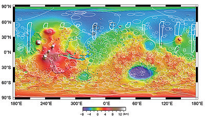