A Visit to Old Los
Angeles
7. New High Street; Justicia/Buena
Vista Street; Broadway (Part 1).
by
Brent C.
Dickerson
Copyright © Brent C. Dickerson
Index to Episodes (click here)
Circumspection.
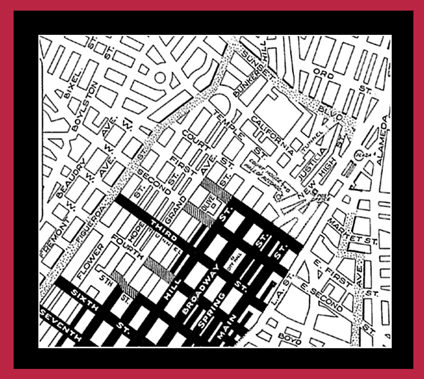
• Due to, first, a retention
of the very pleasant but haphazard original layout of the streets in the
area bounded by Main St. and Broadway, Temple St. and First St.; and,
secondly, the realignment and shuffling of some street names (as well as
the extinction of some streets) in this area in the late 1920s, it is not
easy for us to construe their arrangement in the period with which we are
concerned here, 1900-1920; even long-time Angelenos will be left blinking
when asked about "Jail St." or "Pound Cake Hill." We offer below a small
map of the area (the darkened areas represent streets which were in the
1920s considered prey to congestion, which Angelenos have been complaining
about in the downtown area since the 1890s) and a bird's-eye postcard of
the same area dating to approximately the mid-1930s. We show an extended
portion of downtown for the Reader's interest; the portion with which we
are concerned at present is near the middle of the map, about four-fifths
of the way towards the right. The Reader should bear in mind that this
area of Los Angeles, called overall "downtown" today, included as well
once upon a time a more suburban area on the "heights" of Los Angeles,
from Fort Hill just to the west of the old Plaza through Pound Cake Hill
(on which the County Courthouse was built), Bunker Hill, etc., the high
ground reaching diagonally from behind the Plaza to about Sixth and
Flower—thus such street names as "Hill" and "New High," and thus the
necessity for the funicular railways which will be mentioned subsequently.
Aside from the County Courthouse, the high ground tended to be an enclave
for "home life" (residences, schools, and the like), while the low ground
tended to be the governmental and business area.

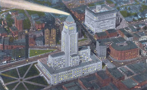
• In this early 1930s postcard view (and, broadly speaking, North is at the right, West at the top, etc.), the tall building at center is the new (and present) City Hall (if you happen to note "city hall" on the map above, don't be confused; the map is indicating old City Hall, on Broadway, which we shall be visiting soon), with Main Street on the near side of the building. Noting the green triangle just to the left of City Hall's tower in the picture: The street on its far side is New High Street, which we shall visit in a moment. On the triangle's left is Franklin Street, alias Jail Street. Formerly, on the near side of the triangle, the original alignment of old Spring Street would run parallel to New High Street, ending at Temple Street, which in this picture is the first street to the right of City Hall. On the same block as City Hall, between City Hall and Temple Street, is an old friend of ours, the International Savings and Exchange Bank Building, which we saw at the beginning of our walk down Spring Street; old Spring Street ran on the near side of this. Across Temple Street, the large brick building which you see near the right edge of the card is the Post Office, which we have also visited. Mr. Temple's old bank was in the blank space between City Hall and the Post Office. Finally, were this a present-day picture, the Hollywood/Santa Ana Freeway would be cutting through the upper right-hand corner of this view. But remove, now, the images in your mind of these newer buildings and the layout in this picture as we return to an earlier time . . .
A glance at New High Street.
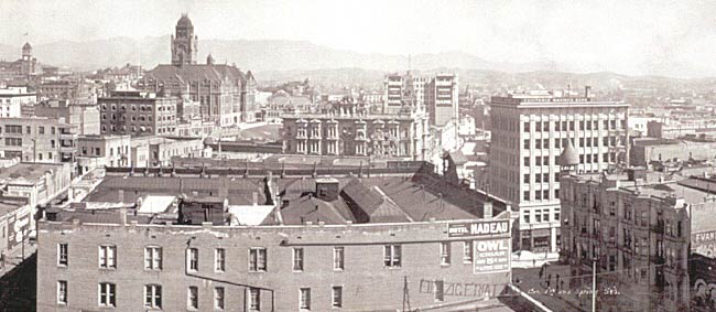
• New High Street was not sufficiently glamorous to engage the attention of postcard photographers on its own merits! We obtain some rare glimpses via enlargements of pieces of other postcard views and photographs. In this view, the County Courthouse on what's left of Pound Cake Hill dominates the center of the picture; the unseen street below the slope we see immediately to the right of the courthouse building would be New High Street, running parallel to the old "diagonal" block of Spring Street, which is the street seen stretching into the picture above the word "Nadeau" on the wall-sign in the foreground (we are looking down on the "alley side" of the Hotel Nadeau at Spring and First). At the left edge of the view, we see the tower of the High School, the previous incarnation of which was on the location of the Courthouse. Thus, the surroundings of New High Street!
• Returning to a standpoint at ground level two blocks north, at the junction of Temple, Main, and Spring, here is the building at the northwest corner of New High Street and Temple Street; that's the corner of the Post Office we see on the right.

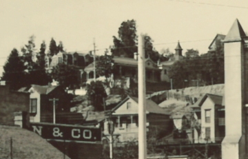
• If we were to turn right at that corner, and go north on New High Street, we would be in the precinct illustrated below, which is seen from the vantage point of the old Plaza. The "obelisk" we see on the right of this view is actually the south corner of the Plaza Church belltower. Nearest to us beyond the obelisk, the houses we see are on New High Street. The next parallel street farther is Buena Vista Street, once known as Justicia Street. Temple Street would be just beyond the farthest structure we see at upper left.
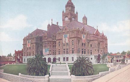
• We return to the corner of New High Street and Temple Street, and see the whole court house from that corner, with the small old Hall of Records immediately to its left. New High Street comes into the picture from the left; Temple Street peeks in at the view's lower right-hand corner. Note the size of the palm trees on either side of the steps up to the building.
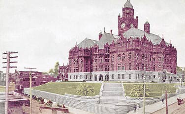
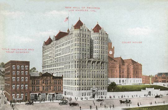
• The same view just a few years later: The part of New High Street fronting the County Court House and the new and gigantic Hall of Records (the latter being the only recognizable remaining building in our 1930s view above) which replaced the Jail, the perspective being from above the corner of New High St. and Temple St., looking southwest. One finds in trying to date postcards of the Court House that one of the best clues is the size of the two palm trees flanking the steps up. The County Court House was built on a rise known to the pioneers as Pound Cake Hill. From the top of the hill, in the mid-1800s, a look south was able to provide the viewer with the information that the horse-drawn stage from San Pedro was on its way via San Pedro Street, as the cloud of dust the stage rose far in the distance would be evident long long before the arrival of the coach.
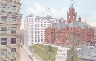
• Just then, as I was gazing abstractly at the Court House, I noticed young Frederick Johan strolling in one door. I leapt after him, and entered just in time to hear him asking a clerk if he could be let in to look up close at the mechanisms of the clock in the tower. The clerk looked at him over his glasses, adjusted his sleeve garters, put his pencil down, and pointed at the clock on the wall behind him. "That's the closest you'll come to any clock in this building, young man," he said, rather sternly, and with a sharp nod. I collared FJ and dragged him outside again. [Clock shown here, from the collection of Jim Robinson of Texas, is an actual clock from the old Court House; the name "Nordlinger" on its face refers to an old well-known jeweler's shop located back on Main St.]
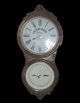
• The Court House was on the southwest corner of Temple and New High; in this much-enlarged excerpt from another postcard, we see—through the Court House's palm trees—the row of buildings on New High Street at the southeast corner, as well as (further into the picture) a tiny bit of the adjacent block of Spring Street around the latter's junction with Court Street and the quondam Market Street. This area is one of the historically-richest in downtown L.A.; the city's earlier court house was at this point of junction, its building reused from having originally been the city market.
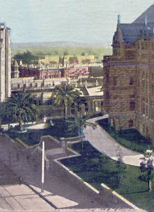
• We descend to ground level at Temple and New High, where it is easy to see the upward slope of Temple off to the right, while New High remains level towards the left. Note the small red brick building (the old Hall of Records) immediately to the left of the Court House.
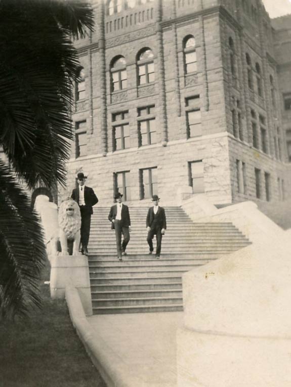
• Papa pointed out the piece of sculpture along the steps. "Ja, dere is alvays some lyin' at any court house. But I didn't tink dey would build a statue to it."
• We walk half a block south on New High Street, during which the small red brick building has been replaced by the new Hall of Records. This substantial building persisted long after all of its neighbors had been demolished, and was the last building in downtown Los Angeles to show the old alignment, being at an angle to all newer buildings. At left, we see west up Franklin Street to Broadway. At the far right is the County Jail building on Temple Street.
• A close-up of the Title Insurance & Trust Company Building, at the north-west corner of New High and Franklin streets. Again, we see west up Franklin to Broadway and across to the slope where the Court Flight funicular provides service from the heights of Bunker Hill's eastern extremity down to Broadway... as we shall see up close in our next episode.
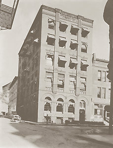
• In another stray, much-enlarged, and unsatisfyingly blurry snippet from another view, we see what is south across Franklin from the Title Insurance & Trust Building—the dark and unostentatious dead end of New High Street. No wonder the street did not attract postcard photographers!
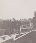
• We walk west on Temple towards Broadway. In the scene below, we see the north face of the Court House and the buildings across the street along Temple.
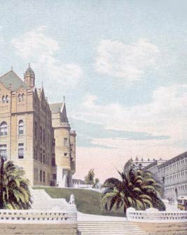
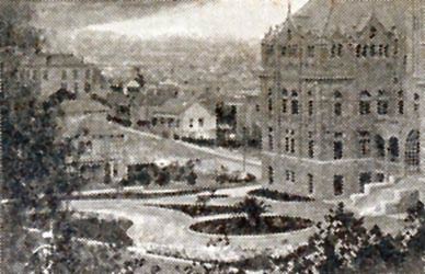
• In this older view, from a standpoint of the hill above Broadway and First, we look north past the Court House to the area around Justicia alias Buena Vista Street as it approaches its southern terminus at Temple Street. This modest residential neighborhood would soon be replaced by urban buildings. Also soon to be replaced would be the palm tree in front of the Court House entryway. The bronze statue of Angeleno lawyer and political figure Stephen M. White, which cost about $25,000, the amount being raised by public contribution rather than at civic expense, and which was unveiled December 11, 1908, would be sited there; the palm tree was moved, not cut down.
| • We look northwards at the west face of Justicia/Buena Vista Street just north of Temple. The suburban-looking residence in the foreground is at the northwest corner of Temple and Justicia, and is the longtime family home of the Bilderrain family, the L.A. presence of which was founded by Jose Ygnacio Bilderrain, who settled in L.A. probably between 1847 (when he got married in San Juan Capistrano) and 1850 or thereabouts (he appears in the 1850 L.A. census). His grandson of the same name was wounded in the strife which immediately preceded, and sparked, the Chinese Massacre of 1871. Some of the unfortunate Chinese were indeed lynched on the gatepost of the lumber-yard across Justicia from the Bilderrain home (the site is out of frame, to the right, and later hosted the Los Angeles County Jail). As late as 1928, Justicia Street was still a dirt road north of the part adjacent to the County Jail. | 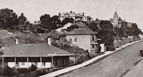
|
• Close by, the next street north, parallel to Temple Street, is California Street, the former Sand Street. The address of this fine boarding house is 498 California Street, and it had its moment of drama in 1902, as the Los Angeles Times of January 10, 1902, tells us: "An unknown enemy, whose motive is mysterious, made an almost successful attempt to poison the family of F.O. McKee of No. 498 California street Sunday by putting poison in the milk which had been left at the house by a dairyman. That the infant of Mr. and Mrs. McKee was not a victim is due only to the fact that the mother took a swallow of the poisoned milk before giving it to her babe, and was herself made violently ill. [...] Sunday afternoon the family was not at home, and about 2 o'clock neighbors saw the dairyman leave three bottles of milk on the front porch. Nothing was thought of this at the time, but someone noticed particularly that three bottles were left and later, while passing the place, saw that one was missing, although the family had not returned. Early Monday morning Mrs. McKee took some of the milk to prepare it for her baby. To see whether it was sweet, she drank a little from the bottle in which the dairyman had delivered it. She instantly detected a peculiar taste and a moment later felt a burning sensation in her mouth and throat. Soon afterward she became very ill, with all the symptoms of poisoning. [...] The milk had contained a caustic poison which severely burned her mouth, and even now she is unable to take solid foods. The poison could not have been in anything except the milk, for Mrs. McKee had taken nothing else. McKee immediately reported to the detectives. He says he received little satisfaction there, the officers not offering to investigate, or, if they intended to do so, giving him no intimation that such was their intention. He was told to consult the Milk Inspector. [...]" On hearing this story, Mother frowned. "I very much doubt," said she, "that the Milk Inspector has his finger on the pulse of the local baby poisoners!"
A Walk south down Broadway (part 1).
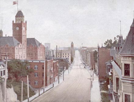
• Having walked the sloping block up Temple from New High Street to Broadway, our travelers begin their survey of Broadway looking south from atop the entrance to the Broadway tunnel penetrating Fort Hill. Behind is the intersection with California St.; half a block ahead is the intersection with Temple Street. Immediately to our left, we see how the approach to the tunnel has been carved into the hill. Ahead, we see coming up on our left the western face of the County Court House; mistily and vaguely in the distance behind the court house is the Union Trust Building on Spring; a few blocks ahead on Broadway is the tower of the old City Hall. Note the tower of the court house; we will be ascending it in a moment—at least, we men will be— the ladies refuse, absolutely refuse, to climb to the top of any more buildings with the children in hand!
| • A better—if fuzzier—look at the west side of this same stretch of Broadway north of Temple and just south of the tunnel. | 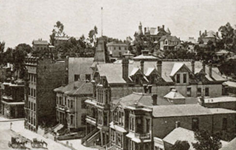
|
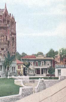 |
• We see a few buildings on the west side of Broadway just south of its corner with Temple. |
• We look at the court house
from the corner of Temple and Broadway, noting again the slope of Temple
to the left—which the ladies protest as the most tiresome blocklong
walk ever taken in the history of Man, nothing like it in
Nebraska—and we note how the new Hall of Records broods over and
enshadows the south wing of the court house. After all of the cement and
stonework of New High Street, Spring, and Main, the open expanse of grass
around the court house is refreshing and welcome.
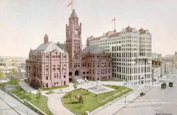
• Several of us ascend the court house tower. (I whispered to young Frederick Johan, "Please leave the clerks alone!" as we entered the building.) We look to the north. Prominent is the high school a few blocks away; we will visit it in just a few days. Nearer at hand is the Broadway tunnel which was our vantage-point a few minutes ago. We see that north, and west, is the residential district, on Los Angeles' higher ground. The high school, and the houses above the tunnel, are on Fort Hill, which we previously saw from another angle rising behind the old church at the Plaza. Formerly, Broadway was called "Fort Street"; old timers bitterly protested the name change as repudiating an important part of the city's heritage.

• Turning more towards the west, we see the high school presiding over more single family homes and some apartment houses. At mid-left, we get a glimpse of perhaps fifteen or twenty feet of Hill Street, the next parallel artery west of Broadway.
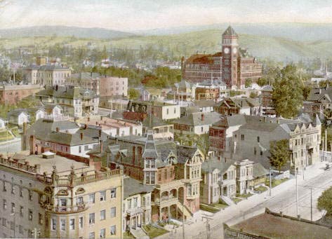
• Looking a bit more to the west, we see, at the left, more of the residential area atop Bunker Hill. This is an early view; the tower of the High School has not been roofed. Los Angeles' first High School can also be seen at mid-center, just to the right of the clump of trees; it was moved to that location from the site on which we take in the view, the top of Pound Cake Hill where the Court House was built. (It will help Modernity orient itself by knowing that the Hollywood Freeway passes from the lower right-hand corner of this view to a little below center at the left margin.)

• Now, to the southwest, the central latitude of the view showing the area in which Hill and Olive streets meet First St. The corner of Broadway and First is just out of view a little below left center.
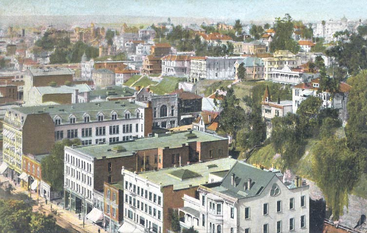
• Finally, we turn to the south, and see not only the length of Broadway, which we will travel down shortly, but also the broad flat expanse of the coastal plain. Yes, most certainly, the early citizens could have seen the dust of coaches coming towards Los Angeles from San Pedro to the south!—as well as the ocean itself, and Santa Catalina Island, on a clear day.

Return to Spring Street part two; or on to Broadway part two . . .