
Avery Sandborn – Mapping Prehistoric Landscapes in Kauai
Contents
[ hide ]
Mapping Prehistoric Landscapes in Kauai
Avery Sandborn University of Maryland-College ParkIntroduction
Researching past and present archaeological features and land cover can aid in studying the changes in Hawaiian landscapes. Data from remote sensing technologies and ground-truthing instruments can be merged with prehistoric maps and imagery to determine how archaeological and agricultural features have evolved since pre-European contact in Kauai. While in the field, color and infrared imagery from kites, blimps, and remote controlled planes, as well as coordinates from GPS technologies were obtained. Data analysis was completed by georeferencing and digitizing all relevant maps and imagery obtained from both the field and literature review. Ultimately, a time series of digital layers will aid in the restoration and preservation of native species and provide a historical context for archaeological research in Kauai.
Area of Interest
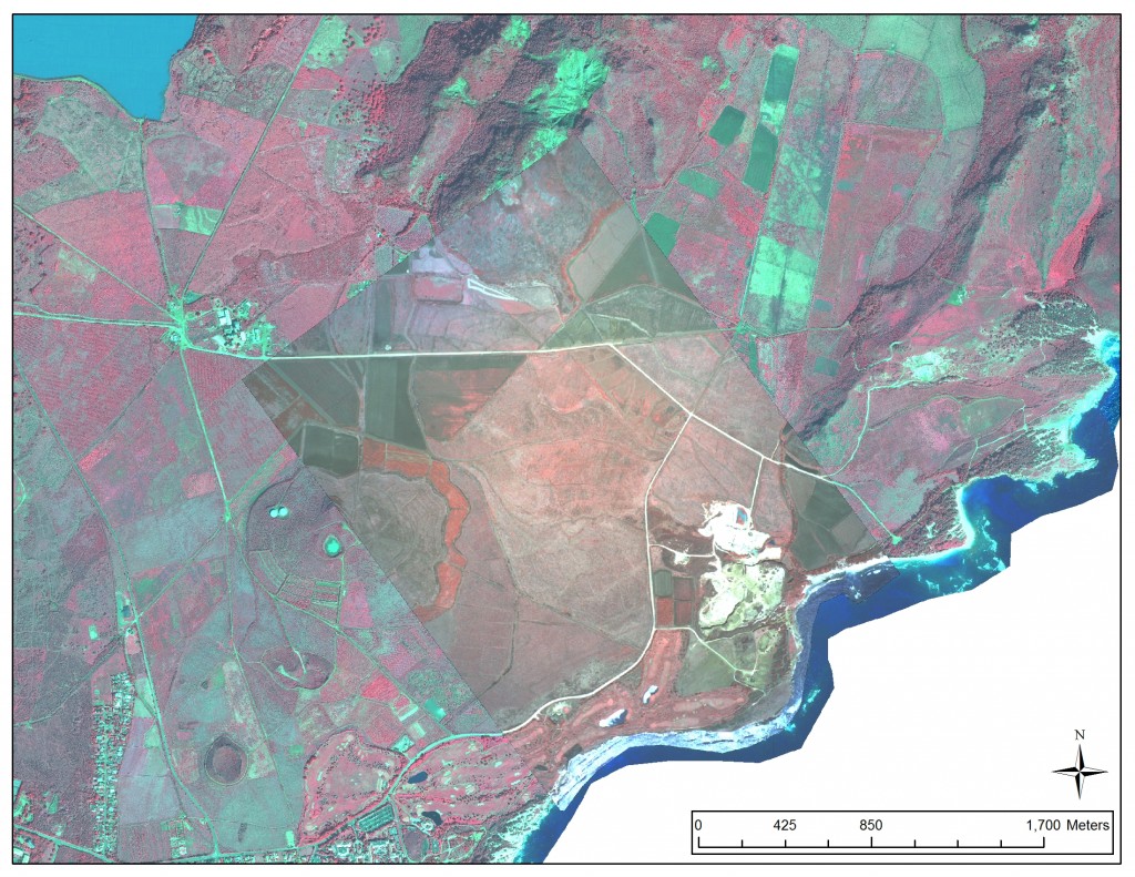
Figure 1: The study area is the southeastern fields of Kauai. The c. 1995 subset Pathfinder image overlays the World View 2 Imagery from c. 2006. Various geometric patterns can be seen on the agricultural fields in the subset image.
Data Acquisition
Cartographic and topographic data was obtained from the Grove Farm Sugar Plantation Museum. The maps and imagery were digitized and calibrated at a museum and were saved as a tiff file to be later georeferenced.
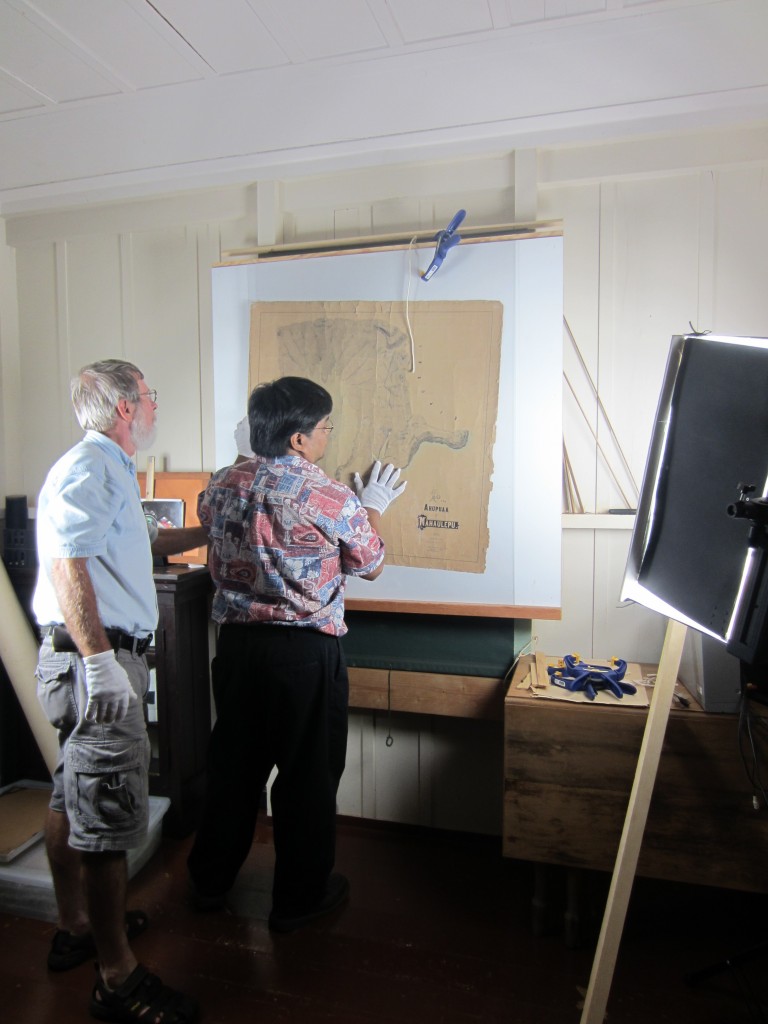
Figure 2: The maps were slid under a glass cover perpendicular to the floor, and clamped down.
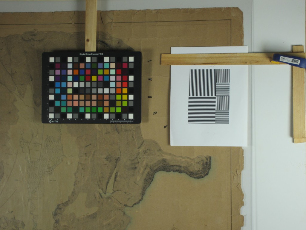
Figure 3: The maps were calibrated for color and focus before the scanning process began.
On-site remotely sensed information was collected from a variety of sources. The three main data collecting instruments were the Gatewing X100 Unmanned Aerial System, the Fixed-Wing Remote Controlled Aerial System, and the Kite Aerial Photography. Satellite data was obtained from NASA Pathfinder imagery (c. 1995) and WorldView 2 imagery (c. 2006).
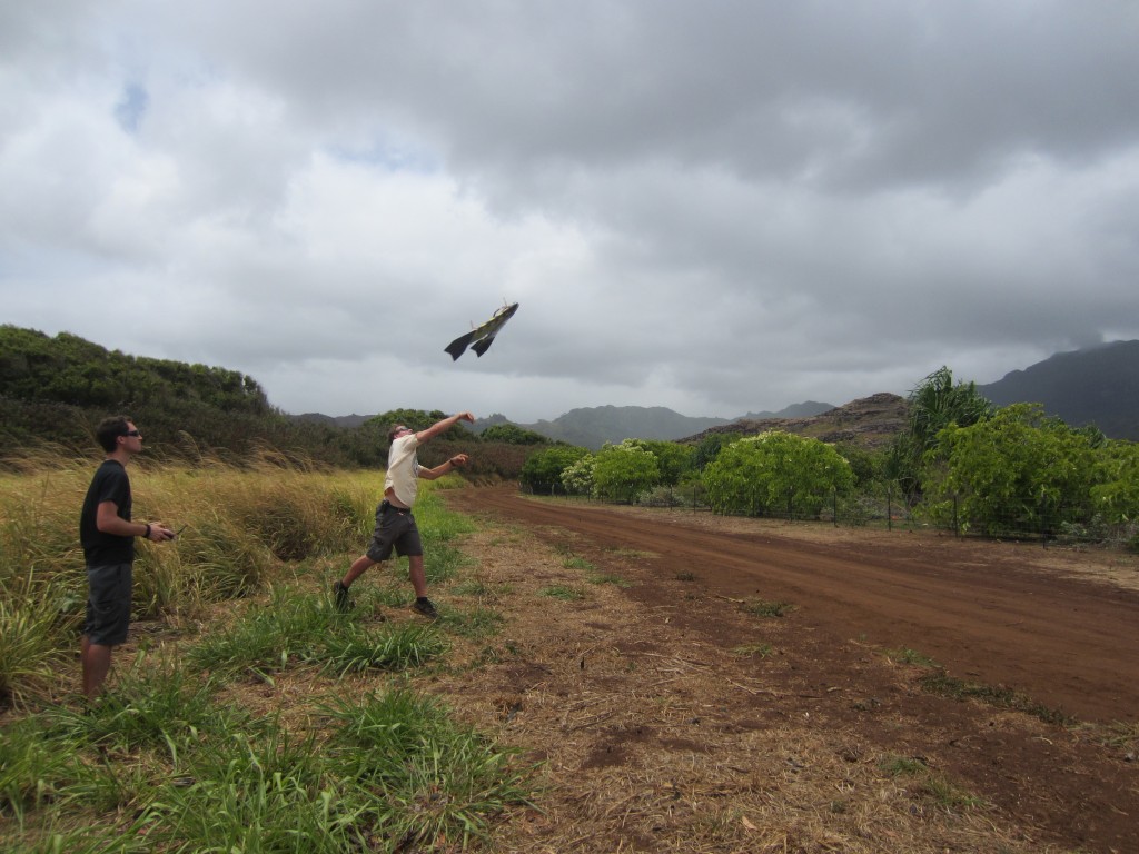
Figure 4: Launching the fixed-wing aircraft with a camera attached over the vegetation grid and agricultural fields.
Data Inventory
Data acquired was from a wide range of sources, had a wide range of dates, and was in various formats.
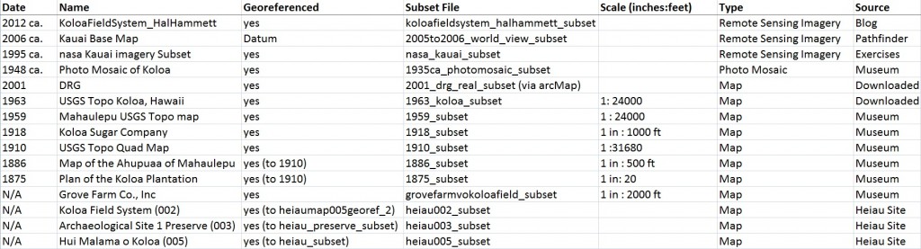
Figure 5: A list of maps and imagery used in this project.
Data Processing
Orthophotos (giant images of numerous images stitched together) were created using the PhotoScan software. The orthophotos can be used to create digital elevation models (DEMs) and can be georeferenced into the layered map.
Each map and image was georeferenced and clipped into a subset image in the Erdas and ArcGIS 10 software packages. Each file was georeferenced to the WorldView 2 image (with a few exceptions, see Figure 5). The aligned maps and imagery then allowed for easy comparison and manipulation in ArcGIS. Each georeferenced map was then clipped into a subset so that only the areas of interest were included.
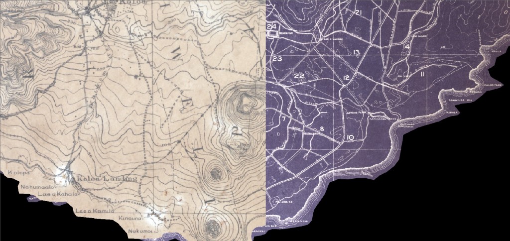
Figure 6: This figure shows two maps (left map from 1910, right map from 1918) georeferenced and clipped in Erdas, viewed using the swipe tool. The swipe tool allows the user to quickly maneuver the maps to view the same area on both maps.
Data Analysis
Once the maps and images were finished processing, analysis was able to be completed. In ArcMap, a layer of line features was created. The line features were traced over the Pathfinder imagery (c. 1995) and then overlaid onto other maps for comparison.
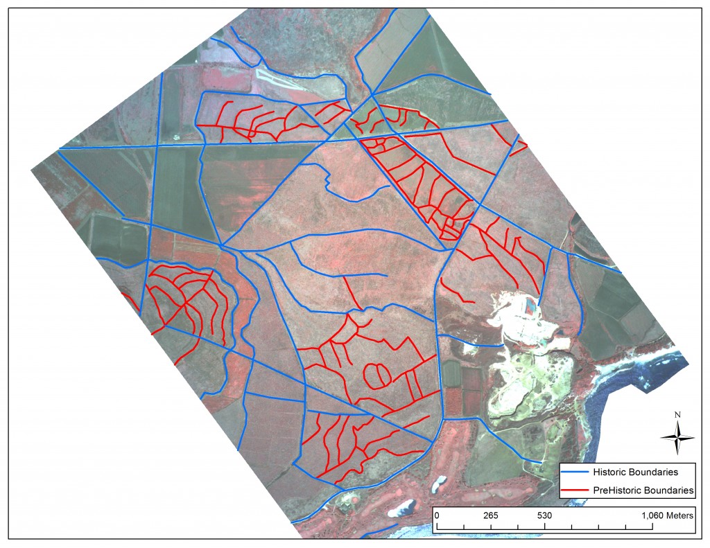
Figure 7: This figure shows digitized line features derived from the recent NASA Pathfinder imagery (c. 1995). An original line feature was created in ArcGIS 10 by tracing the roads, fences, and other boundaries on the datum image. The Grove Farm Quarry can be seen in the lower right of the image.
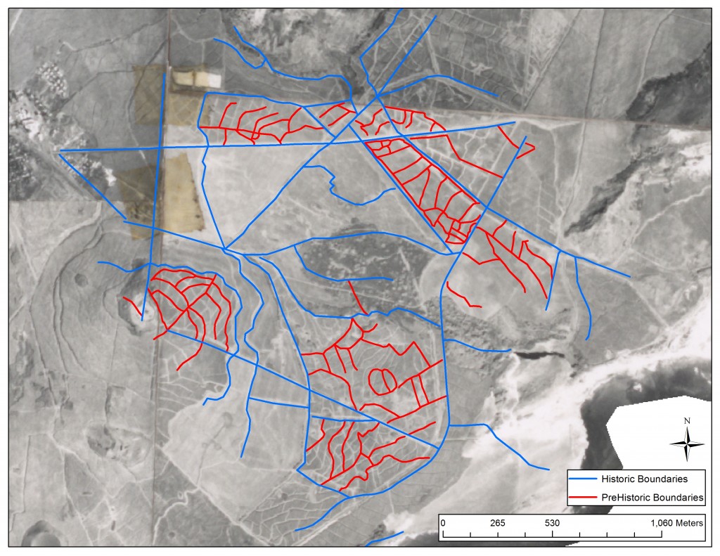
Figure 8: The same line features from Figure 7 were overlaid on an older photo mosaic (c. 1948). Older field boundaries can be seen on the image, as well as a dark region in the center of the image that do not appear in recent maps and imagery. Additionally, the quarry has not been built yet, and the Kaunakea Lake can be seen in it’s place.
Errors & Uncertainty
Although the Grove Farm Sugar Plantation Museum provided the project with numerous maps and imagery, a general lack of detailed historical data limits the project. This type of research would almost always benefit from having additional data. Also, some of the maps were missing dates and scales, and thus the time-series could be skewed if a map was viewed out of order. Additionally, the maps could contain producer error, evident from the fact that features on the map all have different shapes and sizes. User error could be produced from variability in georeferencing, as demonstrated by the calculated control point error in Erdas.
Conclusions & Future Work
An understanding of the cultural and physical landscape of Kauai rests in the context of its history, as represented through maps. This project represents the development of a baseline dataset that includes georeferenced historical maps and remotely sensed imagery. This representation allows for a detailed analysis through time on the landscapes, as portrayed through these maps, in order to better understand how the present landscape has been informed by the past.
This dataset reveals interesting correlations between the past and present archaeological features in Kauai. For example, geometric boundaries of agricultural fields, visible on remotely sensed imagery, reveals a potential correlation between the modern appearance of an agricultural field and the topography recorded on prehistoric maps. Further fieldwork could determine a significant relationship. Through the time-series of maps, one can discover when certain archaeological features began to appear or disappear. This research is presently being used to assist in the Grove Farm Quarry restoration and preservation efforts. Additional maps and imagery can be georeferenced for a more thorough repository.
Acknowledgements
I would like to thank the following people and organizations for their dedicated support and insight:
Dr. Carl Lipo, Dr. Suzanne Wechsler, Dr. Christopher Lee, Dr. Matt Becker, California State University Long Beach, Dr. David Burney, National Tropical Botanical Garden, Grove Farm Sugar Plantation Museum, National Science Foundation, Paul Nesbit, Mike Ferris, Briton Voorhees, Jake Kovalchik, Wes Ellis, Ted Ralston, Hal Hammett, Lida Pigott Burney, Matthew Lucas, Teddy Blake, Chuck Blay, Terry Hunt, Chuck Devaney, Dave Hummer, University of Hawaii, Mary Werthwine, Samantha Hauser, John O’Connor, and Lawrence Fujiwara
The research was made possible by the National Science Foundation, Research Experiences for Undergraduates Program, NSF Award No.1005258, Geospatial Research and Mapping (GRAM)