
The Effects of Coastal Geology on Submarine Groundwater Discharge in Southeast Kauai
Abstract
Abstract text goes here…
Introduction
Submarine groundwater discharge (SGD) refers to the movement of the fresh water from the bedrock into the ocean.
Understanding the dynamics of SGD on the island of Kauai requires an understanding of the island’s geology and rock structure. The southeast coast of Kauai is made up of a variety of rock types including: dark weathered limestone, iron oxide limestone, white limestone, and volcanic basalt.
Rock samples were analyzed using GPS and spectrometer readings. The GPS locations of the specific rock types were used to classify rock type in two different satellite images (Worldview-2 and Advanced Land Imager) using ERDAS Imagine.
Methods
To investigate how the coastal geology affects the submarine ground water discharge:
Rock samples were taken from eleven different sites along the Māhā’ulepu and Pā’ā coastlines.
A spectrometer was used to read the reflections of each rock, providing unique spectral signatures for each rock.
ArcGIS
GPS locations of the rock samples were identified on Worldview-2 imagery of Kauai, as well as Chuck Blay’s map (Figure 1), which illustrates the relative age of bedrock along the Southeast coast.
ERDAS Imagine
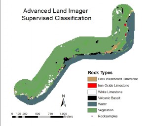
Two Supervised Classifications on Advanced Land Imager (Figure 2) and Worldview-2 (Figure 3) were used to identify rock locations on the imagery.
Data
The Advanced Land Imager (ALI) has 3 mid-IR bands that are useful for identifying rocks and minerals. Unfortunately, the pan sharpened image was still too coarse at 10 meter pixels. The precise location of each rock type could not be represented at this scale; The supervised classification of ALI had the wrong type of rocks showing up in the wrong areas and was unable to classify the rocks based on the classifications provided from the field ground truth.
The supervised classification of the pan sharpened Worldview-2 image, though a higher spatial resolution, came out a lot more accurate but still was not exact. This imagery does on have any mid-IR bands, but this image turned out better when looking at the resolution.
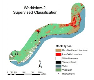
The Rock Type table (Table 1) provides a comparison between the rock types identified through fied ground truth and the co-located rock types resulting from the supervised classification. The ALI image has a 72% similarity with the ground truth data whereas the Worldview-2 has a 91% similarity.
| Samples | Rock Type | Supervised Classification | |
| Advanced Land Imager (ALI) | Worldview2 | ||
| 1 | Dark Weathered Limestone | Basalt | Dark Weathered |
| 2 | Iron Oxide Limestone | Iron Oxide | Iron Oxide |
| 3 | Iron Oxide Limestone | Iron Oxide | Iron Oxide |
| 4 | Dark Weathered Limestone | Dark Weathered | Dark Weathered |
| 5 | Dark Weathered Limestone | Dark Weathered | Dark Weathered |
| 6 | Volcanic Basalt | Basalt | Basalt |
| 7 | Dark Weathered Limestone | Dark Weathered | Dark Weathered |
| 8 | White Limestone | Vegetation | White |
| 9 | Volcanic Basalt | Vegetation | Basalt |
| 10 | White Limestone | White | Dark Weathered |
| 11 | White Limestone | White | White |
The spectral readings of the rock types (Figure 4) shows the unique spectral signatures of the different rock types. This graph helped me decide which spectral signatures correspond to which rock types.
Conclusions
The higher spatial resolution of the Worldview-2 imagery provides a better visual representation of the classification results. However, with future research a mid-IR band, in ALI could provide a more accurate classification of rocks and minerals.
The rock types identified through the field data collection were easily identifiable on Chuck Blay’s map of the Māhā’ulepu and Pā’ā coastlines. However, his map omitted volcanic basalt.
We cannot currently identify whether the carbonate and basaltic rocks have any effects on the submarine groundwater discharge.
Acknowledgements
Thanks to the California State University Long Beach, the National Tropical Botanical Garden, Dr. David Burney, Dr. Lida Burney, Dr. Matt Becker, Dr. Christopher Lee, Dr. Suzanne Wechsler, Dr. Carl Lipo, Ted Ralston, Wes Ellis, Mike Ferris, Jake Kovalchik, Paul Nesbit, Briton Voorhees, Kelly Acridge, Courtney Fiamengo, and Alessandra Pistoia
This Research was made possible by the National Science Foundation Research Experiences for Undergraduates Program
NSF Award # 1005258 Geospatial Research and Mapping (GRAM).