
PAP at Hoouluia
June 21, 2012Aloha,
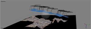
Today, our archaeological team recorded images for Hoouluia heiau at Mahaulepu using a pole-aerial-photographic (PAP) approach. A GoPro HERO2 camera was affixed to the top of a large carbon fiber pole approximately fifteen feet in height. The camera was positioned facing perpendicular to the ground and photos were recorded at ten second intervals. Photos were taken along transects for the makai (towards the sea) half of the structure. The goal of this exercise was to generate data for the creation of orthophoto and digital elevation model (DEM) imaging for the archaeological structure using basic equipment. Almost four hundred photos were captured. Three hundred sixty-eight of these photographs were imported into Agisoft Photoscan, and an orthophoto was created for the recorded portion of the heiau (see below).
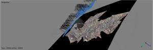
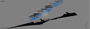
I was disappointed with the results of this approach. These images are not accurate representations of Hoouluia. The isolated spatial range of this specific PAP acquired imagery and the appearance of the basalt used for heiau construction did not overlap well in the Photoscan software. I will not be continuing PAP on this archaeological structure. Instead, I will begin processing data obtained from a kite-aerial-photography (KAP) platform and the other airborne remote sensing units. These latter approaches will hopefully contribute to more accurate imaging from which pointcloud data can be extracted for DEM analysis.
– John Thornton O’Connor