
Map making and academic poster construction
July 6, 2012Aloha kakou,
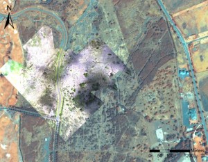
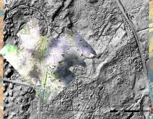
This morning was spent preparing maps for my research presentation tomorrow morning. My academic poster is titled Remote Sensing and Ancient Polynesian Landscapes. Last month, I set out to determine what remote sensing platforms and methods are most effective for the identification of archaeological features. I determined that LIDAR-derived imagery was the best approach for recognizing Hawaiian archaeological structures at the regional scale. Certain features that have been obscured over time, such as habitation platforms and agricultural field boundaries, become visible through manipulation of LIDAR digital elevation models. Orthophotos created from lower altitude suborbital photography can complement satellite and LIDAR imagery for high resolution analysis of basalt aggregates. I included various maps to illustrate how different imagery can serve to depict various features (see below).
The GRAM program comes to an end tomorrow. We will be presenting our research around 10:00am at the CSULB campus. Poster information will be posted for each research project, and academic posters will be uploaded to the NSF-REU site following completion of the program.
– John Thornton O’Connor