
Getting my blimp-flying license
June 15, 2012This day proved to be much more hands-on than the others, all of our activities included learning how to work a clutch piece of technology or a neat gadget. We rotated through three stations; first we learned to function both Garmin and Trimble GPS systems, the latter of which was essentially a small (but heavy) computer in your hands that allowed for on-ground digitizing, followed by an introduction to spectroscopy and the use of a spectrometer which we will use on Kauai to look at the vegetation and compare the results of that to the near-infrared aerial images we will be taking. We finished up the rotations by learning to use an XRF (X-Ray Fluorescence) hand-held device to shoot x-rays at soil samples and look at the elemental composition which we will use to analyze prehistoric soils to identify past agricultural practices. This is a really neat gadget that can be used for identifying forgeries in paintings and other objects by comparing things like paint, ceramic or glass composition. See image below.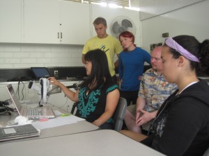
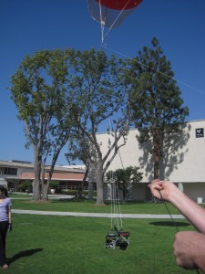
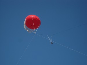
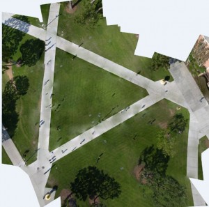
In the afternoon we used a blimp to take aerial images (NIR and 3-band) of a quad on campus. It ended up being much more stressful than I expected, but every time the $20,000 camera plummeted towards the concrete when the blimp took a dive in the wind I think I lost five years off of my life expectancy. In the evening I created an orthophoto of the images taken on the blimp, which ended up looking pretty neat particularly when there was one person who showed up numerous times in the picture or when there were shadows without a source or people without shadows.
I ended my night by trying to convert the point cloud I created of the trash can yesterday into a DEM following directions found on a blog, but I had to stop partway through because the only program available to do part of the conversion was completely in German. I also got to experience an In and Out, which was not very tasty.
Go beach!